- Susitna River
Infobox_River
river_name =Susitna River
image_size =
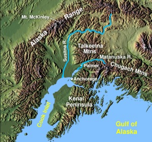
caption = Susitna River inSouthcentral Alaska
origin = coord|63|26|10|N|147|11|55|W|region:US-AK_type:river_source:GNISGnis|1416406|Susitna River]Susitna Glacier onMount Hayes
mouth = coord|61|16|14|N|150|34|33|W|region:US-AK_type:river_source:GNIS|display=inline,titleCook Inlet ofPacific Ocean
basin_countries =United States of America
length = convert|313|mi|km
elevation = Unit ft|2500|0
mouth_elevation = Unit ft|0|0
discharge = convert|51000|cuft|m3 per second at mouthcite web
title = Largest Rivers in the United States
publisher =United States Geological Survey
url = http://pubs.usgs.gov/of/1987/ofr87-242/pdf/ofr87242.pdf
format =PDF
cite web
title = Largest Rivers in the United States
publisher =United States Geological Survey
url = http://pubs.usgs.gov/of/1987/ofr87-242/
format =HTML ]
watershed = convert|20000|sqmi|km2The Susitna River (pronEng|suːˈsɪtnə) is a convert|313|mi|km long
river in the southcentral region of theU.S. state ofAlaska . It is the 15th largest river in the United States of America, ranked by average discharge volume at its mouth. The river stretches from theSusitna Glacier toCook Inlet .History
Tanaina Indian name meaning "sandy river" published by theRussia n Hydrog. Dept. as "R(eka) Sushitna," meaning "Sushitna River", on Chart 1378 dated 1847. The Susitna River appears to have been first explored in 1834, by a "Creole namedMalakov ", and the name may have been obtained by the Russians at that time (Dall, 1870, p.12,273). The present spelling of the name has evolved due toeuphemistic reasons.Description
The Susitna River heads at
Susitna Glacier , inAlaska Range , flows southwest toCook Inlet , convert|24|mi|km west ofAnchorage, Alaska Cook Inlet Low.There are several rivers flowing into the Susitna River including East Fork "Susitna River" and West Fork "Susitna River". The
Little Susitna River is a separate river system which flows into theCook Inlet on the other side ofSusitna Flats .The Susitna along with the
Matanuska River , drains the broadMatanuska-Susitna Valley south of theAlaska Range . cite web
title = 15292000 Susitna River atGold Creek
publisher =United States Geological Survey
url = http://ak.water.usgs.gov/Publications/water-data/WY96/15292000.htm]It rises in the
Susitna Glacier onMount Hayes in theAlaska Range near coord|63|30|N|147|15|W|region:US-AK_type:river_source:GNIS. It flows in winding course generally southwest to Curry, then south, along the west side of theTalkeetna Mountains , past Talkeetna,Chulitna River , and Susitna, and drains intoCook Inlet approximately 25 mi (40 km) west of Anchorage.It receives the
Yentna River from the northwest approximately 5 mi (8 km) north of Susitna. It is navigable to 85 mi (137 km) upstream from its mouth to Talkeetna.The Susitna River is one of
Southcentral Alaska 's premier sportfishing streams, with significant runs of Chinook andCoho salmon , along with residentgrayling ,burbot , andrainbow trout . Located within a roadless area, access to the river is difficult and is made usually by power boat or by floatplane.Matanuska-Susitna Borough owns much of the land along the Susitna andDeshka River s. The impacts of summer recreational use and tourists have caused loss ofriparian vegetation and bankerosion along theDeshka River 's lower reaches, which has been partially remedied through a restoration project in the summer of 2002. However, theborough currently lacks either regulations to prevent further damage or the means to enforce such regulations.Etymology
Susitna River was named by the
Dena’ina Alaska Native people meaning "sandy river". The Susitna appears to have been first explored in 1834 by a Creole Indian namedMalakor . The 1890census reported that Susitna Village on the east bank of the river had 146Kenai Natives and 27 houses.Location
(1329) Susitna River is on the North side of
Cook Inlet convert|22|mi|km North-East ofNorth Foreland .Mount Susitna ,a prominent landmark along the upper part of the inlet,is about convert|6|mi|km West of the Susitna River at a point convert|13|mi|km above the mouth. cite web
title = Coast Pilot (R) Volume 9, Chapter 4, Pages: 124,224 - Susitna River nautical chart narrative
publisher =National Oceanic and Atmospheric Administration
url = http://www.nauticalcharts.noaa.gov/nsd/Cp9/CP9-25ed-Ch04_9.pdf
format =PDF ](1330) The channels across the flats at the mouth of Susitna River have depths of Unit ft|2|1 or less at low water and change during the winter and spring because of ice and
freshet action.The channels above the mouth are said to change frequently in the spring and early summer.(1331) Launches navigate Susitna River to
Yentna River ,about convert|20|mi|km aboveCook Inlet ,thence run occasionally up theYentna River to the forks about convert|65|mi|km from the Susitna River.The tides are not felt more than convert|7|mi|km from the inlet,and above this the current is swift.Overhead power cables with a least clearance of Unit ft|37|0 cross the Susitna River about convert|5|mi|km above its mouth.(1332)
Alexander, Alaska is a small settlement on the west side of Susitna River convert|10|mi|km above the mouth.Susitna, Alaska is on the East side convert|18|mi|km above the mouth and just below the mouth of theYentna River ;
launches run to and fromAnchorage, Alaska .Mail is delivered to both settlements twice monthly by airplane fromAnchorage, Alaska .(1333)
Susitna Flats lies between big Susitna River andLittle Susitna River and to the East of the latter.Susitna Flats Light coord|61|15|10|N|150|29|17|W|region:US-AK_type:landmark_source:GNIS,Unit ft|19|1 above the water,is shown from askeleton tower and is equipped with aracon .(1334)
Little Susitna River , convert|9|mi|km West ofPoint MacKenzie ,is said to be navigable forlanding craft andskiff s athigh water for about convert|8|mi|km.(1335) Caution:the depths offshore and in the approach to
Little Susitna River are subject to drastic and continual change.Ice
Between approximately October 19th and November 14th the Susitna River ices or freezes over for the winter. cite web
title = Technical Report on Cook Inlet Marine Ice - including the big Susitna River]
publisher =U.S. Army Corps of Engineers
url = http://www.crrel.usace.army.mil/techpub/CRREL_Reports/reports/TR-01-10/text.pdf
format =PDF ] Between April 12th. and May 10th the ice breaks-up for the summer.Tributaries
*East Fork Susitna River
*West Fork Susitna River
*Yentna River
*Deshka River
*Talkeetna River
*Chulitna River
*Oshetna River
*Tyone River
*Maclaren RiverReferences
ee also
*
List of Alaska rivers External links
*
National Oceanic and Atmospheric Administration :*cite web
title = Cook Inlet - Northern part 1:194,154 nautical chart 16660
publisher =National Oceanic and Atmospheric Administration
url = http://www.charts.noaa.gov/OnLineViewer/16660.shtml:*cite web
title = Cook Inlet-Approaches to Anchorage, Alaska; 1:50,000 nautical chart 16665
publisher =National Oceanic and Atmospheric Administration
url = http://www.charts.noaa.gov/OnLineViewer/16665.shtml:*cite web
title = Cook Inlet-East Foreland to Anchorage, Alaska; North Foreland 1:100,000 nautical chart 16663
publisher =National Oceanic and Atmospheric Administration
url = http://www.charts.noaa.gov/OnLineViewer/16663.shtml*cite web
title = Matanuska-Susitna, Wasilla & Palmer Area History
publisher = Agate Inn
url = http://www.agateinn.com/area.htm
Wikimedia Foundation. 2010.