- Little Susitna River
Infobox_River
river_name = Little Susitna River
image_size =
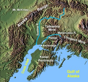
caption = (big &) Little Susitna River inSouthcentral Alaska
origin = coord|61|51|31|N|149|03|48|W|region:US-AK_type:river_source:GNISMint Glacier onMontana Peak inTalkeetna Mountains
mouth = coord|61|15|03|N|150|17|17|W|region:US-AK_type:river_source:GNIS|display=inline,titleCook Inlet ofPacific Ocean
basin_countries =United States of America
length = convert|110|mi|km
elevation = Unit ft|1700|0
mouth_elevation = Unit ft|0|0
discharge = convert|206|cuft|m3 per second at mouth
watershed = convert|61.9|sqmi|km2History
Local name published in 1898 by USC&GS.
Description
Little Susitna River heads at
Mint Glacier onMontana Peak , inTalkeetna Mountains at coord|61|51|30|N|149|03|30|W|region:US-AK_type:river_source:GNIS, flows SW toCook Inlet , convert|13|mi|km W ofAnchorage, Alaska Cook Inlet Low. cite web
title =15290000 LITTLE SUSITNA RIVER NEAR PALMER
publisher =USGS
url = http://ak.water.usgs.gov/Publications/water-data/WY96/15290000.htm]Location
(1334)
Little Susitna River , convert|9|mi|km West ofPoint MacKenzie ,is said to be navigable forlanding craft andskiff s athigh water for about convert|8|mi|km. cite web
title = Coast Pilot (R) Volume 9, Chapter 4, Pages: 124,224 - Susitna River nautical chart narrative
publisher =NOAA
url = http://www.nauticalcharts.noaa.gov/nsd/Cp9/CP9-25ed-Ch04_9.pdf
format =PDF ](1335) Caution:the depths offshore and in the approach to
Little Susitna River are subject to drastic and continual change.The Little Susitna River is a
river inAlaska . It originates inHatcher Pass , at Unit ft|1700|0, in theTalkeetna Mountains which form the northern boundary of theMatanuska-Susitna Valley . It flows a few dozen miles to theCook Inlet . It contains a variety of hydrology ranging from flat water near the inlet to class 5 water inHatcher Pass . It is bridged byFishook Road inHatcher Pass ,Edgerton Parks Road ,Welch Road ,George Parks Highway , andSchrock Road . It flooded in 1972 and again in August 2006, causing minor damage to homes and infrastructure. Popular activities along the river include camping, fishing, wildlife viewing and photography, and hunting.Access
The river begins in
Hatcher Pass , a state recreation area that was origonaly opened by hard rock mining. This area still has active gold mines and is also open for recreational mining. Much of the land betweenHatcher Pass and theGeorge Parks Highway bridge is privately owned, while most of the land below theGeorge Parks Highway Bridge is owned by the state. TheGeorge Parks Highway crosses the river at RM 69.5 and parallels the river for about a mile. 42 river miles down stream there is the Little Susitna Public Use Facility, which offers camping and boating access approximately convert|26|mi|km south ofWasilla . This campground/boat launch lies within theSusitna Flats State Game Refuge on the pristine Little Susitna River.Fishing
The
Alaska Department of Fish and Game operates aweir to countCoho salmon andSilver salmon in river. The Little Susitna River weir is located about one-half mile upstream of theGeorge Parks Highway bridge. Salmon fishing is closed upstream of theGeorge Parks Highway , so the weir counts indicate the number of fish getting past the sport fishery. The Little Susitna River provides a multitude of sport angling opportunities.King salmon ,Silver salmon ,Chum salmon ,Red salmon , andPink salmon are available, as well as someDolly Varden andRainbow trout . Several other less targeted species such asArctic grayling ,burbot , roundwhitefish andnorthern pike also call the Little Susitna River home.References
External links
*cite web
title = Sport Fishing
publisher = State of AlaskaDepartment of Fish and Game
url = http://www.sf.adfg.state.ak.us/statewide/accessprogram/Programpage.cfm?type=1®ion=2&projectid=3
*cite web
title = State of Alaska Department of Fish and Game
url = http://www.adfg.state.ak.us/
*cite web
title = 2007 Regulations
publisher = State of AlaskaDepartment of Fish and Game , Sport Fisheries
url = http://www.sf.adfg.state.ak.us/statewide/regulations/2007/southcentral/07SCknikarm.pdf
format =PDF
*cite web
title = GNIS Geographic Names Information System Query
publisher =USGS
url = http://geonames.usgs.gov/pls/gnispublic/f?p=gnispq*
List of Alaska rivers
Wikimedia Foundation. 2010.