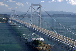
- Ōnaruto Bridge
-
Ōnaruto Bridge
(大鳴門橋 Ōnaruto-kyō)
from Mt. NarutoCarries 4 lanes of roadway Crosses Naruto Strait Locale Naruto, Tokushima and Awaji Island Maintained by Honshū-Shikoku Bridge Authority Design Suspension bridge Longest span 876 metres (2,874 ft) Clearance below 41 metres (135 ft) Opened 1985 Daily traffic 18,600 Coordinates 34°14′19″N 134°39′05″E / 34.23861°N 134.65139°ECoordinates: 34°14′19″N 134°39′05″E / 34.23861°N 134.65139°E The Ōnaruto Bridge (大鳴門橋 Ōnaruto-kyō) is a suspension bridge on the route connecting Kobe with Naruto, Tokushima, Japan. Completed in 1985, it has a main span of 876 metres (2,874 ft). Although it is one of the largest bridges in the world, it is dwarfed by the Akashi-Kaikyo Bridge, which is on the same route. In 2004, 6.8 million cars and trucks crossed this bridge, translating into a daily average of about 18,600.
Naruto Whirlpools
Recurring whirlpools known as the Naruto whirlpools are located below the bridge, caused by tidal currents between the Seto Inland Sea and the Pacific Ocean passing over undersea ridges under the Span, causing very strong eddy currents, some of which make large, deep whirlpools.
The bridge has a tourist attraction built into the south side anchor—the Uzunomichi Walkway[1]—an enclosed walkway out to the south tower to allow visitors to view the swirls through side and floor windows, best seen during low tide. Tourist boats and other vessels circle the towers, allowing visitors to actually see the depth of the whirlpools up close, while the view from the bridge observatory lets visitors see the pattern created by the eddy currents extending out for quite a distance.
References
External links
 Media related to Ōnaruto Bridge at Wikimedia Commons
- Ōnaruto Bridge at Structurae
- Honshu Shikoku Bridge Expressway Company
- Welcome! Shikoku — Naruto Whirlpools English Page
Crossings of the Kobe-Awaji-Naruto Expressway North
Akashi-Kaikyo BridgeŌnaruto Bridge South
ShikokuCategories:- Suspension bridges in Japan
- Bridges completed in 1985
- Japanese building and structure stubs
- Asian bridge (structure) stubs
Wikimedia Foundation. 2010.
