- Maliku Atoll
-
Minicoy
Atoll Summary Administrative name Minicoy Atoll name Maliku Atoll Location Population 9495 No. of Islands 2 Inhabited Islands 1 Inhabited Islands Maliku Uninhabited Islands
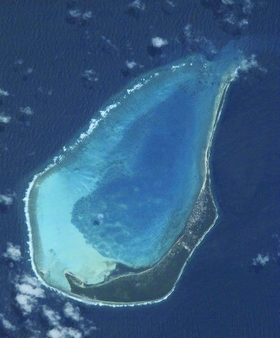
Resort islands, Airports and Industrial islands are also considered uninhabitedMaliku Atoll or Minicoy Atoll is the southernmost atoll of the Union Territory of Lakshadweep, India. It is located 201 km to the SSW of Kalpeni, at the southern end of the Nine Degree Channel and 125 km to the north of Thuraakunu, Maldives, at the northern end of the Eight Degree Channel. The atoll is 10 km in length, having a maximum breadth of about 6 km. The closest geographic feature is the Investigator Bank, a submerged shoal located 31 km to the northeast of this atoll at 8˚32'N, 73˚17'E.[1]
Contents
Islands
There are only two islands in this atoll:
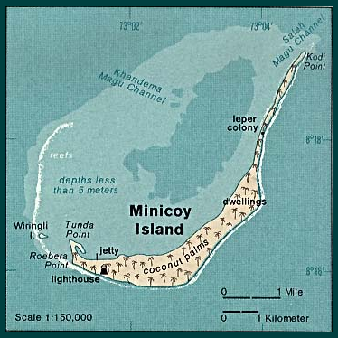
- Minicoy, a large inhabited island located on the eastern and southeastern side of the lagoon, along the reef fringe. It measures about 10 km from its northern end to its southernmost point and it is about 1 km wide in its southern half, while the northern half is a narrow sandspit, often less than 100 m wide. Minicoy is almost completely covered with coconut trees. One of the few landmarks of the island is a tall lighthouse. Unlike the other islands of the U.T. Lakshadweep, the language spoken in Minicoy is Dhivehi, known locally as Mahl. The island has many cultural affinities with the Maldives.
- Viringili, a small islet located on the southwestern reef edge. It is barely 200 m in length. Formerly the lepers of Minicoy were banished to this island where they lived in abject conditions.
 Map of Minicoy Atoll (Maliku)
Maliku Atoll has a lagoon with two entrances in its northern side, Saalu Magu on the northeast and Kandimma Magu on the northwest. Its western side is fringed by a narrow reef and coral rocks awash. The interior of the lagoon is sandy and of moderate depth, rarely reaching 4m. It has some coral patches.
Maliku Kandu
Maliku Kandu is the traditional name of the broad channel between Minicoy (Maliku) and Ihavandippulhu (Haa Alif Atoll) in the Maldives. In the Admiralty Charts it is called Eight Degree Channel. Other names for this channel are Addigiri Kandu and Māmalē Kandu. It appeared in old French maps with the name Courant de Malicut.
History
Maliku Atoll has been under Indian administrations since mid 16th century. It was the northernmost atoll of historical Maldives before mid 16th century. In December 1976, India and the Maldives signed a maritime boundary treaty whereby Maliku was placed on the Indian side of the boundary.[2]
However, on 26 July 1982, Abdulla Hameed, the half-brother of Maldivian president Maumoon Abdul Gayoom and the Minister of Atolls for the Maldivian government, gave a speech in which he declared that Minicoy Island was part of the Maldives.[3] The speech caused a minor diplomatic crisis between India and the Maldives, and Gayoom clarified that the speech was intended to highlight the linguistic, cultural, and religious ties between the Maldives and Minicoy and that the Maldives was not intending to make a political claim over the atoll.[3]
References
- ^ Hydrographic Description (Indian Ocean Pilot)
- ^ "India–Maldives: Agreement between India and the Maldives on Maritime Boundary in the Arabian Sea and Related Matters", in Jonathan I. Charney and Lewis M. Alexander (eds., 1998). International Maritime Boundaries (Leiden: Martinus Nijhoff Publishers, ISBN 978-9041103451) pp. 1389–1399.
- ^ a b Ramesh Trivedi (2007). India's Relations with her Neighbours (Isha Books, ISBN 978-8182054387) p. 177.
- Divehi Tārīkhah Au Alikameh. Divehi Bahāi Tārikhah Khidmaiykurā Qaumī Markazu. Reprint 1958 edn. Male’ 1990.
- Divehiraajjege Jōgrafīge Vanavaru. Muhammadu Ibrahim Lutfee. G.Sōsanī.
- Xavier Romero-Frias, The Maldive Islanders, A Study of the Popular Culture of an Ancient Ocean Kingdom. Barcelona 1999, ISBN 84 7254 801 5
- "The Encyclopaedia of Islam", new edition, Index Volume, Fascicule 2, Glossary and Index of Terms, Bill, 2006, LARGE book-size paperback, 592 pages, ISBN 978-90-04-15610-4.
Categories:- Atolls of the Indian Ocean
- Islands of Lakshadweep
- India–Maldives border
- Territorial disputes of India
- Territorial disputes of the Maldives

Wikimedia Foundation. 2010.