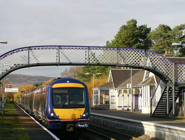
Carrbridge railway station
- Carrbridge railway station
Infobox UK station
name = Carrbridge
other_name= Drochaid Chàrr
code = CAG

caption =
manager = First ScotRail
locale = Carrbridge
borough = Highland
latitude = 57.280
longitude = -3.828
platforms = 2
lowusage0203 = 1,531
lowusage0405 = 1,910
lowusage0506 = 2,987
lowusage0607 = 3,954
years = 8 July 1892
events = Opened
Carrbridge railway station is a railway station serving the village of Carrbridge, Highland, Scotland. The station is managed by First ScotRail and is on the Highland Main Line 44 km (27¼ miles) south east of Inverness.
History
The station was opened on 8 July 1892 when the line to Aviemore opened. Services to Inverness commenced on 1 November 1898.
ervices
There is a limited service of around three or four trains a day daily northbound to Inverness and southbound towards Glasgow Queen Street with one train a day to Edinburgh.
###@@@KEYEND@@@###
Sources
*
*
* [http://www.bruach.com/carrbridgestation.htm Page about Carrbridge Station]
Wikimedia Foundation.
2010.
Look at other dictionaries:
Carrbridge — infobox UK place country = Scotland official name= Carrbridge gaelic name= Drochaid Charra scots name= population = 708 os grid reference= NH905225 map type=Scotland latitude=57.2833333 longitude= 3.8166667 unitary scotland= Highland lieutenancy… … Wikipedia
Strathspey Railway (preserved) — The Strathspey Railway (SR) in Badenoch and Strathspey, Highland, Scotland, operates a 10 mile (16 km) preserved railway from Aviemore to Broomhill via Boat of Garten, part of the former Inverness and Perth Junction Railway (later part of… … Wikipedia
Inverness and Aviemore Direct Railway — [v · d · … Wikipedia
Inverness — This article is about the city in Scotland. For other uses, see Inverness (disambiguation). Coordinates: / 72745) 57°28′18″N 4°13′31″W / 57.4717°N 4.2254°W … Wikipedia
A9 road (Scotland) — The A9 is a major road running from the Falkirk council area in central Scotland to Thurso in the far north, via Stirling, Bridge of Allan, Perth and Inverness. At 273 miles, it is the longest road in Scotland and the fifth longest A road in the… … Wikipedia
List of places in Highland — This article is a list of links for any town, village, hamlet and settlements, in the Highland council area in Scotland. The area encompassed by the Highland council is a slightly different area to that encompassed by the Scottish… … Wikipedia
British Rail Class 66 — 66713 Forest City at Crewe Works Power type Diesel electric Builder Electro Motive Diesel Model … Wikipedia
Highland Main Line — Perth–Inverness Der Nairn Viaduct Streckenlänge: 190 km Spurweite: 1435 mm (Normalspur) … Deutsch Wikipedia
Cairngorms National Park — Infobox protected area | name = Cairngorms National Park iucn category = V caption = The Linn of Dee on the River Dee near Braemar. Linn is the Scots word for waterfall . locator x = locator y = location = Cairngorms, Scotland, Moray,… … Wikipedia
National Express East Coast — This article discusses a defunct train operator. For its successor, see East Coast (train operating company). NEEC redirects here. For NEEC Conference, see North of England Education Conference. National Express East Coast … Wikipedia

