- Namche Bazaar
-
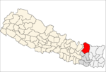
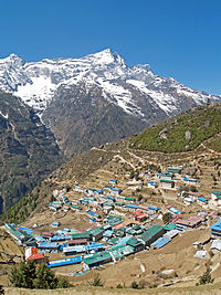
Namche Bazaar — Village Development Committee — Namche Bazaar with Kongde Ri peak in the background. Location in Nepal Coordinates: 27°49′N 86°43′E / 27.817°N 86.717°ECoordinates: 27°49′N 86°43′E / 27.817°N 86.717°E Country  Nepal
NepalZone Sagarmatha Zone District Solukhumbu District Elevation 3,440 m (11,286 ft) Population (1991) - Total 1,647 Time zone Nepal Time (UTC+5:45) Namche Bazaar (also Nemche Bazaar or Namche Baza; Nepali: नाम्चे बजार
 listen (help·info)) is a village and Village Development Committee (Namche) in Solukhumbu District in the Sagarmatha Zone of north-eastern Nepal. It is located within the Khumbu area at 3,440 metres (11,286 ft) (the low point that is), populating the sides of a hill. Namche is the main trading center for the Khumbu region with many Nepalese officials, a police check, post and a bank.
At the time of the 2001 Nepal census it had a population of 1647 people residing in 397 individual households.[1]
Contents
Geography
Immediately west of Namche is Kongde Ri at 6,187 metres (20,299 ft) and to the east is Thamserku at 6,623 metres (21,729 ft). Namche has a permanent population of around 800.
Transport
On a hill overlooking Namche Bazaar is the Syanboche Airport (3,750m / 12,303 ft). This airstrip is still in use, but mainly in the mornings when the weather conditions are more stable. Pilatus PC-6 Porter planes can be chartered to Lukla, a 5 minute flight, for around $US500.
Tourism
Namche Bazaar is popular with trekkers in the Khumbu region, especially for altitude acclimatization, and is the gateway to the high Himalaya. The town has a number of lodgings and stores catering to the needs of visitors as well as a number of internet cafés, making it one of the few places in the region where trekkers can access the internet.
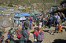
On Saturday mornings, a weekly market is held in the center of the village while there may also be a daily Tibetan market where clothing and cheap Chinese consumer goods tend to be the main articles for sale.
Climate
Namche has cool, wet summers and chilly, dry winters mainly affected by its altitude and the summer monsoon season.
Climate data for Namche Bazaar Month Jan Feb Mar Apr May Jun Jul Aug Sep Oct Nov Dec Year Average high °C (°F) 7
(45)6
(43)9
(48)12
(54)14
(57)15
(59)16
(61)16
(61)15
(59)12
(54)9
(48)7
(45)11 Average low °C (°F) −8
(18)−6
(21)−3
(27)1
(34)4
(39)6
(43)8
(46)8
(46)6
(43)2
(36)3
(37)−6
(21)1 Precipitation mm (inches) 26
(1.02)23
(0.91)34
(1.34)26
(1.02)41
(1.61)140
(5.51)243
(9.57)243
(9.57)165
(6.5)78
(3.07)9
(0.35)39
(1.54)1,067
(42.01)Source: thamel.com[2] Gallery
References
- ^ "Nepal Census 2001". Nepal's Village Development Committees. Digital Himalaya. http://www.digitalhimalaya.com/collections/nepalcensus/form.php?selection=1. Retrieved November 14, 2008.
- ^ "Climatological Data for Selected Trekking Towns". thamel.com. http://www.thamel.com/htms/climatological_Data.htm. Retrieved November 13, 2003.
External links
- Hiking Namche and Everest, GoNOMAD feature article
- Namche Bazaar travel guide from Wikitravel
- Image of Shrine at Namche Bazar
Bafa, Baku, Basa, Beni, Bhakanje, Bung, Chaulakharka, Chaurikharka, Chheskam, Deusa, Garma, Goli, Gorakhani, Gudel, Jubing, Jubu, Kaku, Kangel, Kerung, Khumjung, Kunde, Loding Tamakhani, Lokhim, Mabe, Mukali, Namche, Necha Batase, Necha Bedghari, Nele, Panchan, Salyan, Sautang, Takasindu, Tapting, Tingla Tapting Sherpa KyidugCategories:
- Populated places in Solukhumbu District
- Tourism in Nepal
Wikimedia Foundation. 2010.


