Durgerdam

Durgerdam
Durgerdam
—  Village  —
Durgerdam
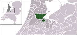
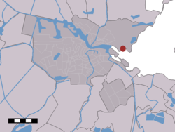
Durgerdam in the municipality of Amsterdam.
Coordinates: 52°23′N 4°59′E / 52.383°N 4.983°E / 52.383; 4.983Coordinates: 52°23′N 4°59′E / 52.383°N 4.983°E / 52.383; 4.983
Country Netherlands
Province Noord-Holland
Municipality Amsterdam
Time zone CET (UTC+1)
 - Summer (DST) CEST (UTC+2)
Postal code

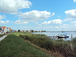
Durgerdam is a village in the Dutch province of North Holland. It is a part of the municipality of Amsterdam, and lies about 7 km east of the city centre, along the dyke of the IJsselmeer.

Durgerdam is a part of the deelgemeente (sub-municipality) Amsterdam-Noord. The village has about 430 inhabitants.[1]

Durgerdam was a separate municipality between 1 May 1817, and 1 January 1818, when it was merged with Ransdorp.[2]

Durgerdam hosted the 2nd pit-stop in The Amazing Race 12, a reality television show that circles the globe.

References

  1. ^ Statistics Netherlands (CBS), Kerncijfers postcodegebieden 2004 [1]: postcode 1026BX, BZ, CA to CM.
  2. ^ Ad van der Meer and Onno Boonstra, Repertorium van Nederlandse gemeenten, KNAW, 2006.


Wikimedia Foundation. 2010.

Игры ⚽ Нужен реферат?

Look at other dictionaries:

  • Durgerdam — in the municipality of Amsterdam. Durgerdam es …   Wikipédia en Français

  • Amsterdam Noord — (Amsterdam Nord) ist ein Stadtbezirk der Gemeinde Amsterdam in der Provinz Nordholland mit einer Einwohnerzahl von rund 87.000 (Stand: Januar 2010).[1] Die Grundfläche beträgt 64 km². Zusammen mit Osdorp wurde der Bezirk am 1. Dezember 1981 ein… …   Deutsch Wikipedia

  • Goudriaankanaal — Waterland Oost, mit dem Goudriaankanaal Der Goudriaankanaal sollte eine Verbindung zwischen Amsterdam und der Zuidersee bilden, und von Marken nach Ijdoorn (Durgerdam) führen. 1826 wurde mit den Bauarbeiten begonnen und 1828 wieder eingestellt.… …   Deutsch Wikipedia

  • Anciennes communes de la Hollande-Septentrionale — En 1812, la province néerlandaise de la Hollande Septentrionale comptait 111 communes. En 2011, il n y en avait plus que 60. Sommaire 1 Étapes principales des fusions 2 Liste des fusions des communes de la Hollande Septentrionale 2 …   Wikipédia en Français

  • Ransdorp — Dutch town locator maps mun town caption = Ransdorp in the municipality of Amsterdam.Ransdorp (coord|52|24|N|5|0|E|type:city(245)) is a village in the Dutch province of North Holland. It is a part of the municipality of Amsterdam, and lies about… …   Wikipedia

  • Buikslotermeer — (deutsch: Buikslotersee) ist ein ehemaliger See, der um 1627 trockengelegt wurde und nun ein Stadtviertel in Amsterdam Noord (Provinz Nordholland) ist. 2010 hatte das Viertel 11.580 Einwohner[1] …   Deutsch Wikipedia

  • Stadtteile von Amsterdam — Die Stadtteile von Amsterdam haben sich mit der neuen Einteilung der Stadtbezirke von Amsterdam (Mai 2010) ebenfalls geändert. Die heutigen sieben Stadtbezirke der Gemeinde Amsterdam (ohne das Gewerbegebiet Westpoort) sind aufgeteilt in 97… …   Deutsch Wikipedia

  • Claes Cornelisz. Moeyaert — Joseph trouve de l argent dans les sacs de Benjamin , Claes Moeyaert, 1627 Sur les autres projets Wikimedia : « Claes Cornelisz. Moeyaert », sur Wik …   Wikipédia en Français

  • Amsterdam — This article is about the Dutch capital. For other uses, see Amsterdam (disambiguation). Amsterdam   Municipality/city   From left to right and top to bot …   Wikipedia

  • Muiden —   Municipality   …   Wikipedia

Share the article and excerpts

Direct link
Do a right-click on the link above
and select “Copy Link”