- Mavrovo (region)
-
Mavrovo National Park 
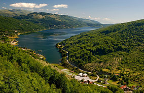
Panoramic image of Mavrovo in SummerCoordinates 41°41′N 20°42′E / 41.683°N 20.7°ECoordinates: 41°41′N 20°42′E / 41.683°N 20.7°E Area 73,088 hectares (730.88 km2) Established 19 April 1949 Official website Mavrovo (Macedonian: Маврово [ˈmavrɔvɔ] (
 listen)) is a region in the northwest of the Republic of Macedonia. It is home to Mavrovo National Park and a winter sports center. Some of the villages and smaller hamlets include: Mavrovo, Nikiforovo, Leunovo, and Mavrovi Anovi. This micro region is named Mavrovo because most of the people live in the village of Mavrovo and the more famous families were also from Mavrovo.
The region's location at Bistra mountain and the Lake Mavrovo have helped it grow into a year-round tourist center. Mavrovo is the most popular ski center in Macedonia.
The ski center named Zare Lazareski has two double lift chairs, one single lift chair with over 1100 person capacity per hour, several ski lifts with synchronized connection and over 5000 person capacity per hour. The ski center was renovated recently, so the capacity of the ski lifts and the ski chairs is increased. The ski trails start at 1960m and end at 1250m above sea level. There are plans to build a ski jumping facility in Macedonia, possibly Mavrovo.[1]
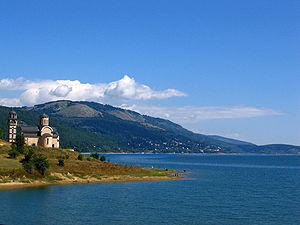
The Mavrovo lake lies at an altitude of 1220m. and its foundation began in 1953. It is 12 kilometers long and 3 kilometers wide and covers an area of 13,3 square kilometers. The coast is 24 kilometers long. The deepest measured spot of the lake is 48 meters deep. There is a lot of fish such as: trout, minnows etc... Lots of fishermen come to fish at Mavrovo lake during the weekend.
External links
Galičica · Mavrovo · Pelister
Categories:- IUCN Category II
- Geography of the Republic of Macedonia
- National parks of the Republic of Macedonia
- Republic of Macedonia geography stubs
Wikimedia Foundation. 2010.


