Dunragit

Dunragit
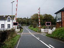
Level crossing at Dunragit

Dunragit (Gaelic: Dùn Reicheit) is a village on the A75, between Stranraer and Glenluce in Dumfries and Galloway (previously Wigtownshire) in south-west Scotland. It grew up around the west gate of Dunragit House, an 18th century three-storey four-bay country house. It expanded considerably in the 1950s. The major employer was always the Creamery, but this is no longer in use.

There is a possible Roman cremation cemetery and two castle mottes in the village. A pit defined cursus monument, dating from Neolithic and Bronze Age times, has also recently been excavated there. It was first discovered by aerial photography in 1992.

The place-name has, not uncontroversially, been said to derive from Din Rheged meaning Fort of Rheged. This would refer to the Brythonic Dark Age kingdom of Rheged that seems to have existed somewhere in this area of the English/Scottish border between the 5th and 8th centuries. It is possible that this was one of the royal sites used by the kings of Rheged and it has been suggested as the site of the unidentified Northern Royal court Penrhyn Rhionedd, recorded in the Welsh Triads.

Inspired by the Logan Botanic Garden and Tresco on the Isles of Scilly, the 12-acre (49,000 m2) Glenwhan Garden has been created in Dunragit, since 1979, out of a gorse and bracken covered hillside. It is open to the public.

External links

Coordinates: 54°52′44″N 4°53′06″W / 54.879°N 4.885°W / 54.879; -4.885


Wikimedia Foundation. 2010.

Игры ⚽ Поможем написать реферат

Look at other dictionaries:

  • Glasgow and South Western Railway — Infobox SG rail railroad name = Glasgow and South Western Railway logo filename = GSWR logo.png logo size = system map caption = map size = marks = image size = image caption = locale = Scotland start year = 1850 end year = 1923 predecessor line …   Wikipedia

  • Rheged — Das nördliche Britannien im 6. Jahrhundert Rheged war ein keltisches Königreich im frühmittelalterlichen Britannien. In der Dichtung wird es als zum sogenannten Hen Ogledd (walisisch für Alter Norden) gezählt. Die Bewohner Rhegeds sprachen… …   Deutsch Wikipedia

  • Rheged — [Welsh IPA: r̥ɛgɛd] was a Brythonic kingdom of Sub Roman Britain, whose inhabitants spoke Cumbric, a dialect of Brythonic closely related to Old Welsh. [Jackson, Language History in Early Britain , p. 9] It was situated in what is now north… …   Wikipedia

  • Stranraer — infobox UK place country = Scotland official name=Stranraer gaelic name=An t Sròn Reamhar scots name= population=10,851 (2001 Census) os grid reference=NX055605 map type= latitude=54.84504 longitude= 5.12429 unitary scotland=Dumfries and Galloway …   Wikipedia

  • British toponymy — is the study of British place names, their origins and trends in naming. Toponymy is distinct from the study of etymology, which is concerned mainly with the origin of the words themselves.British toponymy is rich, complex and diverse. Modern… …   Wikipedia

  • Cumbric language — Cumbric Spoken in Southern Scotland, Cumberland, Westmorland parts of Northumberland, Lancashire and possibly North Yorkshire Extinct 11th–12th century[1] …   Wikipedia

  • Galloway — (Gaelic: Gall Ghaidhealaibh , pronounced|əŋ ɡauɫ̪ɣəɫ̪əv or Gallobha , Lowland Scots Gallowa ) is an area in southwestern Scotland. It usually refers to the former counties of Wigtown (or historically West Galloway) and Kirkcudbright (or… …   Wikipedia

  • Portpatrick and Wigtownshire Joint Railway — [v · d · …   Wikipedia

  • Cynfarch Oer — (also known as Cunomarcus or Cynfarch ap Meirchion) was probably a 6th century king of the Sub Roman realm of Rheged, believed to be located in north west England and south west Scotland. Next to nothing is known about Cynfarch. He appears in the …   Wikipedia

  • Girvan and Portpatrick Junction Railway — [v · d · …   Wikipedia

Share the article and excerpts

Direct link
Do a right-click on the link above
and select “Copy Link”