- Nordwalde
-
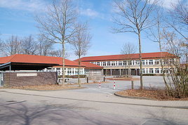
Nordwalde Elementary School in Nordwalde 
Coordinates 52°05′0″N 7°29′0″E / 52.083333°N 7.483333°ECoordinates: 52°05′0″N 7°29′0″E / 52.083333°N 7.483333°E Administration Country Germany State North Rhine-Westphalia Admin. region Münster District Steinfurt Town subdivisions 6 Mayor Sonja Schemmann (CDU) Basic statistics Area 51 km2 (20 sq mi) Elevation 55 m (180 ft) Population 9,373 (31 December 2010)[1] - Density 184 /km2 (476 /sq mi) Other information Time zone CET/CEST (UTC+1/+2) Licence plate ST Postal code 48356 Area code 02573 Website www.nordwalde.de Nordwalde (literally: north woods) is a municipality in the district of Steinfurt, in North Rhine-Westphalia, Germany.
Contents
Geography
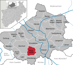
It is situated in the Münsterland area, approximately 12 km south-east of Steinfurt and 20 km north-west of Münster. The distance to the Dutch border is about 30 km.
Neighbouring municipalities
Division of the town
Nordewalde consists of 6 districts:
- Nordwalde
- Feldbauerschaft
- Kirchbauerschaft
- Scheddebrock
- Suttorf
- Westerode
Twin towns
 Amilly, France
 Treuenbrietzen, Germany
References
- ^ "Amtliche Bevölkerungszahlen" (in German). Landesbetrieb Information und Technik NRW. 31 December 2010. http://www.it.nrw.de/statistik/a/daten/amtlichebevoelkerungszahlen/index.html.
External links
- Official site (German)
Altenberge · Emsdetten · Greven · Hopsten · Hörstel · Horstmar · Ibbenbüren · Ladbergen · Laer · Lengerich · Lienen · Lotte · Metelen · Mettingen · Neuenkirchen · Nordwalde · Ochtrup · Recke · Rheine · Saerbeck · Steinfurt · Tecklenburg · Westerkappeln · Wettringen
Categories:- Towns in North Rhine-Westphalia
- North Rhine-Westphalia geography stubs
Wikimedia Foundation. 2010.


