- River Garnock
Geobox River
name = River Garnock
map_size =
map_caption =
other_name =
other_name1 =
country = Scotland
country1 =
region = North Ayrshire
region1 =
city =
city1 =
city2 =
city3 =
city4 =
length = 39
length_imperial =
watershed =
watershed_imperial =
discharge_location =
discharge_average =
discharge_average_imperial =
discharge_max_month =
discharge_max =
discharge_max_imperial =
discharge_min_month =
discharge_min =
discharge_min_imperial =
discharge1_location =
discharge1_average =
discharge1_average_imperial =
discharge2_location =
discharge2_average =
discharge2_average_imperial =
discharge3_location =
discharge3_average =
discharge3_average_imperial =
discharge4_location =
discharge4_average =
discharge4_average_imperial =source_name =
source_location = Hill of Stake
source_region = Ayrshire
source_country = Scotland
source_country1 =
source_elevation = 522
source_elevation_imperial =
source_lat_d =
source_lat_m =
source_lat_s =
source_lat_NS =
source_long_d =
source_long_m =
source_long_s =
source_long_EW =
mouth_name =
mouth_location = Firth of Clyde
mouth_country =
mouth_region = Irvine
mouth_country1 =
mouth_elevation =
mouth_elevation_imperial =
mouth_lat_d =
mouth_lat_m =
mouth_lat_s =
mouth_lat_NS =
mouth_long_d =
mouth_long_m =
mouth_long_s =
mouth_long_EW =
tributary_left =
tributary_left1 =
tributary_right =
tributary_right1 =
image_size =
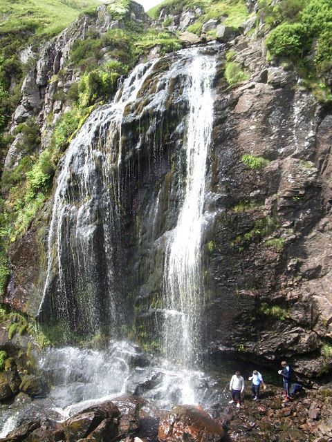
image_caption = "The Spout"The River Garnock, the smallest of
Ayrshire 's six principal rivers [ [http://www.ayrshireriverstrust.org/garnock.htm Ayrshire Rivers Trust, River Garnock] ] , has its source on the southerly side of the Hill of Stake in the heart of theClyde Muirshiel Regional Park . About a mile and a half south of this starting point the untested stream tumbles over TheSpout of Garnock , [http://www.geograph.org.uk/photo/475878] , the highest waterfall in Ayrshire, once thought to be the river's origin. The river then continues, for a total length of 20 miles or so, through the towns ofKilbirnie ,Glengarnock , Dalry andKilwinning to its confluence with theRiver Irvine at Irvine Harbour.Main tributaries are the Rye Water and Caaf Water which join north and south of Dalry respectively and the Lugton Water which joins just south of Kilwinning.
Garnock Valley
"
Glen Garnock" pertains specifically to the short, sometimes precipitous, section of ravine overlooked by the ruins ofGlengarnock Castle north of Kilbirnie, whereas "TheGarnock Valley " refers to a wider geographic area ofNorth Ayrshire abuttingRenfrewshire , which encompassees the former parishes ofBeith ,Dalry , andKilbirnie .Estuary
Within Ayrshire by far the largest
estuary has developed, behind the Ardeer Peninsula, at the confluence of the Irvine and Garnock Rivers. This is one of the best examples of a bar-built estuary in the UK and is the only major estuary between the Solway and Inner Clyde. The majority of the estuary has been designated aSSSI , in recognition of its national importance for three bird species (eider, red-breasted merganser and goldeneye). It is also a nationally important feeding ground for thousands of migrating birds during the spring and autumn. Otters and water voles live on the estuary as well as numerous breeding birds, including water rail, grasshopper warbler and sand martin. The Garnock/Irvine estuary is also a Wildlife Site. [ [http://www.south-ayrshire.gov.uk/community/LBAP/publications/coastal.pdf Ayrshire Biodiversity Action Plan, Coastal and Marine Habitats] ]Bogside Flats SSSI covers 253.8ha that include inter-tidal mudflats, salt-marsh and adjacent pasture land. [Scottish Natural Heritage Commissioned Report No. 038, October 2002]
* [http://www.boatjumbleassociation.co.uk/Irvine-Harbour.jpgAerial photograph of the Estuary, Irvine Harbour and Bogside Flats (2000)]
Places of Interest
*
Clyde Muirshiel Regional Park is the source of the headwaters of the Garnock.
*Spout of Garnock is the highest waterfall in Ayrshire.
*Glengarnock Castle is a ruined keep standing on a remote rocky promontory overlooking the river, located about 2 miles north of Kilbirnie.
*Nether Mill [ [http://www.ayrshirehistory.org.uk/Bibliography/hume.htm#Kilbirnie Hume, John R., The Industrial Archaeology of Scotland (1976)] ] (or Nethermyln), in Kilbirnie, is a ruinedwatermill that leaves as its legacy the name of the local football team,Kilbirnie Ladeside , who originally played in a field beside the mill lade running from aweir on the river to the mill at the end of Knoxville Road.
*Dalgarven Mill still draws water from the Garnock to turn the restored undershotwaterwheel . The mill complex, located off the A737 road north of Kilwinning, is now a tourist attraction with the mill building being home to theMuseum of Ayrshire Country Life and Costume .
* [http://www.geograph.org.uk/photo/50554 Kilwinning Viaduct] , on the formerLanarkshire and Ayrshire Railway , is now used by theSustrans Garnock Valley Cycleway [ [http://www.sustrans.org.uk/default.asp?sID=1100190817437 Garnock Valley Cycleway] ] to get across the river.
*Eglinton Country Park was developed around the ancient Eglinton Estate, home for 600 years to the Earls of Eglinton and Winton.
*Salmon generally arrive in the Garnock at the end of July, with the most productive part of the river being the stretch between Kilbirnie and Dalry. [ [http://www.trout-salmon-fishing.com/scotland-river-irvine.htm Trout and Salmon Fishing] ]
*Garnock Floods is a wildlife reserve of the [http://www.swt.org.uk/ Scottish Wildlife Trust] in Kilwinning; sandwiched between the railway line, Sandy Road and the river. [ [http://www.swt.org.uk/wildlife/popup_reserves/west/garnock.htm SWT Garnock Floods, Kilwinning] ]
* Ardeer Factory, once the world's largest commercial explosives factory, is situated on a natural peninsula with the Firth of Clyde on its west side, the River Garnock to the east, and the mouth of the River Irvine to the south. [ [http://nobelprize.org/alfred_nobel/industrial/articles/dolan/index.html Nobel in Scotland by John E. Dolan] ]Tributaries
Pundeavon Burn
:"Confluence from the right at Coordinates :" coord|55|45|23|N|4|41|08|WThe Pundeavon Burn drains from [http://www.geograph.org.uk/photo/173144 Pundeavon Reservoir] and enters the Garnock just upstream of Kilbirnie Cross.
Paduff Burn
:"Confluence from the right at Coordinates :" coord|55|45|13|N|4|41|08|WThe Paduff Burn is a small stream, known locally as Jock's Burn, which comes into play on the golf course at Kilbirnie Place Golf Club:
Jocks Burn comes in to play at the first 2 holes (Padduff and Place Brae), a short par 3 and then a par 4. The 2nd requires to carry the burn onto an elevated fairway with out of bounds on your right. [http://www.kilbirnieplacegolfclub.co.uk/ Kilbirnie Place Golf Club, The Course] ]
The final hole (Jock's Burn) is a short par 3 with a large Oak tree on the left which, if caught, could send your ball into Jocks Burn. With out of bounds on the right and immediately at the back, this a daunting last hole. [http://www.kilbirnieplacegolfclub.co.uk/ Kilbirnie Place Golf Club, The Course] ]
Powgree Burn
:"Confluence from the left at Coordinates :" coord|55|44|11|N|4|40|46|WThe Powgree Burn rises on Cuff hill [Dobie, James (1876). Pont's Cunninghame topographized 1604-1608 with continuations and illustrative notices (1876). Pub. John Tweed. P. 85.] in the
Gateside area, runs through Auchengree andLongbar then shortly after runs under [ [http://local.live.com/default.aspx?v=2&cp=55.7388~-4.6755&style=a&lvl=18 Powburn undern the Glengarnock Railway Station] ]Glengarnock railway station .Pitcon Burn
:"Confluence from the right at Coordinates :" coord|55|43|09|N|4|42|14|WThe Pitcon Burn cuts deep into the hillside causing the tree lined gully [ [http://www.geograph.org.uk/photo/155684 Geograph, Pitcon Burn] ] known as Swinlees Glen Dalry, Swinlees Glen; Report of excursion to, Glasgow Naturalist V (1913) 72.] , a Nature Conservation Site, and enters the Garnock near its namesake Pitcon House.
Putyan Burn
The Putyan Burn forms from a number of small burns, etc., such as the Baidland Burn from Baidland Hill and springs at Baidland Mill. It reaches its confluence with the Garnock at Putyan Cottage and the Lynn Holm, near the road junnction for Ardrossan at the Kilwinning end of the town. It passes Broadlie House where a small weir or dam still exists as part of an abandoned 1892 hydroelectric scheme which provided the house with its own electricity.http://www.ayrshirepaths.org.uk/walkdalry.htm Broadlie House.]
Rye Water
:"Confluence from the right at Coordinates :" coord|55|42|42|N|4|42|28|WThe Rye Water drains from the area of Muirhead Reservoir and [http://www.geograph.org.uk/photo/48733 Camphill Reservoir] and runs through [http://www.geograph.org.uk/photo/88126 Drakemyre] to join the Garnock north of Dalry near Brownhill Junction on the main railway line.
Caaf Water
:"Confluence from the right at Coordinates :" coord|55|41|52|N|4|42|50|WThe Caaf Water drains from Caaf Reservoir [ [http://www.geo.ed.ac.uk/scotgaz/features/featurefirst3309.html Gazeteer for Scotland, Caaf Water] ] and soon passes the
Michelin star rated Braidwoods Restaurant, housed in two simple cottages in the midst of a distinctly rural setting [ [http://www.restaurant-guide.com/braidwoods-restaurant.htm Restaurant Guide, Braidwoods] ] , before entering the Lynn Glen with its picturesque waterfall [ [http://www.north-ayrshire.gov.uk/na/DevelopProm.nsf/36e3faebea4c5c2280256e82002f5ea4/db8db18ee2c5f18180256f710047cfe1/$FILE/Dalry%20Walks.pdf North Ayrshire Council, Lynn Glen Walk] ] and finally enters the Garnock south of Dalry.Bombo Burn
:"Confluence from the left at Coordinates :" coord|55|41|28|N|4|42|34|WThe Bombo Burn is a small stream, only about 5 miles in length, that runs across the north side of Bankhead Moss, a Special Area of Conservation [ [http://www.jncc.gov.uk/ProtectedSites/SACselection/sac.asp?EUCode=UK0019756 Joint Nature Conservation Committee, Bankhead Moss, Beith] ] and joins the Garnock soon after passing through the Blair Estate:
The delightfully landscaped grounds and gardens of the Estate contain a wonderful mixture of species trees and shrubs from all over the world. The Bombo Burn meanders gently for a mile through the gardens creating many natural beauty spots. The ancient yew tree recorded in the "
Domesday Book " leans over the banks of the Bombo Burn presiding on the changes over the centuries. [ [http://www.blairestate.com/house.htm Blair House, Grounds and Gardens] ]Dusk Water
:"Confluence from the left at Coordinates :" coord|55|40|49|N|4|42|44|WThe Dusk Water is a stream that has its beginnings on Cuff Hill, near
Beith , and runs throughBarrmill to eventually join the Garnock upstream of Dalgarven.Interesting places along its course, as well as several old watermills, are Giffin House, a large and handsome mansion-house, and Cleeves Cove, a system of caves in the Dusk Glen.
Mills
*Coldstream Mill is located on the south side of Cuff Hill. The grain mill can still operate today, albeit only for demonstration purposes, [ [http://www.beith.com/Beith%20News%20HTML%20Files/Beith%20News%2010.htm Beith News] ] with water supplied from the scenic mill dam.
* Giffen Mill (or Barr Mill) is a ruined grain mill in the village ofBarrmill .
*Blair Mill was a traditional corn mill for the large Blair estate in Dalry. It was probably built in the late 18th century and ceased to be used as a mill in the 1950s. [ [http://www.workinglives.org.uk/show_item.asp?int_category=2&int_sub_category=4&int_sub_sub_category=6&int_item_id=267 Ayrshire Libraries Forum] ]
*Waterside Mill, lying downstream of the Dusk Glen, is now a residence.Lugton Water
:"Confluence from the left at Coordinates :" coord|55|38|35|N|4|41|08|WThe Lugton Water, the largest tributary of the Garnock, runs 14 miles from Loch Libo (395 feet above sea-level) in
Uplawmoor , throughLugton and the parishes of Neilston, Beith, Dunlop, Stewarton and Kilwinning. The Lugton joins the Garnock below the tidal limit, shortly after passing throughEglinton Country Park , developed around the ancient estate of the Earl of Eglinton.The Duniflat Burn joins the Lugton Water from the East Ayrshire side close to the North Biggart bridge near where the Bells Burn from Bells Bog on the East Renfrewshire side also has its confluence.
Pont refers to it as the 'Ludgar' or 'Lugdurr'Dobie, James D. (ed Dobie, J.S.) (1876). "Cunninghame, Topographized by Timothy Pont" 1604–1608, with continuations and illustrative notices. Pub. John Tweed, Glasgow. P. 313.] . Loch Libo in the 14th century was referred to as "Loch le Bog Syde" in a charter, meaning the "Bogside Loch".Paterson, James (1863-66). History of the Counties of Ayr and Wigton. V. III - Cunninghame. J. Stillie. Edinburgh. P. 215.]
River Irvine
:"Confluence at Coordinates :" coord|55|26|38|N|4|41|23|WThe two main rivers of North Ayrshire, the Irvine and the Garnock, come together in the estuary at Irvine Harbour where they jointly enter the
Firth of Clyde .Major tributaries of the Irvine are the Glen Water, Cessnock Water, Kilmarnock Water (combined Fenwick and Craufurdland Waters), Carmel Water and Annick Water.
Picture Gallery
Cleeves Cove and Dusk Water
Dalgarven Mill and views of the Garnock
External links
[http://www.ayrshireriverstrust.org Ayrshire Rivers Trust]
References
Wikimedia Foundation. 2010.