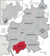
- Dahlem, North Rhine-Westphalia
-
Dahlem 
Coordinates 50°22′59″N 6°32′59″E / 50.38306°N 6.54972°ECoordinates: 50°22′59″N 6°32′59″E / 50.38306°N 6.54972°E Administration Country Germany State North Rhine-Westphalia Admin. region Cologne District Euskirchen Mayor Reinhold Müller (CDU) Basic statistics Area 95.18 km2 (36.75 sq mi) Elevation 539 m (1768 ft) Population 4,116 (31 December 2010)[1] - Density 43 /km2 (112 /sq mi) Other information Time zone CET/CEST (UTC+1/+2) Licence plate EU Postal code 53949 Area code 02447 Website www.dahlem.de "Kronenburg" redirects here. For other places, see Kronenberg (disambiguation).Dahlem is a municipality in the district of Euskirchen in the state of North Rhine-Westphalia, Germany. It is located in the Eifel hills, approx. 35 km south-west of Euskirchen. The small medieval town Kronenburg is part of the municipality.
References
- ^ "Amtliche Bevölkerungszahlen" (in German). Landesbetrieb Information und Technik NRW. 31 December 2010. http://www.it.nrw.de/statistik/a/daten/amtlichebevoelkerungszahlen/index.html.
Bad Münstereifel | Blankenheim | Dahlem | Euskirchen | Hellenthal | Kall | Mechernich | Nettersheim | Schleiden | Weilerswist | ZülpichCategories:- Municipalities in North Rhine-Westphalia
- North Rhine-Westphalia geography stubs
Wikimedia Foundation. 2010.


