- Ardeşen
Infobox Settlement
settlement_type = Town
subdivision_type = Country
subdivision_name = TUR
timezone=EET
utc_offset=+2
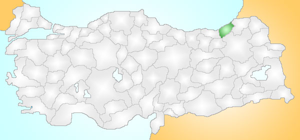
map_caption =Location of PAGENAME within Turkey.
timezone_DST=EEST
utc_offset_DST=+3official_name = Ardeşen

image_caption =
image_blank_emblem =
blank_emblem_type =
subdivision_type1=Region
subdivision_name1 = Black Sea
subdivision_type2=Province
subdivision_name2 = Rize| population_total = 58499|population_footnotes=
population_as_of =| 2000
population_density_km2 =
area_total_km2 = 743|elevation_m =
latd = 41
latm = 11
lats = 22
longd = 40
longm = 49
longs = 37
longEW=E
latNS=N
postal_code_type=Postal code
postal_code = 53
area_code = (0090)+ 464
leader_title=Mayor
leader_name = Mümtaz Sinan
blank_info = 53|blank_name=Licence plate
website = http://www.ardesen.bel.trArdeşen (Laz: "Artaşen") is a town and district of
Rize Province in the Black Sea region ofTurkey , 48km along the coast road from the city ofRize .History
See
Rize Province for the history of the area, at one time part of the Roman andByzantine Empire s and later theEmpire of Trebizond until their defeat in 1461 by the Ottoman SultanMehmet II .Geography
Ardeşen is sandwiched between sea and mountain, with 10km of
Black Sea coastline, while most of the district is hill and mountain, extending 50km inland, up to theAltıparmak hills and then on toÇamlıhemşin and theKaçkar mountains. There is plenty of rainfall but little land flat enough for planting anything except for tea, and life is hard in these wet highlands. The highland villages are remote, and reaching them with roads, cables and other infrastructure is very challenging.This was even more the case before tea planting began, when successive generations would migrate away from the area to jobs in Turkey's larger cities or abroad. 10% of the land is used for tea growing, other than is there is little agriculture except gardening for local consumption. The first tea-processing factory was opened in 1947, other industry includes sawmills and furniture workshops.
The industrial development is in the town of Ardeşen itself, which is on the coast near the mouth of the
Fırtına River. Ardeşen has too many ugly public buildings and apartment blocks. The busy coast road through Ardeşen leads up to Turkey's border withGeorgia (country) . The cuisine is the typical Turkish menu, based onkebab . Ardeşen has some local radio, TV and newspapersThe income from tea growing has brought better amenities to Ardeşen but the traditional rural lifestyle persists; many of the people in the countryside are ethnic
Laz and the older generations in particular continue to speak theLaz language although their traditional clothing has disappeared with the ban on growing hemp. However education is quite successful with literacy rates of 97% among men and 89% among women.The people of Ardeşen have a reputation for their love of firearms, most people carry them and home-made small arms are a thriving trade, (to such an extent that in 1991 the state established a factory here to produce them legally and try and bring the industry under control [cite web
title = ASİLSAN - ARDEŞEN SİLAH SANAYİİ
publisher = Asilsan Ardeşen Arms Industry
date =
url = http://www.rize.gov.tr/ardesen/Asilsan.htm
format =
accessdate = 2008-04-05] ). Even the municipality logo features a picture of a mosque and a revolver.Places of interest
*
Fırtına Deresi, a river running down from the Kaçkars, is used for rafting.References
External links
* [http://www.ardesen.gov.tr District governor's official website]
** [http://www.ardesen.gov.tr/ardesenresimleri/1/album0.html photos of Ardeşen]
* [http://www.ardesen.bel.tr Ardeşen municipality's official website]
** [http://ardesen.bel.tr/galeri/index_script.php?gal=resimler&page=1 and more photos]
* [http://www.lazuri.com Lazuri - information on the Laz language and culture]
* [http://www.ardesenim.com/ Ardeşenim - General local site on the district]
Wikimedia Foundation. 2010.
