Hassa, Turkey

Hassa, Turkey

Infobox Settlement

settlement_type = District
subdivision_type = Country
subdivision_name = TUR
timezone=EET
utc_offset=+2
map_caption =Location of PAGENAME within Turkey.
timezone_DST=EEST
utc_offset_DST=+3

official_name = Hassa


image_caption =
image_blank_emblem =
blank_emblem_type =


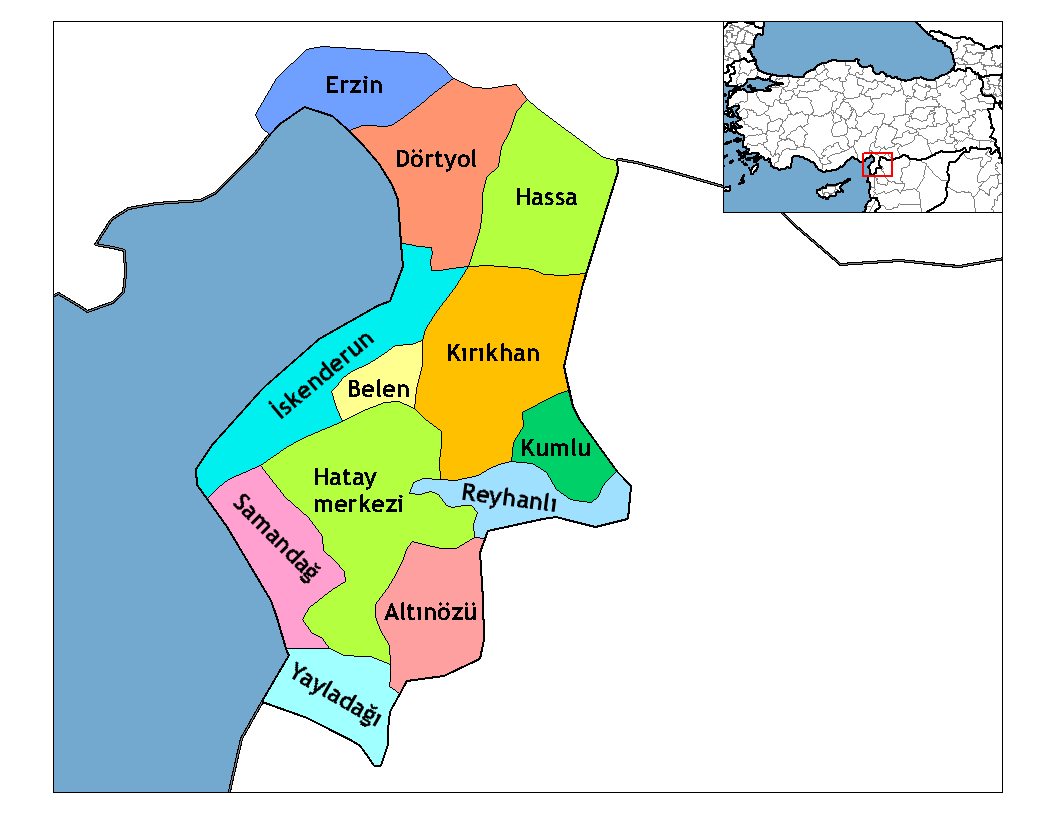
subdivision_type1=Region
subdivision_name1 = Mediterranean
subdivision_type2=Province
subdivision_name2 = Hatay| population_total =
population_urban =
population_as_of =
population_footnotes =
population_density_km2 =
area_total_km2 =
elevation_m = 430|postal_code_type=Postal code
postal_code = 31
blank_info = 31|blank_name=Licence plate
area_code = (0)326
leader_title=Mayor
leader_name = Selahattin KOCAMAN
website = http://www.hassa.bel.tr
leader_name1 =
gwebsite =

Hassa is a district of Hatay Province, Turkey on the eastern side of the Nur (Amanos) Mountains, looking towards the city of Gaziantep.

Hassa is an olive growing district. The trees were first brought here by Ottoman governor Derviş Paşa in the late 19th century.

External links

* [http://www.hassa.bel.tr/ Official website] tr icon


Wikimedia Foundation. 2010.

Игры ⚽ Нужен реферат?

Look at other dictionaries:

  • Hassa (Hatay) — Hassa Administration Pays …   Wikipédia en Français

  • List of cities in Turkey — The National Flag of Turkey This list is incomplete; you can help by expanding it. This is a list of cities in Turkey by population. Included are cities that are provincial capitals or have a population of at least 7,000 …   Wikipedia

  • Districts of Turkey — Republic of Turkey This article is part of the series: Politics and government of the Republic of Turkey …   Wikipedia

  • Districts de Turquie — Les 81 provinces de Turquie sont divisées en 923 districts (ilçeler; singulier: ilçe). Aux débuts de la République Turque comme dans l Empire ottoman, l unité correspondante était le kaza. Le district porte usuellement le même nom que la capitale …   Wikipédia en Français

  • Hatay Province — Infobox Province TR name=Hatay region=Mediterranean area=5,403 total population= 1,386,224 licence = 31 area code= 326| Hatay is a province of southern Turkey, on the Mediterranean coast, with Syria to the south and east.Geography46% of the land… …   Wikipedia

  • Ottoman Empire — دَوْلَتِ عَلِيّهٔ عُثمَانِیّه Devlet i Âliyye i Osmâniyye …   Wikipedia

  • Çukurova — This article is about a region in Turkey. For the district municipality in Adana, see Çukurova, Adana. Çukurova   Region   Location of Çukurova within Turkey …   Wikipedia

  • Hatay State — Infobox Former Country native name = Hatay Devleti لواء الإسكندرونة conventional long name = Hatay State common name = Hatay continent=moved from Category:Asia to the Middle East region= the Middle East country=Turkey era=Interwar period year… …   Wikipedia

  • Reyhanlı —   District   Location of Reyhanlı within Turkey. Coordinates …   Wikipedia

  • Nureddin Pasha — This article is about an Ottoman army officer. For an Ottoman grand vizier, see Abdurrahman Nureddin Pasha. Nureddin İbrahim (Konyar) 1309 (1893) P. 31 Miralay Nureddin Bey …   Wikipedia

Share the article and excerpts

Direct link
Do a right-click on the link above
and select “Copy Link”