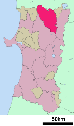
- Ōdate, Akita
-
Ōdate
大館市— City — 
FlagLocation of Ōdate in Akita Coordinates: 40°16′N 140°33′E / 40.267°N 140.55°ECoordinates: 40°16′N 140°33′E / 40.267°N 140.55°E Country Japan Region Tōhoku Prefecture Akita Government – Mayor Hajime Obata Area – Total 913.70 km2 (352.8 sq mi) Population (April 2011) – Total 77,703 – Density 85/km2 (220.3/sq mi) Time zone Japan Standard Time (UTC+9) City symbols - Tree Akita sugi - Flower Chrysanthemum Phone number 0186-49-3111 Address 20 Aza Nakajō, Ōdate-shi, Akita-ken
017-8555Website City of Ōdate Ōdate (大館市 Ōdate-shi) is a city located in Akita in Tōhoku region of Japan.
The city was founded on April 1, 1951.
As of 2003, the city had an estimated population of 65,090 and the density of 162.10 persons per km². The total area was 401.54 km².
On June 20, 2005, the towns of Hinai and Tashiro were merged into the city, increasing its population (as of 2011) to 77,703 and the area of the city to 913.70 km².
Odate-Noshiro Airport in nearby Kitaakita serves the city.
One of its local wares is Magewappa.
External links
- (Japanese) Odate official website
- (English) Odate travel guide from Wikitravel
 Akita Prefecture
Cities 
Kazuno District Kitaakita District Minamiakita District Ogachi District Semboku District Yamamoto District Categories:- Cities in Akita Prefecture
- Akita geography stubs
Wikimedia Foundation. 2010.


