- Gülşehir
Infobox Settlement
settlement_type = District
subdivision_type = Country
subdivision_name = TUR
subdivision_type1=Region
subdivision_name1 = Central Anatolia
subdivision_type2=Province
subdivision_name2 = Nevşehir
timezone= EET
utc_offset=+2
map_caption =Location of Gülşehir within Turkey.
timezone_DST=EEST
utc_offset_DST=+3
official_name = Gülşehir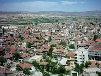
image_caption = A panorama of Gülşehir
image_blank_emblem =
blank_emblem_type =
population_total = 31664
population_urban = 9377
population_as_of = 2000
population_footnotes =
population_density_km2 = 33.12
area_total_km2 = 956
latd = 38
latm = 45
latNS = N
longd = 34
longm = 37
longEW = E
elevation_m = 885
postal_code_type=Postal code
postal_code = 50xxx
area_code = 0384
blank_info = 50
blank_name=Licence plate
leader_title =Governor
leader_name = Süleyman Yıldırım
leader_title1 =Mayor
leader_name1 = Erol Ünlüsoy
website = [http://www.gulsehir.gov.tr/ www.gulsehir.gov.tr]Gülşehir, formerly Arapsun, ancient Zoropassos, is a town and district of
Nevşehir Province in the Central Anatolia region ofTurkey , in the vicinity of the Fairy Chimney valley ofGöreme . According to 2000 census, population of the district is 31,664 of which 9,377 live in the town of Gülşehir, and the remainder in surrounding villages.cite web|url=http://www.die.gov.tr/nufus_sayimi/2000tablo5.xls|title=Census 2000, Key statistics for urban areas of Turkey|accessdate=2008-04-09|author=Turkish Statistical Institute |format=XLS|language=Turkish] [cite web|url=http://www.xist.org/cntry/turkey.aspx?levels=Ic%20Anadolu|title=Statistical information on Turkey's administrative units|accessdate=2008-04-09|author=GeoHive|language=English] The district covers an area of convert|956|km2|sqmi|0|abbr=on, [cite web|url=http://www.statoids.com/ytr.html|title=Statistical information on districts of Turkey|accessdate=2008-04-12|author=Statoids|language=English] and the average elevation is convert|885|m|ft|0|abbr=on.History
The old name of Gülşehir, situated on the southern bank of the
Kızıl River , 20 km from Nevşehir, is Arapsun and in ancient times it was called “Zoropassos” by theHittites . In the vicinity of Gülşehir there are still rocks and steles with inscriptions from the Hittites.The Ottoman Grand Vizier Karavezir Mehmet Seyyid Pasha did the same thing in Gülşehir as
Damat İbrahim Pasha did in the nearbyNevşehir and akülliye was built in the town which had only 30 houses. The complex consisted of a mosque, amadrasah and a fountain.The
pottery , located completely inside an artificial cave deep in the rock, is a local tourist attraction.ee also
*
Cappadocia Notes
References
*
*External links
* [http://www.gulsehir.gov.tr/ District governor's official website] tr icon
* [http://www.nevsehir.gov.tr/resimler/harita/gulsehir.jpgMap of Gülşehir district]
* [http://www.nevsehirozelidare.gov.tr/harita/gulsehir.jpgAdministrative map of Gülşehir district]
Wikimedia Foundation. 2010.