- Olympia Airport
Infobox Airport
name = Olympia Airport
nativename = Olympia Regional Airport
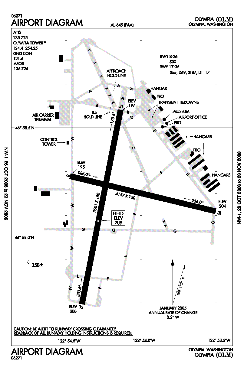
image-width = 150
caption = FAA airport diagram
IATA = OLM
ICAO = KOLM
FAA = OLM
type = Public
owner = Port of Olympia
operator =
city-served =Olympia, Washington
location =Tumwater, Washington
elevation-f = 209
elevation-m = 64
coordinates = coord|46|58|10|N|122|54|09|W|type:airport|display=inline
website = [http://www.portolympia.com/airport www.PortOlympia.com/airport]
r1-number = 8/26
r1-length-f = 4,157
r1-length-m = 1,267
r1-surface =Asphalt
r2-number = 17/35
r2-length-f = 5,501
r2-length-m = 1,677
r2-surface = Asphalt
stat-year = 2006
stat1-header = Aircraft operations
stat1-data = 74,796
stat2-header = Based aircraft
stat2-data = 189
footnotes = Source:Federal Aviation Administration FAA-airport|ID=OLM|use=PU|own=PU|site=26327.*A, effective 2007-07-05]Olympia Airport Airport codes|OLM|KOLM|OLM, also known as Olympia Regional Airport, is a public
airport located four miles (6 km) south of thecentral business district of Olympia, a city in Thurston County and the capital of theU.S. state ofWashington . The airport is owned by the Port of Olympia. It is about one mile (1.6 km) east ofInterstate 5 , actually within the boundaries of the city of Tumwater which is south of and adjacent to Olympia. The airport has tworunway s, a passenger terminal, a FAAcontrol tower , and a full-instrument landing approach system.The field is home to flight instruction, both fixed wing and helicopter, major oxygen and aircraft maintenance facilities, the
Washington State Patrol aviation division, and a key navigational aid (Olympia VOR) for commercial flights inbound toSeattle-Tacoma International Airport and general aviation aircraft in the region. The airport averages 254 takeoffs or landings a day.The airport served as a satellite of nearby McChord Field (now AFB) during World War II, and commercial aviation history at the Olympia Airport extends to the 1920s. The airport now supports large corporate jets, cargo aircraft, military helicopters and has a back-up runway lighting system for uninterrupted operations. Olympia Airport also has an Instrument Landing System and backup power system for operations during bad weather or low visibility.
The airport is in the midst of a federally funded $15 million improvement project to make it a safer facility, including runway line-of-sight enhancements during summer of 2007. The project requires the closure of convert|3300|ft|m of runway 17-35 through September, 2007, making runway 8-26 (generally the crosswind runway) the primary runway.
The airport's
industrial park , convert|300|acre|km2 in extent, includes a U.S. Department of Commerce designatedFree Trade Zone .Olympic Flight Museum is located at the Olympia Airport, and Airlift Northwest, the region's air medical transport service uses the airport as one of itsmedical helicopter bases. The flight museum and the airport plays host to a moderate sized air show each June.Facilities and aircraft
Olympia Airport covers an area of 1,632
acre s (660 ha) which contains twoasphalt pavedrunway s: 8/26 measuring 4,157 x 150 ft (1,267 x 46 m) and 17/35: 5,501 x 150 ft (1,677 x 46 m).For the 12-month period ending December 31, 2006, the airport had 74,796 aircraft operations, an average of 204 per day: 96%
general aviation , 2%air taxi and 2% military. There are 189 aircraft based at this airport: 77% single engine, 6% multi-engine, 3% jet aircraft and 14%helicopter s.ee also
*
Washington World War II Army Airfields References
External links
* [http://www.portolympia.com/airport Olympia Regional Airport] at Port of Olympia web site
*
*
Wikimedia Foundation. 2010.