Magu District

Magu District
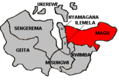
Map of Mwanza's Districts

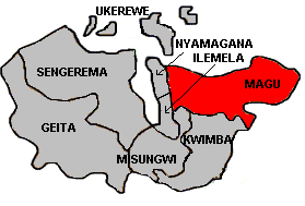
Magu District is one of the 8 districts of the Mwanza Region of Tanzania. It is bordered to the North by Lake Victoria, to the South by the Kwimba District, Misungwi District and the Shinyanga Region, to the East by the Shinyanga Region, and to the West by the city of Mwanza (Nyamagana District).

According to the 2002 Tanzania National Census, the population of Magu was 416,113. [1]

Wards

Magu District is administratively divided into 27 wards:

  • Badugu
  • Bujashi
  • Igalukilo
  • Kabita
  • Kahangara
  • Kalemela
  • Kiloleni
  • Kisesa
  • Kitongosima
  • Kongolo
  • Lubugu
  • Lutale
  • Magu Mjini
  • Malili
  • Mkula
  • Mwamabanza
  • Mwamanga
  • Mwamanyili
  • Ngasamo
  • Ng'haya
  • Nkungulu
  • Nyaluhande
  • Nyanguge
  • Nyigogo
  • Shigala
  • Shishani
  • Sukuma

Sources

Coordinates: 2°30′S 33°30′E / 2.5°S 33.5°E / -2.5; 33.5


Wikimedia Foundation. 2010.

Игры ⚽ Нужно решить контрольную?

Look at other dictionaries:

  • Magu District — Admin ASC 2 Code Orig. name Magu District Country and Admin Code TZ.12.155313 TZ …   World countries Adminstrative division ASC I-II

  • Magu — may refer to: Magu District of Mwanza Region, Tanzania Gilbert Magú Luján Magu, a Desorden Público band member. Ma Gu, a legendary Xian (Taoism) immortal This disambiguation page lists articles associated with the same title. If an …   Wikipedia

  • Nyamagana District — Map of Mwanza s Districts Nyamagana District is one of the eight districts of the Mwanza Region of Tanzania. It comprises the Northern half of the city of Mwanza. It is bordered to the North and West by Lake Victoria, to the South by the Ilemela… …   Wikipedia

  • Misungwi District — Map of Mwanza s Districts Misungwi District, Tanzania is located in the Mwanza Region on the shores of Lake Victoria. According to the 2002 Tanzanian National Census, the population is 256,133 with 20,604 of those residents living in an urban… …   Wikipedia

  • Kwimba District — is one of 8 districts of the Mwanza Region of Tanzania. It is bordered to the West by the Misungwi District and to the North by the Magu District. Kwimba s population is 316,180 (2002 TZ National Census). The district seat is at Ngudu.… …   Wikipedia

  • Community Development and Relief Agency — The Community Development and Relief Agency (CODRA) is a Non Governmental Organisation founded in 2001 to work with the poor or marginalised sections of society, to help them achieve sustainable socio economic growth. The Headquarters of CODRA is …   Wikipedia

  • Sukuma — ethnic group group = Sukuma poptime= popplace = Tanzania rels = langs = Sukuma related = NyamweziThe Sukuma is the largest ethnic groups in Tanzania, with an estimate 3.2 million members representing between 10 and 13 percent of the country s… …   Wikipedia

  • Nyalikungu — Magu or Nyalikungu in Kwimba District, Tanzania was a small settlement village on the southwest coast of Lake Victoria and an important trading post for tourists travelling from Mwanza to the Serengeti National Parks. Categories: Populated places …   Wikipedia

  • Mwanza — For other uses, see Mwanza (disambiguation). Mwanza Nyanza   City   View of Mwanza s Central Business District …   Wikipedia

  • Fuvahmulah — Island Summary Belongs to Gnaviyani Atoll Location …   Wikipedia

Share the article and excerpts

Direct link
Do a right-click on the link above
and select “Copy Link”