Misungwi District

Misungwi District
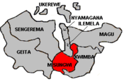
Map of Mwanza's Districts

Misungwi District, Tanzania is located in the Mwanza Region on the shores of Lake Victoria. According to the 2002 Tanzanian National Census, the population is 256,133 with 20,604 of those residents living in an urban area (Misungwi town). Misungwi is often spelled with an extra 's' to make it Missungwi. [1]

Wards

Misungwi is administratively subdivided into 4 divisions, 20 wards, and 78 villages. It is bordered to the west by Mwanza city, Kwimba District to the East, Magu District to the North, Shinyanga Region to the South, and to the Southwest by the Geita and Sengerema districts. The following are a list of Misungwi's wards:

  • Buhingo
  • Bulemeji
  • Busongo
  • Idetemya
  • Igokelo
  • Ilujamate
  • Kanyelele
  • Kasololo
  • Kijima
  • Koromije
  • Luburi
  • Mbarika
  • Misasi
  • Misungwi
  • Mwaniko
  • Nhundulu
  • Shilalo
  • Sumbugu
  • Ukiriguru
  • Usagara

Sources


Wikimedia Foundation. 2010.

Игры ⚽ Поможем решить контрольную работу

Look at other dictionaries:

  • Misungwi district — Admin ASC 2 Code Orig. name Misungwi district Country and Admin Code TZ.12.7647446 TZ …   World countries Adminstrative division ASC I-II

  • Misungwi — or Missungwi or Isungwi is a town in Misungwi District, Mwanza Region, Tanzania. Coordinates: 2°51′S 33°5′E / 2.85°S 33.083°E …   Wikipedia

  • Magu District — Map of Mwanza s Districts Magu District is one of the 8 districts of the Mwanza Region of Tanzania. It is bordered to the North by Lake Victoria, to the South by the Kwimba District, Misungwi District and the Shinyanga Region, to the East by the… …   Wikipedia

  • Kwimba District — is one of 8 districts of the Mwanza Region of Tanzania. It is bordered to the West by the Misungwi District and to the North by the Magu District. Kwimba s population is 316,180 (2002 TZ National Census). The district seat is at Ngudu.… …   Wikipedia

  • Sengerema District — is one of eight districts in the Mwanza Region of Tanzania. It is bordered to the north and east by Lake Victoria, to the south by the Geita District and to the southeast by the Misungwi District.According to the 2002 Tanzania National Census,… …   Wikipedia

  • Ilemela District — is one of the 8 districts of the Mwanza Region of Tanzania. It is bordered to the North by the Nyamagana District, to the South and East by the Misungwi District and to the West by Lake Victoria.According to the 2002 Tanzania National Census, the …   Wikipedia

  • Geita District — is located in Mwanza Region, Tanzania. According to the 2002 Tanzania National Census, the population of Geita District was 712,195. Geita is bordered to the South and the West by the Shinyanga Region, to the North by the Sengerema District and… …   Wikipedia

  • Nyamagana District — Map of Mwanza s Districts Nyamagana District is one of the eight districts of the Mwanza Region of Tanzania. It comprises the Northern half of the city of Mwanza. It is bordered to the North and West by Lake Victoria, to the South by the Ilemela… …   Wikipedia

  • Mwanza — For other uses, see Mwanza (disambiguation). Mwanza Nyanza   City   View of Mwanza s Central Business District …   Wikipedia

  • Mwanza Region — Location of Mwanza Region in Tanzania Mwanza Region is one of the regions of Tanzania. Its capital is Mwanza, which is also Tanzania s second city. The neighbouring regions are Kagera to the west, Shinyanga to the south, and Mara to the east.… …   Wikipedia

Share the article and excerpts

Direct link
Do a right-click on the link above
and select “Copy Link”