- Muara, Brunei
-
Muara is a town in the Brunei and Muara district, Brunei. It contains the country's only deep-water port. Muara is the Malay word for estuary[1]. Coordinates: 5°02′N 115°04′E / 5.033°N 115.067°E

Contents
Location
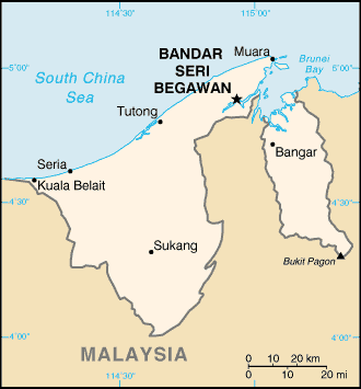
 Map of Brunei
Muara Town or Pekan Muara is located in Mukim Serasa[2] and is located on the easternmost tip of West Brunei. It lends its name to the district which it is in, the Brunei-Muara district. To the North is the South China Sea, to the south the Brunei Bay and across the bay, Pulau Muara Besar. To the east, across a man-made channel is the remains of Tanjung Pelumpong (Cape Pelumpong), now an island. To the west is the rest of the Brunei-Muara district. Serasa lies to the south-west of Muara.
For the purpose of this article, Muara includes the area from Kampong Sabun to the channel at Tanjung Pelumpong north of Serasa.
History
Before the 1900s, the village of Muara was inhabited by a small group of Malay fishermen.[3]
The development of the Serai Pimping area for coal extraction in 1883 for steamships, and later settlement of the area as Brooketon by Charles Brooke, the White Rajah of Sarawak in 1889 saw rapid development of the area. Brooketon was named after the White Rajahs of Sarawak gradually lent its name to the area which was then controlled by the government of Sarawak.
The development of the Brooketon Colliery coal mine also lead to transport and infrastructure development at Muara. A wooden railway was built to transport the coal to the safe deep-water anchorage at Muara, and wharves and jetties were built to allow steamships and barges to berth[3]. By 1911, more than 1,447 people lived in Muara and some 30 shops had opened in the town[3]. Brooketon was also where the first postage stamp in Brunei was used[4].
Politically too, even though he only had economic rights, Brooke became the de facto ruler of the area. The mine employed hundreds of miners and that required him to introduce a police force, post office and roads transforming Muara into an extraterritorial settlement an extension of Sarawak. It was not until 1921 that Muara was "returned" to Brunei[3]. The mine closed in 1924 because of heavy financial losses caused by continuously decreasing coal prices in the world economic recession[5].
The Japanese occupied Brunei during Second World War and attempted unsuccessfully to reopen the coal mine[3]. Brooketon was the landing location of the Australian forces as part of the Borneo Campaign (1945) at the end of the Second World War which liberated Brunei from Japanese occupation[6].
Under the rule of His Majesty the late Sultan Omar Ali Saifuddin, the area was developed into a deepwater port to assist in the development of the country. Since 1973, Muara Port has undergone extensive improvements. These include extensions to the wharf bringing the total length to 948 meters including 250 meters dedicated container wharf and 87 meters aggregate wharf. The overall storage space in the form of covered storage is 16,950 square meters, long storage warehouses 16,630 square meters and open storage space 5 hectares. Facilities for the dedicated container wharf covers an area of 92,034 square meters including 8,034 square meters covered areas[7].
Kampongs (Villages)
Pekan Muara can generally be further divided into the following areas:
- Town Centre
- Kampong Masjid Lama to the south of the Town Centre
- Kampong Sabun to the west and north-west, including the military barracks
- Kampong Tanjung Batu
- Kampong Pelumpong, and the area towards Tanjung Pelumpong
- Muara Beach
- Muara Port
These are the areas covered in this article. Other villages in Mukim Serasa (not covered in this article) include:
- Kampong Serasa is immediately adjacent to Pekan Muara to the south-west.
- Kampong Perpindahan Serasa to the south of Kampong Serasa
- Kampong Meragang is located between the Muara-Tutong Highway and Jalan Muara
- Kampong Kapok is located along Jalan Muara west of Kampong Serasa
- Kampong Pengalayan is located along Jalan Muara south-west of Kampong Kapok
- Kampong Salar is located along Jalan Muara south-west of Kampong Pengalayan
- Kampong Bukit Kabun
Oil and Gas
Part of the deepwater port of Muara is occupied by two Royal Dutch Shell petroleum facilities.
Brunei Shell Marketing has a large presence in Muara with its Muara Terminal[8]. There are numerous bottled gas containers on the site an a number of tanks holding various products including bitumen.
Brunei Shell Petroleum has a yard along Muara Port to support their offshore operations offshore in Brunei[9]. The jetty measures 120 metres by 48 metres and equipped with three loading facilities and 14 storage tanks.
Tourist attractions
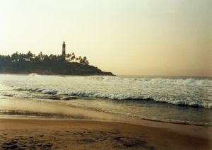
The main attraction of Pekan Muara is Muara beach (Pantai Muara in Malay) along South China Sea [10]. The beach is about a mile long and consists of clear white sand. Amenities here include a well-equipped picnic area, a children’s playground, changing and toilet facilities, as well as weekend food and drink stalls.
Military
The Royal Brunei Navy of the Royal Brunei Armed Forces is based in the Muara Naval Base which is located in Pekan Muara in the Tanjong Pelumpong area [11]. The Naval Base was expanded in 1997 to include facilities to support three offshore support vessels[12].
Transportation
Road
Jalan Muara is the main road that passes through Pekan Muara. It originates in Mukim Berakas near the Brunei International Airport and terminates at the artificial channel at Tanjong Pelumpong. It connects Muara town to Bandar Seri Begawan.
Jalan Serasa and Jalan Persuahan branches off from Jalan Muara and connects Muara with the neighbouring community of Serasa. It enables the items manufactured in the Serasa Industrial area to be transported to Muara Port for export.
The Muara-Tutong Highway starts at a roundabout on Jalan Muara between Kampong Sungai Kebun and Kampong Meragang. It connects Muara to Jerudong and Tutong.
Muara is served by the purple buses of the Eastern Line. Route numbers 33, 37, 38 and 39 connect Muara with Serasa and the rest of the country.
Rail
There are no railways or light rail in Muara. A railway line used to connect the Brooketon Colliery to what is now Muara Port to transport the coal being mined for use on the steamships[3].
Ports
The only deepwater port of Brunei is located in Muara. Muara Port was opened for commercial operations in February 1973, and commissioned as the Ports Department on 1st. May 1974. The Ports Department took over the whole management and operations of all the Ports on 1st.January 1986, form the Royal Customs and Excise Department[13].
The Muara Container Terminal was operated by the PSA International until 1 April 2007, when it reverted back to the Brunei Government. It had one container berth with a quay length of 250m and a max draft of 12.5m[14].
There is an existing plan to further develop the port by the Brunei Economic Development Board, including further dredging of the Muara Cut, the construction of additional port facilities on Pulau Muara Besar and linking the latter to the mainland with a bridge[15].
Air
There are no airports in Muara. Commercial travellers would have to travel to either Bandar Seri Begawan or Labuan (from Serasa) to catch a commercial flight.
Notes
- ^ Toponomy - the study of place names Brunei Resources 28-11-2006 - retrieved 19-04-2007
- ^ Poskod bagi Daerah Brunei Muara Brunei-Muara Postcodes - retrieved 19-04-2007
- ^ a b c d e f Before the Oil, it was Coal Brunei Times 14-04-2007
- ^ History of Brunei Stamps by the Brunei Postal Service Department - retrieved 19-04-2007
- ^ Brooketon Colliery from The Geology and Hydrocarbon Resources of Negara Brunei Darussalam retrieved 16-04-07
- ^ Negara Brunei Darussalam by A Allaert
- ^ 8th National Development Plan Government of Brunei Darussalam - retrieved 19-04-2007
- ^ BSM presents safety awards to Belait Shipping Company Brunei Government - retrieved 19-04-2007
- ^ New Muara Supply Base Jetty Boost for BSP’s Operations 13-03-2007 - retrieved 19-03-2007
- ^ Tourism Brunei Beaches - retrieved 19-04-2007
- ^ Introduction Royal Brunei Navy - retrieved 19-04-2007
- ^ page 15 GHD Annual Review 2002/2003
- ^ Ports Department - retrieved 19-04-2007
- ^ Muara Port Returns To Govt In April BruDirect 30-02-2007 - retrieved 19-04-2007
- ^ Pulau Muara Besar Port Project, BEDB - retrieved 28-05-2007
Categories:- Populated places in Brunei

Wikimedia Foundation. 2010.