- Cordillera Real (Bolivia)
-
For other uses, see Cordillera Real (disambiguation).
Cordillera Real Range 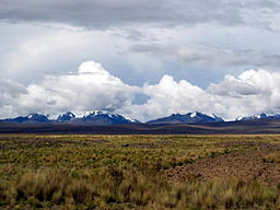 The peaks of the Cordillera Real as seen from the Bolivian Altiplano
Country Bolivia Region Altiplano Part of Andes Highest point Illimani - elevation 21,122 ft (6,438 m) - coordinates 16°39′14″S 67°47′05″W / 16.65389°S 67.78472°W Length 125 km (78 mi) Width 20 km (12 mi) Geology granite The Cordillera Real is a mountain range in the South American Altiplano of Bolivia. This range of fold mountains, largely composed of granite, is located southeast of Lake Titicaca, and east of the Bolivian capital of La Paz, measuring 125 km in length and 20 km in width.[1] Despite the fact that it is only 17° south of the Equator, the Cordillera Real is relatively densely glaciated. This is due to its proximity to the Amazon lowlands with its associated moist air masses.
Summits higher than 6,000 m
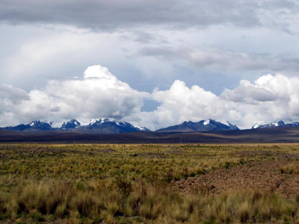
 Cordillera Real looking north, Illimani in foreground, Huayna Potosí upper left, Mururata to the right
There are six summits higher than 6,000 m in the mountain range which are, from north to south:
- Pico del Norte (6070 m)
- Illampú (6368 m)
- Ancohuma (6427 m)
- Chachacomani (6074 m)
- Huayna Potosi (6088 m)
- Illimani (6438 m)
Summits higher than 5,000 m
Other notable peaks include Mururata (5871 m), Chacaltaya (5421 m), and the Condoriri Massif. The Condoriri Massif is a complex of 13 peaks, all above the 5000 meter mark, including Cabeza de Condor (5540 m) and Pequeño Alpamayo (5370 m).[2] Other peaks of the Condoriri Massif include Pyramida Blanca (5250 m) and Tarija (5320 m).
References
- ^ "Travel map of the Andes". Nelles Map. http://andes.zoom-maps.com/. Retrieved 2010-12-10.
- ^ Newton P, Lillie M, Rosen N, Sameoe M, Davison J, ed (2010). Viva Travel Guides: Bolivia. Quito, Ecuador: Viva Publishing Network. pp. 170–171. ISBN 9780979126499. http://books.google.com/books?id=MgIYyFubx4cC&pg=PA170&lpg=PA170&dq=condoriri+meter+sorata&source=bl&ots=n1LC_j6ZgL&sig=V-P_Ii4yw1gVXfgP5ML8uC00dVI&hl=en&ei=WBGuTeawMufY0QGfz-mzCw&sa=X&oi=book_result&ct=result&resnum=3&ved=0CCIQ6AEwAg#v=onepage&q=condoriri%20meter%20sorata&f=false. Retrieved 2011-04-19.
Categories:- La Paz Department, Bolivia geography stubs
- Mountain ranges of Bolivia
- La Paz Department, Bolivia

Wikimedia Foundation. 2010.