- Coroico
-
Coroico 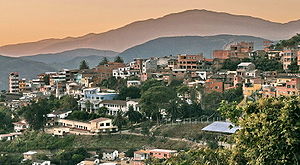 Location in Bolivia
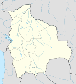
 Coroico
Coordinates: 16°11′S 67°44′W / 16.183°S 67.733°W Country  Bolivia
Department La Paz Department Province Nor Yungas Province Elevation 5,003 ft (1,525 m) Population (2001 census [1]) - Total 2,197 Coroico is a town in Nor Yungas Province, in the La Paz Department of western Bolivia.
History
Coroico Viejo (Old Coroico) was founded above the Kori Huayco River (which means "golden valley" in Aymara). The town lived from mining gold, but the massive attacks by Indians left the first settlers in search of protection.
Looking for a defendable position in the early 18th century, the settlers arrived at the current location of Coroico only to be chased into a cave by one of Mount Uchumachi's powerful lightning storms. The cave still exists below the church on the main plaza of Coroico. In the late 18th and early 19th centuries Coroico survived a couple of Indians attacks - the biggest one was at the time of the Bolivian War of Independence. 5000 Aymaras attacked the town, which in those days only had 500 inhabitants. The town stood strong, forcing the Aymaras into retreat.
Since then, Coroicans celebrate the Fiesta of the Virgin on October 20. Coroico became the capital of the North-Yungas in 1899 making Coroico the political and industrial center of the region, which produces wood products, fruits, and coca for the La Paz region of Bolivia. In 1958, the city was made the seat of the Territorial Prelature of Coroico, and elevated to the Roman Catholic Diocese of Coroico in 1983.
From the mid-18th century the lands in this region came under the control of a few powerful families, the hacienderos. These families maintained control of this region until the mid-1950s, when they were overthrown by revolution. After the revolution, agrarian reforms were put in place, dividing the lands up between the national government and the locals. Now, Coroico has a mostly Aymara and Mestizo population. The town has become a major market for the surrounding region. Staple products arrive from La Paz and the surrounding areas to be sold in the colorful markets and stores all days of the week. The region around Coroico has remained a traditional coca growing area and is the smallest of three areas of coca production in Bolivia.
Coroico emerald (esmeralda) green surroundings have become a welcoming sight for travelers tired of the harshness of the altiplano. The views of the surrounding hills are lovely, the nearby hiking trails are picturesque, the bars and restaurants in town are pleasant, and there are some worthwhile excursions. Here in this tropical town, you'll find fruit orchards, twittering birds, coca fields, endless greenery, oxygen-rich air, warm weather, and friendly locals. There are also some nice hikes in the area where you could spend a few days in Coroico exploring the area, such as hikes to waterfalls or to rivers.
New highway: On a part of the road from La Paz to Coroico a new highway has been opened at the end of 2006, and the old Yungas Road is now used mainly for bikers. This Yungas Road is also called the "death road".
The municipality of Coroico also hosts the Unidad Académica Campesina-Carmen Pampa (UAC-Carmen Pampa), a satellite campus of the Catholic University of Bolivia. Founded in 1993, the UAC-Carmen Pampa offers degree programs in agronomy, veterinary/animal science, nursing, education and tourism.[2]
References
- ^ "Instituto Nacional de Estadística". Instituto Nacional de Estadística de Bolivia. http://www.ine.gob.bo/comunitaria/comunitariaVer.aspx?Depto=02&Prov=14&Seccion=01. Retrieved 2011-10-07.
- ^ Carmen Pampa Fund. n.d. History and Mission of the College. Available at http://carmenpampafund.org/uac_history.htm. Accessed 2010-08-17.
External links
- Travel Guide to Coroico
- Coroico Travel Guide
- Weather in Coroico
- Coroico travel guide from Wikitravel
- The world's most dangerous road
- Biking the ROAD OF DEATH
Coordinates: 16°11′S 67°44′W / 16.183°S 67.733°W
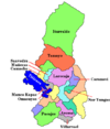
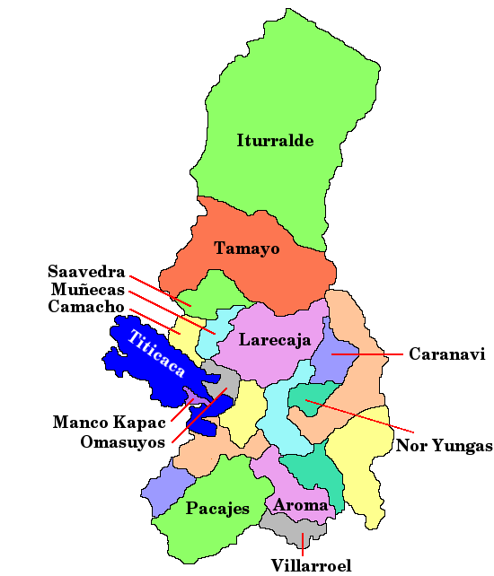
 La Paz Department
Capital: La Paz Provinces Abel Iturralde • Aroma • Bautista Saavedra • Caranavi • Camacho • Franz Tamayo • Gualberto Villarroel • Ingavi • Inquisivi • José Manuel Pando • Larecaja • Loayza • Los Andes • Manco Kapac • Murillo • Muñecas • Nor Yungas • Omasuyos • Pacajes • Sud Yungas
Municipalities
(and seats)Achacachi (Achacachi) • Achocalla (Achocalla) • Alto Beni (Caserío Nueve) • Ancoraimes (Ancoraimes) • Apolo (Apolo) • Aucapata (Aucapata) • Ayata (Ayata) • Ayo Ayo (Ayo Ayo) • Batallas (Batallas) • Cairoma (Cairoma) • Cajuata (Cajuata) • Calacoto (Calacoto) • Calamarca (Calamarca) • Caquiaviri (Caquiaviri) • Caranavi (Caranavi) • Catacora (Catacora) • Chacarilla (Chacarilla) • Charaña (Charaña) • Chulumani (Chulumani) • Chuma (Chuma) • Collana (Collana) • Colquencha (Colquencha) • Colquiri (Colquiri) • Comanche (Comanche) • Combaya (Combaya) • Copacabana (Copacabana) • Coripata (Coripata) • Coro Coro (Coro Coro) • Coroico (Coroico) • Curva (Curva) • Desaguadero (Desaguadero) • El Alto (El Alto) • Escoma (Escoma) • General Juan José Pérez (Charazani) • Guanay (Guanay) • Guaqui (Guaqui) • Huarina (Huarina) • Ichoca (Ichoca) • Inquisivi (Inquisivi) • Irupana (Irupana) • Ixiamas (Ixiamas) • Jesús de Machaca (Jesús de Machaca) • La Asunta (La Asunta) • La Paz (La Paz) • Laja (Laja) • Licoma Pampa (Licoma) • Luribay (Luribay) • Malla (Malla) • Mapiri (Mapiri) • Mecapaca (Mecapaca) • Mocomoco (Mocomoco) • Nazacara de Pacajes (Nazacara) • Palca (Palca) • Palos Blancos (Palos Blancos) • Papel Pampa (Papel Pampa) • Patacamaya (Patacamaya) • Pelechuco (Pelechuco) • Pucarani (Pucarani) • Puerto Acosta (Puerto Acosta) • Puerto Carabuco (Puerto Carabuco) • Puerto Pérez (Puerto Perez) • Quiabaya (Quiabaya) • Quime (Quime) • San Andrés de Machaca (San Andrés de Machaca) • San Buenaventura (San Buenaventura) • San Pedro de Curahuara (San Pedro de Curahuara de Carangas) • San Pedro de Tiquina (San Pedro de Tiquina) • Santiago de Callapa (Callapa) • Santiago de Huata (Santiago de Huata) • Santiago de Machaca (Santiago de Machaca) • Sapahaqui (Sapahaqui) • Sica Sica (Sica Sica) • Sorata (Sorata) • Tacacoma (Tacacoma) • Taraco (Taraco) • Teoponte (Teoponte) • Tiwanaku (Tiwanaku) • Tipuani (Tipuani) • Tito Yupanqui (Tito Yupanqui) • Umala (Umala) • Umanata (Umanata) • Viacha (Viacha) • Waldo Ballivián (Tumarapi) • Yaco (Yaco) • Yanacachi (Yanacachi)
Mountains Alpamayo Chico • Condoriri • Anallajsi • Ancohuma • Chachacomani • Chacaltaya • Illampu • Illimani • Huayna Potosí • MururataProtected areas Apolobamba • Cotapata • Madidi • Pilón Lajas
Categories:- Populated places in the La Paz Department, Bolivia


Wikimedia Foundation. 2010.