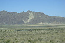
- Cronese Mountains
-
The Cronese Mountains are found in the Mojave Desert of San Bernardino County, California in the United States.
Geography
The small range is found north of Interstate 15, southwest of the town of Baker. The mountains are located at the northwestern edge of the Devils Playground and Mojave National Preserve.
Located at 35°06′50″N 116°18′50″W / 35.1138708°N 116.3139092°W,[1] they are southwest of the Soda Mountains. The eastern part of the range lies between East and West Cronese Dry Lakes, and the Arrowhead Trail (Arrowhead Highway) runs along the range near the freeway.
See also
References
- Allan, Stuart (2005). California Road and Recreation Atlas. Benchmark Maps. p. 96. ISBN 0-929591-80-1.
Coordinates: 35°06′50″N 116°18′50″W / 35.1138708°N 116.3139092°W
Categories:- Mountain ranges of Southern California
- Mountain ranges of the Mojave Desert
- Mountain ranges of San Bernardino County, California
- Mojave National Preserve
- San Bernardino County, California geography stubs
Wikimedia Foundation. 2010.

