- Naissaar
-
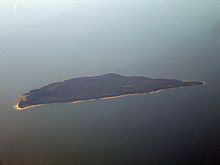
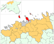
Naissaar (German: Nargen; Swedish: Nargö) is an island northwest of Tallinn (but belonging to Viimsi Parish) in Estonia. The island covers an area of 18.6 km². It is 13-14 km long and 6 km wide, and lies about 8.5 km from the mainland. The highest point on the island is Kunilamägi, which is 27 meters above sea-level. The island consists predominantly of coniferous forest and piles of stones and boulders. As of 2005, the island had a population of ten. Now the island has three dozen or so permanent residents and some summer residents.
Until the Second World War, the island's population numbered about 450 people of Estonian-Swedish origin. However, these people fled during the war. Naissaar under Soviet rule was a military area and off-limits to the public.
Although the fortifications on the island date back to Peter the Great's scheme to fortify Tallinn, the main fortifications are from the period of Russian rule before World War II. Today, the previous small houses of the Swedish villages are being restored bit-by-bit. Also being restored is a narrow gauge railway that runs from the north to the southern tip of the island.
A notable native of the island was Bernhard Schmidt, the Swedish-Estonian optician who invented the Schmidt telescope in 1930.
Contents
Lighthouse
The island received a lighthouse in 1788, though the present lighthouse dates to 1960. It is 47 meters tall.
History
The island's name means "island of women". It is possible, therefore, that Naissaar is the island the chronicle of Adam of Bremen mentioned around 1075 under the name "Terra Feminarum". Estonian Swedish fishermen were well-established on the island by the 15th Century, and the Swedes erected a small fortress there in 1705 during the Great Northern War. After the war Estonia became part of the Russian Empire. The Tsar had a new fortress, with five bastions, built in 1720, for the defense of Tallinn and St. Petersburg.
An epic single-ship action took place off the north end of the island on 23 June [O.S. 11 June] 1808 when the 14-gun Russian cutter Opyt put up an heroic though ultimately unsuccessful fight against the British 44-gun frigate HMS Salsette.
In 1850 the island's population was 155 people and by 1858 it had grown to 188, most of whom were Estonian Swedes. Between 1853 and 1856 the inhabitants built a new chapel that was part of the Swedish parish of St. Michael in Tallinn.
In the early twentieth century, Russia began the process of a modernization of its fortifications in the Gulf of Finland. However, the outbreak of the First World War stopped the planned improvements for Naissaar. Still, in 1914 the Russians opened a narrow-gauge railway line, with a total trackage of 37.7km.
World War I
The Russians built a new fort during the First World War. Estonia acquired some autonomy in April 1917 by a decree of the Russian provisional government, though Estonia remained under the suzerainty of the Russian Empire. However, after the October Revolutions the Bolshevik rebels suspended Estonia's provisional government, the Maapäev.
In December 1917, a group of Russian sailors commandeered Naissaar and proclaimed an independent "socialist republic", known as the Soviet Republic of Soldiers and Fortress-Builders of Nargen,[1] under the leadership of Stepan Petrichenko. The Russian sailors, numbering about 80-90 men, formed a government and levied taxes on the local population.[2]
At this point the new Estonian government appealed to the German army for assistance. The "republic" ceased to exist two days later, on February 26, 1918, when German forces occupied the island, causing the Russians to flee.[3] The sailors fled to Kronstadt, where Petrichenko came to play an important role in the Kronstadt uprising.
After the departure of the German troops the Estonian Provisional Government executed forty Bolshevik prisoners of war here in February 1919.[4] The island then became part of the new Estonian Republic in 1920.
Between the wars
The Estonian Republic too used Naissaar as a naval base. In 1934, 450 people lived on the island, of whom 291 were Estonians, most of whom in turn were in the Estonian army. The army of the Republic of Estonia continued to use the railway for military purposes throughout the 1930s.
World War II
The Red Army occupied Naissar in 1940, only to have the Wehrmacht displace it a few months later. The population of Swedish fishermen preferred the Germans, and when the Red Army drove the Germans out in 1944, the last of the Swedish-speaking fishermen took refuge in Sweden.
Post-war
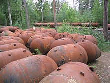
 Naval mines dating from the Soviet occupation
During the period of the Estonian Soviet Socialist Republic, the Soviet Union established its largest factory for naval mines in the Baltic on the island. The Soviets therefore declared the island a military area and off-limits to the public. The Soviets also used the railway to connect the factory to the port.
Post-Soviet period
When the Soviets left Naissaar in early 1993, they burned the explosives in the naval mines, leaving a multitude of metal casings scattered throughout the island. Many of these were scavenged as scrap iron, but a field of mines is still visible near the wharf at Mädasadam. Another legacy of the arms industry is that the soil of the island remains contaminated by oil and heavy metals.
In 1995 Naissaar was converted into a nature reserve.
On 10 August 2005 a helicopter belonging to the Finish airline Copterline crashed east of the island. The accident resulted in the death of all 14 persons on the helicopter.
See also
References
- ^ (Estonian) "Naissaare kroonika". http://web.archive.org/web/20050306142716/http://www.halo.ee/mart/tosilood/naissaar.html. Retrieved 2007-10-24.: "nõukogu kuulutab saare soldatite ja kindluseehitajate sotsialistlikuks vabariigiks."
- ^ (Estonian) "Jalutuskäik saladusliku Naissaare lõunarajal". Eesti Loodus. http://www.loodusajakiri.ee/eesti_loodus/artikkel977_958.html. Retrieved 2007-10-24.
- ^ (Estonian) "Naissaare kroonika". Archived from the original on 2005-03-06. http://web.archive.org/web/20050306142716/http://www.halo.ee/mart/tosilood/naissaar.html. Retrieved 2007-10-24.
- ^ Jackson, Battle of the Baltic, page 9
- This article incorporates information from the equivalent article on the French Wikipedia.
- This article incorporates information from the equivalent article on the German Wikipedia.
External links
- "Jalutuskäik saladusliku Naissaare lõunarajal"
- Fortress of Naissaar
- Fortress of Naissaar
- Photographs of Naissaar
- "Naissaar, Former Soviet Navy Base"
- Pictures and maps of Naissaar
- F.F. Raskolnikov, "Tales of Sub-Lieutenant Ilyin. A prisoner of the British"
Islands of Estonia Abruka · Adralaid · Aegna · Ahelaid · Aherahu · Ahessäär · Ahtra · Aksi · Allirahu · Allu · Alumine Vaika · Anekäbrud · Ankrurahu · Annilaid · Antsulaiud · Anulaid · Auklaid · Eerikukivi · Eerikulaid · Elmrahu · Esirahu · Gretagrund · Hanemaa · Hanerahu · Hanikatsi laid · Hara · Harilaid (islet) · Harilaid (peninsula) · Hellamaa rahu · Hiiumaa · Härjakare · Härjamaa · Hobulaid · Hõralaid · Hülgelaid · Hülgerahu · Imutilaid · Innarahu · Juksirahu · Kadakalaid · Kaevatsi · Kahtla · Kajakarahu · Käkimaa · Käkirahu · Kakralaid · Kakrarahu · Karirahu · Kassari · Kasselaid · Keri · Keskmine Vaika · Kesselaid · Kihnu · Kitselaid · Koerakuiv · Kõinastu laid · Koipsi · Kõrgelaid · Kõrksaar · Kõverlaid · Kreenholm · Kriimi laid · Kräsuli · Kuivarahu · Külalaid · Kullilaid · Kullipank · Kumari · Kungli · Kunnatilaid · Kuradisäär · Kurgurahu · Külalaid · Küllisäär · Laasirahu · Laidu · Läkumätas · Langekare · Leemetikare · Liia · Liisi · Liivakari · Linnusitamaa · Loonalaid · Luigerahu · Maakrirahu · Manilaid · Mardirahu · Maturahu · Mihklirahu · Mohni · Mondelaid · Muhu · Munaderahu · Munasaar · Mustarahu · Mustpank · Mustpank (Vaika) · Nabralaid · Naissaar · Naistekivi maa · Ninalaid · Noogimaa · Nootamaa · Nosurahu · Öakse · Oitma · Ojurahu · Öörahu · Orikalaid · Osmussaar · Paelaid · Pakri Islands · Pakulaid · Papilaid · Papirahu · Pasilaid · Pedassaar · Pihanasu · Pihlakare · Pihlalaid · Piirissaar · Pikknasv · Piskumadal · Prangli · Puhtulaid · Puningalaid · Põdvalaid · Põiksäär · Pühadekare · Rammu · Rannasitik · Riinurahu · Ristlaid · Rohurahu · Rohusi saar · Rooglaid · Ruhnu · Rukkirahu · Rusulaid · Saare ots · Saaremaa · Saarnaki laid · Salava · Sangelaid · Seasaar · Selglaid · Sepasitik · Sillalaid · Sipelgarahu · Sitakare · Sokulaid · Sorgu · Suuregi laid · Suurepoldi · Suurlaid · Suur-Pakri · Suurrahu · Sõmeri · Taguküla laid · Tarja · Tauksi · Telve · Tiirloo · Tondirahu · Tondisaar · Täkulaid · Täkunasv · Udrikulaid · Uhtju saar · Uhtju saared · Ulkkarri · Umalakotid · Ülemine Vaika · Umblu · Urverahu · Uuluti laid · Uus-Nootamaa · Vahase · Vahelmisrahu · Vaika saared · Väike-Pakri · Väike-Tulpe · Vaindloo · Valgerahu · Vareslaid (Käina) · Vareslaid (Väinameri) · Varesrahu · Vasikalaid · Vesiloo · Vesitükimaa · Viirelaid · Vilsandi · Vissulaid · Vohilaid · Vormsi · Võilaid · Võiste · Võnnu · Võrgukare ·
Settlements in Viimsi Parish Small boroughs Haabneeme • Viimsi
Villages Äigrumäe • Idaotsa • Kelnase • Kelvingi • Lääneotsa • Laiaküla • Leppneeme • Lubja • Metsakasti • Miiduranna • Muuga • Naissaare • Pärnamäe • Pringi • Püünsi • Randvere • Rohuneeme • Tammneeme
Coordinates: 59°34′N 24°31′E / 59.567°N 24.517°ECategories:- Viimsi Parish
- Islands of Estonia
- States and territories established in 1917
- Harju County geography stubs
Wikimedia Foundation. 2010.


