- Fort Bend Parkway Toll Road
Infobox TX State Highway
type=State
route=122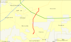
name=Fort Bend Parkway Toll Road
shields=
length_mi=7.5
formed=1988TxDOT|SH|122]
dir1=North
dir2=South
from=
junction= in Houston
to=
previous_type=State
previous_route=121
next_type=State
next_route=123The Fort Bend Parkway Toll Road connects State Highway 6 near Sugar Land in eastern Fort Bend County to US 90A in southwestern Harris County. It is proposed to reach a northern terminus at the southwestern edge of Interstate 610 in the near future. The toll road has two lanes in each direction with major interchanges at State Highway 6, Lake Olympia Parkway, and FM 2234. A main toll plaza is located north of FM 2234 with ramp tollbooths at FM 2234 and Lake Olympia Parkway. The cost for the toll road is estimated between $55 million and $60 million. The
Harris County Toll Road Authority (HCTRA) administered the northern segment of the road—just south ofBeltway 8 at the county line to US 90A—and uses its purple pentagonal shield referred to as the Fort Bend Toll Road. Like other toll roads in theGreater Houston , the speed limit is 65 mph—even inside Beltway 8.History
The tollway's origins date back to TxDOT's (Texas Department of Transportation) original proposal of building a highway from the southwest corner of Loop 610 in Houston (where North Braeswood and 610 meet). A section of frontage roads (later part of Hillcroft Avenue in Houston) were constructed in the late 1960s/early 1970s (date unknown) south of the proposed Beltway 8 (
Sam Houston Tollway ) south of Harris County adjacent to the Chasewood and Willow Park II subdivisions in northeast Fort Bend County.Originally planned as either the West Loop Extension or the Bay City Freeway, the proposed freeway was cancelled in 1979 although remnants of the freeway exist (an extension of South Post Oak between West Bellfort and North/South Braeswood, along with a section of the Fort Bend Tollway between Beltway 8 and West Fuqua in Fort Bend County). Although the 1979 cancellation has ended TxDOT's highway proposal, Fort Bend County had an interest in the roadway project since 1984. On
March 29 ,1988 , the parkway was officially designated by TxDOT as State Highway 122—stretching from Beltway 8 to the Grand Parkway (SH 99). Environmental and feasibility studies were conducted during the next 10 years.In November 2000, citizens of Fort Bend County approved a $140 million bond issue to support revenue bond financing for construction of the Parkway and Westpark projects. After fulfilling prudent feasibility studies and careful planning, Fort Bend County Toll Road Authority (FBCTRA) broke ground and began the construction phase in July 2003. The Fort Bend Parkway Toll Road opened
August 30 ,2004 .Harris County Commissioners' Court approved an approximate five-mile extension of the proposed Fort Bend Parkway Toll Road project. While the primary corridor was constructed by the Fort Bend County Toll Road Authority, the extension was built by the Harris County Toll Road Authority and provides a connection from the Fort Bend County line at Beltway 8 to US Highway 90A, and to the existing Post Oak Road at West Bellfort—near the southwest corner of the 610 Loop.
In 2006, the State Highway 122 designation was removed from the section north of State Highway 6.
In July 2008, cash collection was discontinued on the Fort Bend Parkway Toll Road (maintained by FBCTRA). The only valid payments on this portion of the toll road is either HCTRA's
EZ TAG , NTTA'sTollTag , orTxTAG . Cash collection (in the form of exact change) continues on the HCTRA maintained segment, the Fort Bend Toll Road. [ [http://www.fbctra.com/fbctra_011.htm Parkway EZ-Tag Conversion] ]ignage and Designation
The name of the road and its signage change along its route:
* Fort Bend Toll Road - from US 90 Alt to Beltway 8 / Sam Houston Parkway
* Fort Bend Parkway Toll Road - from Beltway 8 / Sam Houston Parkway to SH 6
* jct|state=TX|SH|122 (proposed) - from SH 6 to SH 99 (Grand Parkway)It should be noted that although eventually the Fort Bend Toll Road (Harris County), Fort Bend Parkway Toll Road (Fort Bend County), and the proposed State Highway 122 will all connect as one contiguous route, each are signed as separate routes. State Highway 122 does not actually exist except on paper right now, remaining as the placeholder for TXDOT in case they were to decide to use state funding to bulid the final portion.
Exit list
The proposed SH 122 would extend from SH 6 to the planned segment of SH 99 that will be built to the south.The Future Fort Bend Parkway Tollway will expand pass SH 6.The expanded route will be in a trench at the over pass at Sh 6.and also in the future S Post Oak Road/Chimney Rock road will be a part of the fort bend parkway tollway.
References
* [http://www.fbctra.com/ Fort Bend County Toll Road Authority]
* [http://www.hctra.com/ Harris County Toll Road Authority]
Wikimedia Foundation. 2010.
Fort Bend County Toll Road Authority — The Fort Bend County Toll Road Authority (FBCTRA), located in Sugar Land, Texas, is currently managing the successful development and completion of two key county mobility projects, the Fort Bend Parkway Toll Road and the Fort Bend Westpark… … Wikipedia
List of toll roads in the United States — This is a list of toll roads in the United States. This list does not include toll bridges or tolled tunnels or tolled ferries. Alabama*Foley Beach Express *Black Warrior ParkwayAlaska*Knik Arm CrossingArkansas*Interstate 540/Bella Vista Bypass… … Wikipedia
List of Houston highways — This is a list of highways in the Houston–Sugar Land–Baytown metropolitan area.FreewaysPresentUnder construction*jct|state=TX|SH|99 Parts of Section I 2 of the Grand Parkway are under construction.Future*Fairmont/Red Bluff Freeway planned from… … Wikipedia
South Bend, Indiana — Infobox Settlement official name = City of South Bend, Indiana nicknames = settlement type = City imagesize = 250px image caption = South Bend from above image mapsize = 250x200px map caption = Location in the state of Indiana mapsize1 = map… … Wikipedia
Indiana State Road 2 — Infobox road state=IN type=IN route=2 alternate name= maint=INDOT length mi=80.98 length round=2 length ref= [http://illi indi.com/EndsPage.php?id=1002 section=1 Indiana Highway Ends SR 2] ] established= direction a=West starting terminus= near… … Wikipedia
Texas State Highway NASA Road 1 — State Highway NASA Road 1 Route information … Wikipedia
Westpark Tollway — Infobox TX State Highway shields= name=Westpark Tollway type= route= length mi=20 length ref= length round=1 formed=2004 dir1=West dir2=East from= junction= to=Westpark Drive previous type= previous route= next type= next route=The Westpark… … Wikipedia
Interstate 10 in Texas — This article is about the section of Interstate 10 in Texas. For the entire length of the highway, see Interstate 10. Interstate 10 … Wikipedia
Interstate 45 — Route information Maintained by … Wikipedia
U.S. Route 290 — U.S. Highway 290 Route information Maintai … Wikipedia
Fort Bend Parkway Toll Road

18+
© Academic, 2000-2025
- Contact us: Technical Support, Advertising
Dictionaries export, created on PHP, Joomla, Drupal, WordPress, MODx.