Mount Sonder

Mount Sonder
Mount Sonder

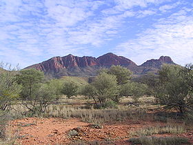
Mount Sonder from the east
Elevation 1,380 m (4,528 ft) AHD
Location
Location Northern Territory, Australia
Range MacDonnell Ranges
Coordinates 23°35′S 132°36′E / 23.583°S 132.6°E / -23.583; 132.6Coordinates: 23°35′S 132°36′E / 23.583°S 132.6°E / -23.583; 132.6
Climbing
Easiest route Hike

Mount Sonder, or Rwetyepme, its Aboriginal name, is the fourth highest mountain in the Northern Territory, Australia at 1380 metres above sea level. Mount Zeil is the highest at 1531 metres, 27 kilometres to the west. It is 130 km (81 mi) west of Alice Springs along the MacDonnell Ranges in the West MacDonnell National Park. It marks one end of the celebrated Larapinta trail, which extends 223 kilometres to Alice Springs. The shape of the mountain is a double peak, the relative heights of which are somewhat ambiguous from the summit, although easy to identify from the surrounding plains. The mountain can be seen for the western half of the Larapinta trail, up to Ormiston Pound, which obscures it from then on.

A clearly defined walking track exists up the western side, taking about 12 kilometres. Water is available from a water tank 50 m beyond the carpark, and a direction plate can be found at the summit. This however is not the true summit, which is 750m away, but has been chosen for safety reasons. The view from the top boasts the taller Mount Zeil to the west, the West MacDonnell Range to the east, Glen Helen , a nearby resort, to the east and Gosses Bluff to the south west on a clear day.

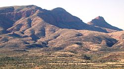
Close-up of Mount Sonder from the south


References


Wikimedia Foundation. 2010.

Игры ⚽ Нужно решить контрольную?

Look at other dictionaries:

  • Mount Giles — See also Mount Giles (Antarctica) Mount Giles Mount Giles from the opposite side of Ormiston Pound in the south Elevation …   Wikipedia

  • Larapinta Trail — Infobox Hiking trail Name= Larapinta Trail Photo=Larapinta Trail.jpg Caption=Along the Larapinta trail from a ridge of the West MacDonnell Ranges. Location=Northern Territory, Australia Length=Convert|223|km|mi|0 Start/End Points= Alice Springs,… …   Wikipedia

  • Macdonnell Ranges — Blick über die West MacDonnell Ranges vom Larapinta Trail in der Nähe von Glen Helen Luftaufnah …   Deutsch Wikipedia

  • MacDonnell Ranges — The MacDonnell Ranges of the Northern Territory, are a 644 km (400 mile) long series of mountain ranges located in the centre of Australia (coord|23|42|S|132|30|E|region:AU NT), and consist of parallel ridges running to the east and west of Alice …   Wikipedia

  • List of mountains in Australia — This list is incomplete; you can help by expanding it. See also: List of mountains: Australia. This is a list of mountains in Australia. These are some of the highest mountains in Australia Contents 1 Highest point in each State/Territory …   Wikipedia

  • MacDonnell Ranges — p1 MacDonnell Ranges Blick über die West MacDonnell Ranges vom Larapinta Trail in der Nähe von Glen Helen Höchster Gipfel …   Deutsch Wikipedia

  • Ormiston Pound — The western half of Ormiston Pound with Mount Giles in the foreground Ormiston Pound is a ring of mountains punctuating the MacDonnell Ranges, in the West MacDonnell National Park, approximately 135 kilometres west of Alice Springs[1] in the… …   Wikipedia

  • Northern Territory — For similar terms, see Northern Territories (disambiguation). Coordinates: 20°0′S 133°0′E / 20°S 133°E / 20; 133 …   Wikipedia

  • West MacDonnell National Park — Infobox protected area of Australia | name = West MacDonnell National Park iucn category = II caption = locator x = 143 locator y = 95 nearest town or city = Alice Springs coordinates = coord|23|26|11|S|132|25|05|E|type:landmark region:AU area =… …   Wikipedia

  • West-Macdonnell-Nationalpark — Rungutjirpa (Simpson s Gap) Der West MacDonnell Nationalpark (engl. West MacDonnell National Park) umfasst ein 2.069 km² großes Gebiet im Gebirgszug der MacDonnell Ranges im australischen Nordterritorium westlich der Stadt Alice Springs. Er wurde …   Deutsch Wikipedia

Share the article and excerpts

Direct link
Do a right-click on the link above
and select “Copy Link”