Mporokoso

Mporokoso
Location of Mporokoso in Zambia

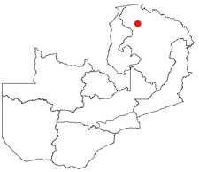
Mporokoso (also spelled and pronounced 'Mpolokoso' and 'Mumpolokoso') is a town in the Northern Province of Zambia, lying at an elevation of nearly 1500 m on the flat plateau about 75 km south east of Lake Mweru Wantipa and 100 km south-west of Lake Tanganyika. It is named for Chief Mporokoso (also spelled 'Mumpolokoso') a senior chief of the Bemba people whose palace is located in the town.[1] Mporokoso District is also one of the 12 administrative districts of the Northern Province.

A large population of refugees from the Second Congo War living at the UNHCR-administered refugee camp at Mwange, 32 km west of the town, are being repatriated after the end of that war.

A number of waterfalls lie within 50 km of the town. The closest is the Kapuma Falls, 7km south-west of the town centre. Pule Falls and Mumbuluma Falls III are on the Luangwa River (not to be confused with the river of that name in eastern Zambia) which flows to the south of the town. Lupupa Falls are on the nearby Mukubwe River.

References

  1. ^ Times of Zambia accessed 4 February 2007

Coordinates: 9°23′S 30°06′E / 9.383°S 30.1°E / -9.383; 30.1


Wikimedia Foundation. 2010.

Игры ⚽ Нужна курсовая?

Look at other dictionaries:

  • Mporokoso — Geographische Lage von Mporokoso in Sambia Mporokoso, auch Mumpolokoso, ist ein kleiner Ort mit 3.491 Einwohnern (Schätzung 2006) in der Nordprovinz von Sambia. Mporokoso liegt 1.150 Kilometer nördlich von Lusaka und 169 Kilometer westlich von… …   Deutsch Wikipedia

  • Mporokoso — Original name in latin Mporokoso Name in other language Mpolokoso, Mporokoso State code ZM Continent/City Africa/Lusaka longitude 9.37272 latitude 30.12501 altitude 1442 Population 3401 Date 2012 01 17 …   Cities with a population over 1000 database

  • Mporokoso District —   District   District location in Zambia Country …   Wikipedia

  • Mporokoso Group — The Mporokoso Group is the name given to a sedimentary succession of fluvial, lacustrine and aeolian sandstones and minor siltstones occurring on the Bangweulu Block of northern Zambia. The succession is likely to be largely over 1.8 billion… …   Wikipedia

  • Mporokoso District — Admin ASC 2 Code Orig. name Mporokoso District Country and Admin Code ZM.05.175966 ZM …   World countries Adminstrative division ASC I-II

  • District de Mporokoso — Districts de Zambie Vue sur une carte de District de Mporokoso Administration Pays …   Wikipédia en Français

  • Chief Mporokoso — (also spelled Mpolokoso and Mumpolokoso ) is a senior chieftainship of the Bemba people of Zambia, and a subordinate chief of Paramount Chief Chitimukulu. The chief s palace is located in the Northern Province town of Mporokoso named after the… …   Wikipedia

  • Mumpolokoso — Geographische Lage von Mporokoso in Sambia Mporokoso, auch Mumpolokoso, ist ein kleiner Ort mit 3.491 Einwohnern (Schätzung 2006) in der Nordprovinz von Sambia. Mporokoso liegt 1.150 Kilometer nördlich von Lusaka und 169 Kilometer westlich von… …   Deutsch Wikipedia

  • Northern Province, Zambia — Northern Province is one of Zambia s nine provinces. It covers approximately one fifth of Zambia in land area. The provincial capital is Kasama. The province is made up of 12 districts, namely Kasama (the provincial capital), Chilubi, Isoka,… …   Wikipedia

  • Luapula Province border dispute — This article deals mainly with a disputed area on the border of Zambia, in Luapula Province.Where it all began 1894 treatyZambia s formal northern frontier boundary was legally signed in the Anglo Belgian Treaty of 1894, long after the 1884… …   Wikipedia

Share the article and excerpts

Direct link
Do a right-click on the link above
and select “Copy Link”