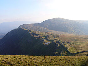
Diffwys

Diffwys
Diffwys

Diffwys and Crib-y-rhiw from Y Llethr
Elevation 750 m (2,461 ft)
Prominence 148 m (486 ft)
Listing sub Marilyn, Hewitt, Nuttall
Location
Location Gwynedd, Wales
Range Rhinogydd
Topo map OS Landranger 124
OS grid SH661234
Listed summits of Diffwys
Name Grid ref Height Status
Diffwys West Top 642 metres (2,106 ft) sub Hewitt, Nuttall

Diffwys is a mountain in Snowdonia, North Wales, near Barmouth and forms part of the Rhinogydd. On the north side is an exposure of the Caerdion Syncline. It is technically a subsidiary summit of Y Llethr, missing Marilyn status by 2m. It is therefore like Rhinog Fach a sub Marilyn.

The summit has a trig point. To the north is Y Llethr and Crib-y-rhiw, to the east is Y Garn, to the south is Cadair Idris, and to the west is its top Diffwys West Top.[1]

References

  1. ^ Nuttall, John & Anne (1999). The Mountains of England & Wales - Volume 1: Wales (2nd edition ed.). Milnthorpe, Cumbria: Cicerone. ISBN 1-85284-304-7.

External links

Coordinates: 52°47′29″N 3°59′14″W / 52.79151°N 3.98716°W / 52.79151; -3.98716


Wikimedia Foundation. 2010.

Игры ⚽ Нужно решить контрольную?

Look at other dictionaries:

  • Diffwys West Top — Diffwys (left) and Diffwys West Top (right) with Llyn and Craig Bodlyn Elevation …   Wikipedia

  • Rhinogydd — The Rhinogydd (a Welsh plural form, often anglicised as Rhinogs and also known by the alternative Welsh plural Rhinogau) are a range of mountains located east of Harlech in North Wales.The Rhinogydd are notably rocky and heather clad towards the… …   Wikipedia

  • Slate industry in Wales — The slate industry in Wales began during the Roman period when slate was used to roof the fort at Segontium, now Caernarfon. The slate industry grew slowly until the early 18th century, then expanded rapidly until the late 19th century, at which… …   Wikipedia

  • Dwyfor Meirionnydd (UK Parliament constituency) — Not to be confused with Dwyfor Meirionnydd (National Assembly for Wales constituency). Coordinates: 52°50′56″N 3°58′59″W / 52.849°N 3.983°W …   Wikipedia

  • List of Sites of Special Scientific Interest in Clwyd — This is a list of the Sites of Special Scientific Interest (SSSIs) in the Clwyd Area of Search. For SSSIs elsewhere in Wales, see List of SSSIs by Area of Search.* Afon Dyfrdwy (River Dee) * Alyn Valley Woods and Alyn Gorge Caves * Berwyn * Blaen …   Wikipedia

  • Llechwedd quarry — is a major slate quarry in the town of Blaenau Ffestiniog, north Wales. At its peak in 1884 it produced 23,788 tons of finished slate per year and had 513 employees. It continues to produce slate on a limited scale and is the location of the… …   Wikipedia

  • Blaen y Cwm Quarry — The Blaen y Cwm Quarry was a slate quarry located east of Blaenau Ffestiniog in Wales. It was first worked in some time between 1813 and 1818 and sporadically after that until 1914. The quarry was connected to the Ffestiniog Railway at Duffws… …   Wikipedia

  • Schieferindustrie in Wales — Die Schieferindustrie in Wales geht auf die Zeit der Besetzung Britanniens durch das Römische Reich zurück. Dachschindeln aus Schiefer wurden bereits beim Bau eines römischen Lagers in der Nähe des heutigen Caernarfon verwendet. Bis zum Beginn… …   Deutsch Wikipedia

  • Crib-y-rhiw — The Crib y rhiw ridge with Y Garn (left) Elevation 670 m (2,198 ft) …   Wikipedia

Share the article and excerpts

Direct link
Do a right-click on the link above
and select “Copy Link”