- Low, Quebec
Infobox Settlement
official_name = Low
nickname = Paugan
motto =
imagesize = 220px
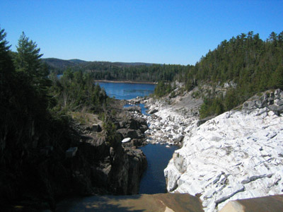
image_caption = View down Paugan Dam
flag_size = 120x100px
image_shield =
shield_size = 120x100px
mapsize =
subdivision_type = Country
subdivision_name =Canada
subdivision_type1 = Province
subdivision_name1 =Quebec
subdivision_type2 = Region
subdivision_name2 = Outaouais
established_title =
established_date =
established_title2 = Incorporation
established_date2 = January 1, 1858
government_type = Township
leader_title = Mayor
leader_name =Michael Francis
area_total_km2 =
area_land_km2 = 260.68
area_water_km2 =
area_footnotes = [Statistics Canada
[http://www.mamr.gouv.qc.ca/cgi-bin/repert1.pl?region=&mrc=&geo=83010&muni= Ministère des Affaires Municipales et Régions] shows an area of 259.95 km2.]
population_as_of= 2006
population_footnotes = [Statistics Canada 2006 Census]
population_total = 956
population_density_km2 = 3.7
timezone = EST
utc_offset = -5
timezone_DST = EDT
utc_offset_DST = -4
postal_code_type = Postal Code
postal_code = J0X
latd = 45 | latm = 48 | lats = | latNS = N
longd = 75 | longm = 57 | longs = | longEW = W
elevation_footnotes=
elevation_m =
website = [http://www.lowquebec.ca/ www.lowquebec.ca]
footnotes =Low is a township municipality in the La Vallée-de-la-Gatineau Regional County Municipality of western
Quebec , Canada. It is situated along theGatineau River north of Wakefield, and it is located within Canada's National Capital Region. Its 2001 population was 852.Low received its name from
Charles Adamson Low , a lumber merchant who held timber rights in the Gatineau Valley.A section of Low called Tucker Lake was home of the Gatineau Clog, a country music festival founded by
Wayne Rostad in 1980.The mayor of Low is currently Michael Francis who has been mayor since 1997.
Geography
Low is situated in a corner of mountainous terrain on the edge of the
Gatineau Hills , but conducive to agriculture. It is dotted with an abundance of lakes, most notably Sainte-Marie, Island, Doyle, cameron, and Venosta Lakes.cite web |url=http://www.toponymie.gouv.qc.ca/ct/topos/carto.asp?Speci=37339&Latitude=45,83333&Longitude=-76,01666&Zoom=1700 |title=Canton de Low |accessdate=2008-07-21 |publisher=Commission de toponymie du Québec |language=French]History
Low represents a rare case where the township was formed after the municipality; the township dates back to 1859 whereas the municipality was founded in 1848 and the municipality township was officially established on 1 January 1857, and which came into force on 1 January 1858. It was named after Charles Adamson Low, an important timber merchant of the region in the mid 19th century, a time when many Irish immigrants settled here. Its post office was established in 1854.cite web |url=http://www.toponymie.gouv.qc.ca/ct/topos/carto.asp?Speci=37349&Latitude=45,81667&Longitude=-75,95&Zoom=1700 |title=Municipalité de Canton de Low |accessdate=2008-07-21 |publisher=Commission de toponymie du Québec |language=French]
Demographics
Population: [Statistics Canada: 1996, 2001, 2006 census]
* Population in 2006: 956
* Population in 2001: 852
** 2001 to 2006 population change: 12.2 %
* Population in 1996: 807
* Population in 1991: 892Total private dwellings (excluding seasonal cottages): 419
Languages:
* English as first language: 48.7 %
* French as first language: 49.7 %
* Other as first language: 1.6 %Paugan Hydroelectric Station
The Paugan Station ("Centrale de Paugan"), built in 1928, is a run-of-river hydroelectric power station and dam on the Gatineau river, operated by
Hydro-Québec . It has a head of m to ft|40.5|precision=1, and 8 turbines with a total capacity of 202 MW. Its reservoir is km2 to mi2|30|precision=0. [cite web |url=http://www.hydroquebec.com/production/hydroelectrique/gatineau/paugan/index.html |title=Centrale de Paugan |publisher=Hydro-Québec |accessdate=2008-07-21]References
Geographic Location
Centre = Low
North = Kazabazua
Northeast = Lac-Sainte-Marie
East = Denholm
Southeast =
South = La Pêche
Southwest =
West = Alleyn-et-Cawood
Northwest =
Wikimedia Foundation. 2010.