- Washington State Route 7
Infobox WA State Route|type=State|route=7|sec=030
length_mi=58.25
length_ref=
length_round=2
formed=1964
dir1=South
dir2=North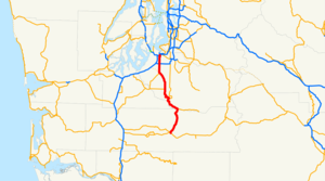
from=
junction=
to=
next_type=State|previous_type=State|next_route=8|previous_route=6State Route 7 is a numbered
state highway in thestate ofWashington ,U.S.A. It extends about 55 miles from Morton in the southwest to Interstate 5 at Tacoma.Route description
State Route 7 originates as a two-lane highway at U.S. Route 12 in the town of Morton and proceeds north, crossing the
Nisqually River into Pierce County at the town of Elbe. From here, State Route 706 provides access to theLongmire entrance ofMount Rainier National Park , a popular recreation and tourism destination. From here to Spanaway, SR 7 is known as the "Mountain Highway," as it is the best route from the Puget Sound population centers to the south side ofMount Rainier .SR 7 becomes a busy four lane highway about 3 miles before its intersection with SR 507, at an intersection known as the Roy "Y". At the Roy "Y", SR 7 enters Spanaway and becomes Pacific Avenue. Ten miles later, after entering the city of Tacoma, SR 7 turns east onto 38th Street. After crossing A Street, it exits 38th Street onto a 0.75 mile long limited access freeway. SR 7 terminates at Interstate 5 exit 133, with the roadway continuing north as Interstate 705.
Major intersections
References
External links
* [http://www.angelfire.com/wa2/hwysofwastate/sr007.html Highways of Washington State]
* [http://www.highwaygeek.com/WA7.htm HighwayGeek Washington 7]

Wikimedia Foundation. 2010.