- Mount Jukes (Tasmania)
-
Mount Jukes Elevation 1,104 m (3,622 ft) Location Location West Coast, Tasmania Range West Coast Range Coordinates 42°10′S 145°34′E / 42.167°S 145.567°ECoordinates: 42°10′S 145°34′E / 42.167°S 145.567°E Mount Jukes is a mountain in the West Coast Range on the West Coast of Tasmania, Australia. It was named by Charles Gould in 1862 after Professor Joseph Beete Jukes, English geologist, who was involved in issues relating to Charles Darwin. Jukes had visited Hobart in 1842-3 on HMS Fly.
With multiple peaks, and glacial lakes on its upper eastern reaches, Mount Jukes was the mountain above the town of Crotty and is west of what is now Lake Burbury.
Contents
Mines
It has had mines and small mining camps adjacent to the lakes, and on the northern upper slopes, near where the Mount Jukes road traverses the upper slopes of the King River Gorge.
Road
Mount Jukes Road (22 km length) [1] was constructed by the Hydro in the 1980s at the time the Crotty Dam was made. It connects southern Queenstown with Darwin Dam, where the previously utilised North Mount Lyell Railway formation between the Linda Valley and Crotty was submerged by Lake Burbury.
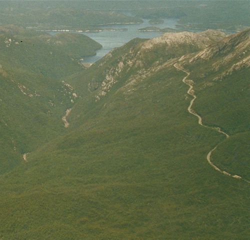 Aerial photograph of lower slopes of Mount Huxley (to the left), King River gorge in the left lower, Crotty Dam and Lake Burbury (to the rear), northern slopes (that is Proprietary Peak) of Mount Jukes on the right, Mount Jukes Road in right foreground, and to the right rear the different coloured upper part of East Jukes Peak
Peaks and spurs
Mount Jukes has a number of named features[2]:-
- Jukes Range - is the name to the ridge between Proprietary Peak in the north, and South Jukes Peak
- East Jukes Peak - 731 metres - closest to King River Gorge and the Crotty Dam, and to the north of the Mount Jukes road.
- Proprietary Peak - 1104 metres - north west of main part of Mount Jukes, with the Crown spur the most noticeable feature when viewed from the town of Quuenstown to the north.
- Mount Jukes - 1168 metres
- Central Peak
- West Jukes Peak - 1062 matres
- Pyramid Peak - 1080 metres
- South Jukes Peak - 1014 metres
Other named features that are not given specific heights include:-
- Yellow knob
- Yellow Knob spur
- South Jukes Spur
- Crown Spur
- East Jukes Spur
- Intercolonial Spur
- Cliff Spur
- Newall Spur
Lakes
Two named glacial lakes in the upper part of the eastern side of the mountain are:-
- Upper Lake Jukes
- Lower Lake Jukes
It is by the lakes that a number of small mines were started in the early years of the twentieth century.
West Coast Range- Mount Huxley
- Mount Jukes
- Mount Darwin
Notes
References
- Blainey, Geoffrey (2000). The Peaks of Lyell (6th ed. ed.). Hobart: St. David's Park Publishing. ISBN 0-7246-2265-9.
- Crawford, Patsy (2000). King: Story of a River. Montpelier Press. ISBN 1-876597-02-X.
- Whitham, Charles (2003). Western Tasmania - A land of riches and beauty (Reprint 2003 ed.). Queenstown: Municipality of Queenstown.
- 2003 edition - Queenstown: Municipality of Queenstown.
- 1949 edition - Hobart: Davies Brothers. OCLC 48825404; ASIN B000FMPZ80
- 1924 edition - Queenstown: Mount Lyell Tourist Association. OCLC 35070001; ASIN B0008BM4XC
Map Reference
- Tasmania 1: 25 000 series maps
- Owen 3833 (Edition 2 2001) - for northern part
- Darwin 3832 - for southern part
Categories:- Mountains of Tasmania
- Western Tasmania
- West Coast Range (Tasmania)

Wikimedia Foundation. 2010.