2004 Utica earthquake

2004 Utica earthquake

earthquake
title= 2004 Utica earthquake
date= June 28, 2004
magnitude = 4.2 Mw
countries affected = flag|United States
casualties = none
depth = convert|5|km|mi|1
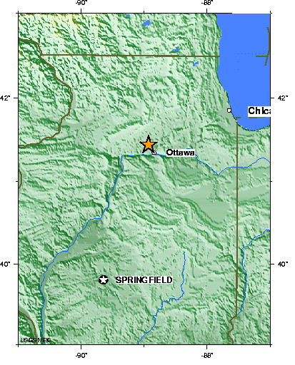
location = coord|41|44|N|88|92|W|scale:5000000_region:US-IL|display=inline,title

The 2004 Utica Earthquake was a 4.2 magnitude earthquake that occurred on June 28, 2004 at about 1:11 am which affected northern Illinois and was mostly felt in Utica, Illinois and surrounding rural towns. Its epicenter was located two miles south of Prairie Center, Illinois and could be felt as far away as Olive Branch, Mississippi.cite web |url=http://earthquake.usgs.gov/eqcenter/eqinthenews/2004/uskgad/ |title=Earthquake summary |date=2004-06-28 |accessdate=2008-01-02 |author=United States Geological Service]

The earthquake was the first in LaSalle County, Illinois since September 1972. It occurred convert|5|km|mi|1 beneath the surface in a structure associated with the Sandwich Fault Zone. It was not connected with the New Madrid Fault farther south, which has been linked to the Midwest's most serious earthquakes. No injuries were reported, yet thousands of people were startled and awoken in the middle of the night. Three nearby nuclear power plants—LaSalle, Quad Cities, and Dresden—issued low-level alerts, but no damage was found.

References

External links

* [http://earthquake.usgs.gov/eqcenter/eqarchives/poster/2004/20040628.php USGS Earthquake Poster] - Poster of the affected area, including historical data and Generalized Seismic Hazard


Wikimedia Foundation. 2010.

Игры ⚽ Нужен реферат?

Look at other dictionaries:

  • North Utica, Illinois — Utica, Illinois redirects here. For other uses, see Utica (disambiguation). Coordinates: 41°20′32″N 89°0′51″W / 41.34222°N 89.01417°W / …   Wikipedia

  • List of earthquakes in the United States — The following is a list of earthquakes in the United States. * 1700 Cascadia earthquake* 1812 New Madrid earthquake* 1857 Fort Tejon earthquake* 1872 Lone Pine earthquake* 1886 Charleston Earthquake* 1906 San Francisco earthquake* 1933 Long Beach …   Wikipedia

  • LaSalle County, Illinois — Infobox U.S. County county = LaSalle County state = Illinois map size = 150 founded = 1829 seat = Ottawa | area total sq mi =1148 area land sq mi =1135 area water sq mi =13 area percentage = 1.14% census yr = 2000 pop = 111509 density km2 =81 web …   Wikipedia

  • Lisbon — For other uses, see Lisbon (disambiguation). Coordinates: 38°42′49.72″N 9°8′21.79″W / 38.7138111°N 9.1393861°W / 38.713811 …   Wikipedia

  • Huntington Beach High School — Infobox School name =Huntington Beach High School native name = latin name = imagesize = caption = location = streetaddress =1905 Main Street region = city =Huntington Beach state =California province = county =Orange County postcode = postalcode …   Wikipedia

  • List of Nike missile locations — Nike Missile family, From left, MIM 3 Nike Ajax, MIM 14 Nike Hercules, LIM 49 Nike Zeus. Map of all coordinates from Google …   Wikipedia

  • Faro, Portugal — This article is about the Portuguese city. For other uses, see Faro. Faro (Portuguese pronunciation: [ˈfaɾu]) is the southernmost city in Portugal. It is located in the Faro Municipality in southern Portugal.[1] The city proper has 41,934[2] …   Wikipedia

  • Spain — /spayn/, n. a kingdom in SW Europe. Including the Balearic and Canary islands, 39,244,195; 194,988 sq. mi. (505,019 sq. km). Cap.: Madrid. Spanish, España. * * * Spain Introduction Spain Background: Spain s powerful world empire of the 16th and… …   Universalium

  • Oswego County, New York — Seal …   Wikipedia

  • NY1 — For other uses, see NY1 (disambiguation). NY1 Launched September 8, 1992 Owned by Time Warner Cable Picture format SDTV 4:3 AR; 480i HDTV 16:9 AR; …   Wikipedia

Share the article and excerpts

Direct link
Do a right-click on the link above
and select “Copy Link”