- The Strand (bicycle path)
[
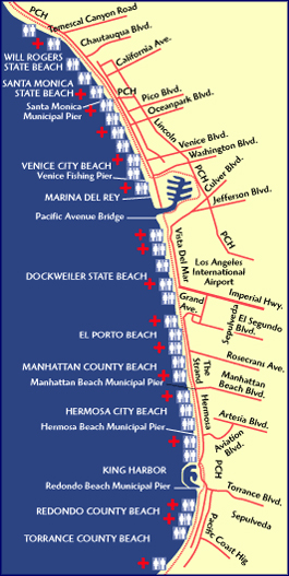 frame|South Bay Bike Trail [http://www.coastalconservancy.ca.gov/Wheel/ source] ] The South Bay bicycle path is a mixed-type bicycle route in
 Los Angeles County . The trail starts as a separate, paved Class 1 bicycle path going Southbound atWill Rogers State Beach (aboutTemescal Canyon and the Pacific Coast Highway) and ends in Torrance County Beach. The path is 22 miles long, and the midpoint between the two ends of the path is near the southern end of the Playa del Rey residential area. The South Bay bicycle path is a paved path that provides access to the beach and other unimproved property.Southbound from
Will Rogers State Beach , the path passes through Santa Monica, under theSanta Monica Pier , then continues alongSanta Monica State Beach to Venice, where it veers off from and parallelsOcean Front Walk until Washington Boulevard /Venice Pier , where the separate Class 1 path ends temporarily.The trail continues by turning left into a bike lane, which goes east for about 1/4 to 1/2 mile just past Palawan Way, at which point the Class 1 path resumes.
The paved path passes the wildlife refuge, then parallels
Admiralty Way until it crosses it at a traffic signal, then passes theMarina Library , which is open six days a week and has public restrooms.Past the library, the path continues to parallel Admiralty Way, then turns slightly Westward and ends at Fiji Way, where it once again becomes a bike lane.
Along Fiji Way near the lighthouse on the north side of the street there is a bike rental shop that leaves an air hose with electric compressor outside the shop for all to use. Take your Presta adaptor along. There is a bicycle mechanic available in the rental shop Thursday through Sunday. Also near the lighthouse are the best public restrooms along the path.
Following the lane on Fiji Way around the end, just after the Coast Guard station and condominiums, the Class 1 bike path resumes with a choice of two directions: Going east is the Ballona Creek extension; going west resumes travel on the main Strand path.
The Ballona Creek Path goes east for six miles into Culver City ending near Syd Kronenthal Park, which has shaded picnic tables and bathrooms. CAUTION: There have been reports of Culver City street gang members attacking bicyclists on the Ballona Creek path.
The Strand continues west from the junction past the UCLA boathouse and traverses the top of a levee that separates the main Marina Channel from the Ballona Creek. The strongest headwind (southbound) or tailwind (northbound) of the path will be experienced on the levee during normal weather conditions.
The levee portion of the path ends at the Pacific Avenue bridge over Ballona creek after which the path turns onto another paved (concrete) path and continues past
Dockweiler Beach State Park , where the view includesairplanes andhang glider s.The South continuation passes two power stations on the left (with characteristic smoke stacks), and continues through Manhattan Beach State Park to Manhattan Beach Pier, which has public restrooms. Turning inland at this point leads to a handful of restaurants.
Continuing South from here another 1/2 mile or so, the path will split, but both directions lead to the Hermosa Beach path:
* The straight branch is a bike lane that runs parallel to Hermosa Avenue, followed by astop sign and a walkway withspeed bump s, and ends at the Hermosa Beach path at 24th Street.
* Turning right leads to a short stairway, at the bottom of which is the start of the Hermosa Beach path.Another mile or so South is the
Hermosa Beach Pier . There are plenty ofrestaurants on the pier to the left, and bathrooms to the right. There is a small bike shop just North of the pier, one block East of the path on 13th Street. They keep a charged air hose outside their shop with Presta adapors in the small wooden box.Note, the flashing lights on the path indicate bikers are expected to dismount and walk their bikes; cyclists who don't heed the signals could be ticketed.
After continuing South for about another mile, the path turns left at a concrete wall (where there is often pedestrian traffic, so caution is warranted), and leads to the intersection of Herondo/190th and Harbor/Hermosa Avenue.
Turning right, Southbound, there are wide bike lanes on either side of Harbor Avenue that go about a mile, to Beryl Street. To the left there is a power plant (a very large building with sea life paintings on the wall facing the path). Further down are the King Harbor restaurants and the Sports center on the right.
About 1/2 mile past Beryl Street the path veers to the right off Harbor Avenue and resumes being a two-way Class 1 path, which leads South toward the parking structure for the Redondo King Harbor Pier. Following the path that curves to the right and thenh left will bring riders South through the parking garage, and eventually to the Southern part of the pier, where there are tourist shops, places to eat, and a police station. There is a Bank of America ATM outside the parking structure on the southern wall, next to the bike path entrance. Cyclists are advised to heed the flashing lights indicating they should dismount and walk for half a block.
On the other side of the pier the path continues South for another 2 or 3 miles along the
pacific ocean . It dead-ends into a parking lot at the base of thePalos Verdes hills. Adventurous off-road cyclists can climb a medium-steep grade ramp from the parking lot into thePalos Verdes hills, where cycling is substantially more difficult. Note, however that posted signs prohibit cycling on the ramp.__NOTOC__
Entry points / parking
Many of the state beaches along the bike route have
parking meters . The prices are normally around 25 cents every 20 minutes and 10 cents for ten minutes of parking. Parking enforcement officials are usually in the area giving fines to people with expired meters.There is unrestricted parking except for street sweeping days in the residential areas along Torrance Beach.
Next to the Pacific Street Bridge in Playa del Rey there is a small "pay & display" parking lot bordering the bike path.
There is free parking at the Syd Kronenthal Park at the east end of the Ballona Creek extension of the bike path. However, it is a 6-mile ride westward to the main path from here.
In the northern section of Hermosa Beach there are meters along the street parallel to the Strand that do not start operating until 10am.
California Street in Santa Monica has a bicycle lane that extends from Seventeenth Street to Ocean Avenue. To access the path from this lane, continue west from the intersection of Ocean Avenue down the California Incline. Halfway down the Incline take the entrance to the pedestrian bridge that crosses Pacific Coast Highway. The beach-side access the bridge is a spiral ramp, which is situated in the parking lot of a beachside café and bicycle rental. A concrete path goes from here to the path. Taking this route, one can descend the bluffs, cross PCH and get to the bicycle path without dismounting.
At the northern end of the path there is a bicycle lane along Temescal Canyon Road that goes 1.1 miles east to Sunset Boulevard in Pacific Palisades.
Bicycling hazards particular to the Strand
In numerous places the path tends to acquire a layer of beach sand, which makes the smooth cement surface very slippery to bicycle tires. Sand is a particular problem where the path meanders through the beach, creating a hazardous situation with sand on the curves.
There are a few locations where the path turns abruptly at 90 degree angles, sometimes onto the street, and some have walls where one would collide if the turn is made incorrectly.
References
The LA bike paths [http://www.labikepaths.com/] web site covers the Strand in two sections: South Bay [http://www.labikepaths.com/SoBay.html] and Venice/Santa Monica [http://www.labikepaths.com/SantaMon.html] .
A photographic description of the whole route is available on-line [http://www.lkjh.biz/bike/california/la/south_bay/index.html] .
ee also
Los Angeles bike paths
Wikimedia Foundation. 2010.