- Mons Penck
-
Mons Penck 
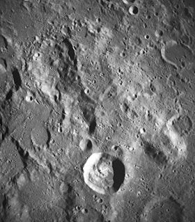
Mons Penck lies near the right edge of this image, just below center. Also visible are the craters Kant (lower center) and Zöllner (upper left). NASA photo.Elevation 4 km Listing Lunar mountains Translation Albrecht Penck (Latin) Location Location the Moon Coordinates 10°00′S 21°36′E / 10.0°S 21.6°E Mons Penck is a mountain promontory on the near side of the Moon. It lies just to the northeast of the crater Kant, to the north of Ibn-Rushd and the Rupes Altai scarp. Southeast of Mons Penck are the prominent craters Theophilus and Cyrillus.
The selenographic coordinates of this peak are 10.0° S, 21.6° E. It has a diameter of about 30 km at the base and climbs to an altitude of 4 km (13,000 feet). It was named after Albrecht Penck (1858–1945), a German geographer and geologist.
External links
- LTO-78C1 Kant — L&PI topographic orthophotomap map.
Categories:- LQ20 quadrangle
- Mountains on the Moon
- Moon stubs
Wikimedia Foundation. 2010.
