- Cape Woolamai, Victoria
Infobox Australian Place
type = suburb
name = Cape Woolamai
state = vic
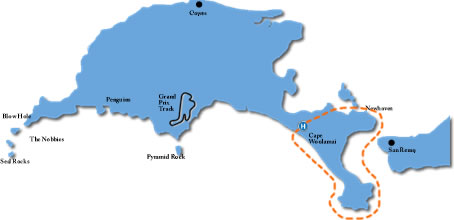
caption = A map of Phillip Island with Cape Woolamai shown
lga = Bass Coast Shire
postcode = 3925
pop = 1234 (2006)Census 2006 AUS | id = SSC25305 | name = Cape Woolamai (State Suburb) | accessdate = 2007-10-01 | quick = on]
area =
est = 1959
propval = $250,500 [ [http://www.domain.com.au/public/suburbprofile.aspx?suburb=Cape%20Woolamai&postcode=3925%20Cape%20Woolamai Suburb Profile at Domain.com.au] , accessed 14 January 2007]
stategov = Bass
fedgov = Flinders
dist1 = 140
location1=Melbourne
dist2 =
location2=
near-nw =Surf Beach
near-n = Newhaven
near-ne = Newhaven
near-w =Bass Strait
near-e =Western Port
near-sw =Bass Strait
near-s =Bass Strait
near-se =Western Port Cape Woolamai is a small town and headland at the south eastern tip of Phillip Island in Victoria,
Australia . It is home to Cape Woolamai State Faunal Reserve, and the Phillip Island Airfield. Cape Woolamai contains a subdivision also called Cape Woolamai (formerly known as Woolamai Waters and Woolamai Waters West).History
The cape was named by
George Bass (but spelt "Wollamai") when he passed it on his whaleboat voyage in early 1798. [gutenberg|no=12929|name=A Voyage to Terra Australis by Matthew Flinders, volume 1, his entry for3 May 1802 ] "Wollamai" is the snapper fish ("Pagrus auratus ") in the language of theEora aboriginal people ofPort Jackson , where the fish is found. ["Australian Aboriginal words in English",R. M. W. Dixon ,Oxford University Press , 1990, ISBN 0-19-553099-3] Bass, who had learnt some of the Sydney language from the Eora leaderBennelong , [Miriam Estensen, "The Life of George Bass", Allen and Unwin, 2005, ISBN 1-74114-130-3] ) thought the headland resembled the head of that fish.The area was purchased from the government in 1868 by John Cleeland, sea captain, publican and owner of the
Melbourne Cup winner of 1875, 'Wollomai'. He then built Wollomai House, and ranmerino sheep fromNew South Wales . In 1910 his son, John Blake Cleeland, noticed the sand was shifting due to erosion so he planted rows ofMarram grass , still evident today.In 1959, convert|230|acre|km2 of farmland was sold and subdivided into housing estates for beach shacks and holiday makers. It was then named ' Woolamai Waters and Woolamai Waters West ', and later renamed ' Cape Woolamai '. Cape Woolamai had a Post Office from 1970 to (probably) 1974 which was open only during summer. Citation
last = Premier Postal History | title = Post Office List | url = https://www.premierpostal.com/cgi-bin/wsProd.sh/Viewpocdwrapper.p?SortBy=VIC&country= | accessdate = 2008-04-11 ] The roads were sealed in the late 1980s and beach shacks gradually turned into more substantial houses. Today Cape Woolamai has a world-renowned surf beach, Woolamai Beach Surf Life Saving Club, and a popular Safety Beach. It still contains remnant vegetation and wildlife such as an important breeding colony of theShort-tailed Shearwater or AustralianMuttonbird . Volunteer groups such as the Cape Woolamai Coast Action Group conduct regular improvement and maintenance works including weed control and revegetation.Gallery
References
External links
* [http://www.basscoast.vic.gov.au/ Bass Coast Shire Website]
* [http://www.basscoast.vic.gov.au/files/623_Cape%20Woolamai.pdf Downloadable map of Cape Woolamai]
* [http://www.penguins.org.au/content.asp?pg=78 Official Profile at Phillip Island Nature Parks]
* [http://www.domain.com.au/real-estate/Cape+Woolamai/16.html Profile at Domain.com]
* [http://www.visitphillipisland.com/searchDetail.asp?ID=5 Profile at VisitPhillipIsland.com](coord|38|34|S|145|21|E|display=title
Wikimedia Foundation. 2010.