- California State Route 26
Infobox road
state=CA
type=SR
route=26
section=326
maint=Caltrans 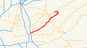
length_mi=62
length_round=0
length_ref= [ [http://www.dot.ca.gov/hq/structur/strmaint/brlog2.htm January 1, 2006 California Log of Bridges on State Highways] ]
direction_a=West
terminus_a=jct|state=CA|SR|99 near Stockton
junction=jct|state=CA|SR|12 at Valley Springs
jct|state=CA|SR|49 at Mokelumne Hill
direction_b=East
terminus_b=jct|state=CA|SR|88 near Pioneer
previous_type=SR
previous_route=25
next_type=SR
next_route=27State Route 26 is a
state highway in theU.S. state ofCalifornia , running from Stockton to State Route 88 near Pioneer. This route is part of theCalifornia Freeway and Expressway System [http://www.leginfo.ca.gov/cgi-bin/displaycode?section=shc&group=00001-01000&file=250-257 CA Codes (shc:250-257)] ] .Route description
The western terminus is at State Route 99 in Stockton. The eastern terminus is at State Route 88 near Pioneer. Prior to 1994, Route 26 extended past Route 99 to State Route 4.
The segment between the community of Mokelumne Hill and West Point is named the Stephen P. Teale Highway. [cite book | url=http://www.dot.ca.gov/hq/tsip/hseb/products/2006_Named_Freeways.pdf | title=2006 Named Freeways, Highways, Structures and Other Appurtenances in California | publisher=
Caltrans | pages=77 | accessdate=2007-03-28] Bridge 30-0052, crossing the Middle Fork of theMokelumne River , near West Point, is named the Tom Taylor Bridge. [Ib. at 103 ]Major intersections
:"Note: Except where prefixed with a letter,
postmile s were measured in 1964, based on the alignment as it existed at that time, and do not necessarily reflect current mileage. The numbers reset at county lines; the start and end postmiles in each county are given in the county column."References
External links
* [http://www.dot.ca.gov/hq/roadinfo/sr26 Caltrans: Route 26 highway conditions]
* [http://www.cahighways.org/025-032.html#026 California Highways: Route 26]

Wikimedia Foundation. 2010.