- Kilteely-Dromkeen
-
Kilteely - Dromkeen
Cill Tíle - Drom Caoin— Town — Location in Ireland
 Kilteely - Dromkeen
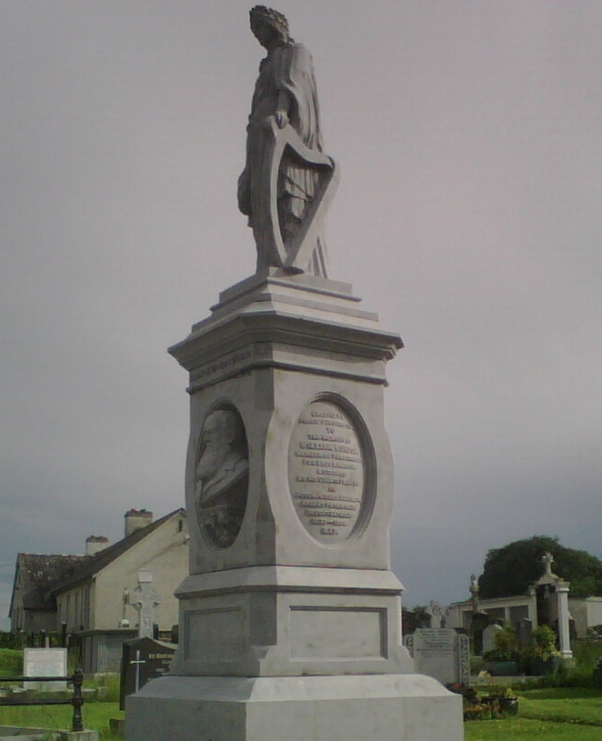
Coordinates: 52°33′14″N 8°23′29″W / 52.55402°N 8.391495°WCoordinates: 52°33′14″N 8°23′29″W / 52.55402°N 8.391495°W Country Ireland Province Munster County County Limerick Government – Dáil Éireann Limerick East Time zone WET (UTC+0) – Summer (DST) IST (WEST) (UTC-1) Area code(s) 061-38**** Irish Grid Reference R726413IrishGrid  Monument commemorating William Lundon, which stands in the grounds of the graveyard at Kilteely village, which is situated in county Limerick, Ireland.
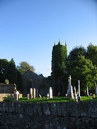 The Old Church of Ireland Church at Dromkeen, near the site of the Dromkeen Ambush.
Kilteely and Dromkeen is a parish in the Roman Catholic Archdiocese of Cashel and Emly. It is located in east County Limerick in the province of Munster, Ireland, near the border of County Tipperary. The village of Kilteely or in Irish Cill Tíle (The Church of Tidel) stands below the Hill of Kilteely, about 14 miles south-east of Limerick City.
The village of Dromkeen or in Irish Drom Caoin (The Smooth Ridge) is little more than a crossroads on the N24 Limerick- Waterford Road, halfway between Limerick City and Tipperary Town.
Contents
Geography
The landscape in this parish is subtly unusual, different from the predominantly flat County Limerick This is due to the fact that Kilteely-Dromkeen is situated in one of the most important Carboniferous Volcanic districts in either Great Britain or Ireland. A wide variety of igneous rocks from two volcanic phases of about 300 million years ago can be found here. The volcanic plugs of Knockderk 220 m (782 ft) and Kilteely Hill 176 m (580 ft) are both conical in appearance, while in the neighbouring parish of Pallasgreen stands the Hill of Nicker, where hardened lavas have formed a cliff of basalt hexagons, similar to those found at the Giant's Causeway. As the area is within the Golden Vale, the land in this area is generally good, and is used primarily for the grazing of livestock and some tillage. The Mulkear river flows through the eastern edges of Dromkeen parish.
History
Dromkeen is famous for the Dromkeen Ambush, an attack on Black and Tan police forces during the Irish War of Independence in 1921. The attach was carried out near the old Church of Ireland church in a joint operation between the East Limerick and West Limerick Brigades of the IRA. A Flying Column force of about 40 ambushed two lorrys carrying between them 13 Black and Tan police officers. Two of the these managed to escape, however the other 11 were killed. It was one of the larger operations carried out by the IRA during the War of Independence, the IRA had been expecting a larger police force.
In modern times, Dromkeen was well-known for its ballroom of romance, "The Oyster Ballroom",[1] owned by the Hayes family which in the 1950s and 60s attracted large crowds, sometimes up to 2,000 dancers from counties Limerick and Tipperary for the weekly Sunday night dance where the leading showbands of the day played on a regular basis.
Education
The parish is served by two primary schools; Kilteely National School is located in Kilteely village, Cloverfield National School is located in Dromkeen parish.
Sport
There is a strong [[Gaelic Athletic Association|G.A.A.] following in the area. Teams from Kilteely-Dromkeen GAA Club compete in the East Limerick Division at Junior and under-age competitions in Hurling and Gaelic football. Kilteely AFC Soccer club was founded in 1983 and plays its football in the Limerick city and county leagues.
People
- Willie O'Dea (born November 27, 1952) - Fianna Fáil T.D. for Limerick East and Minister for Defence.
- John Francis Dillon (born July 24, 1930 - died August 18, 1952) - Killed in the Korean War.
- William Lundon (born 1839 - died March 24, 1909) - Irish Parliamentary Party M.P. for East Limerick.
Transport
- Dromkeen railway station opened on 2 February 1851, closed for goods traffic on 9 September 1963, and finally closed altogether on 6 September 1976.[2]
See also
References
- ^ "Oyster Ballroom Dromkeen". www.irish-showbands.com. http://www.irish-showbands.com/ballroom_photoslo.htm. Retrieved 2007-11-28.
- ^ "Dromkeen station". Railscot - Irish Railways. http://www.railscot.co.uk/Ireland/Irish_railways.pdf. Retrieved 2007-10-12.
Categories:- Parishes in Archdiocese of Cashel and Emly


Wikimedia Foundation. 2010.