- Barberêche
Infobox Swiss town
subject_name = Barberêche
municipality_name = Barberêche
municipality_type = municipality
imagepath_coa = Barbereche-coat of arms.svg|pixel_coa=
languages = French
canton = Fribourg
iso-code-region = CH-FR
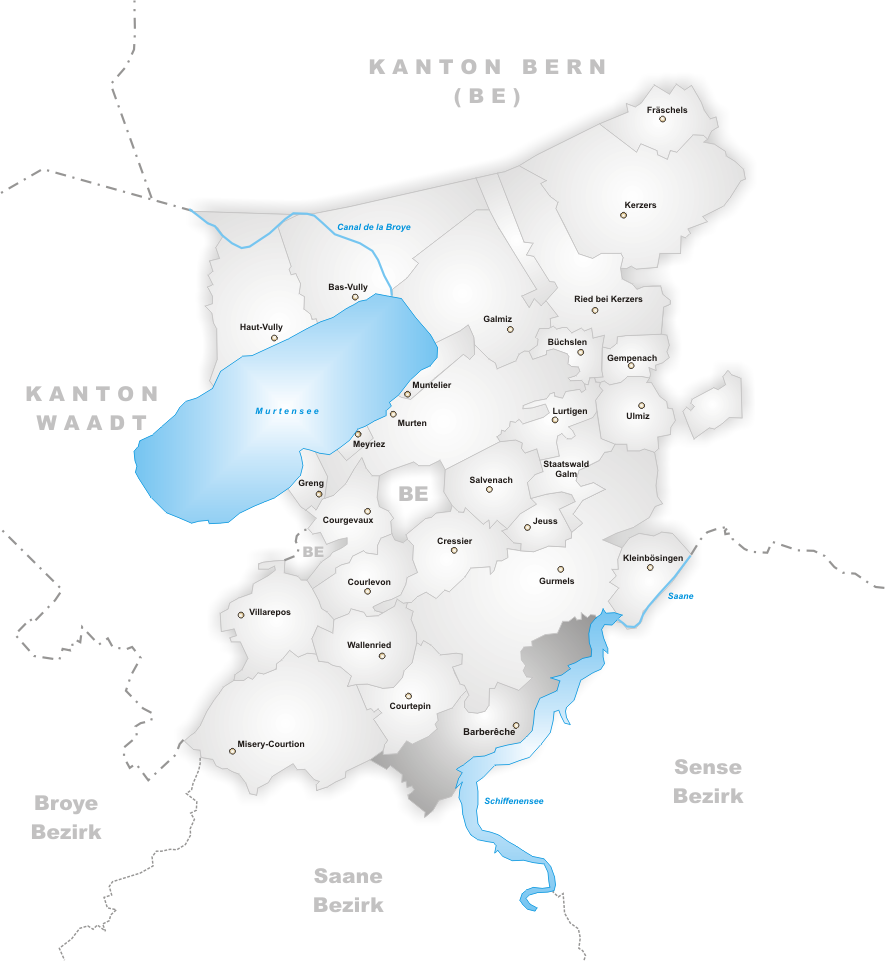
district = See/Lac
lat_d=46|lat_m=51|lat_NS=N|long_d=7|long_m=10|long_EW=E
postal_code = 1783
municipality_code = 2243
area = 9.13
elevation = 569|elevation_description=
population = 574|populationof=2003
website = www.barbereche.ch
mayor = |mayor_asof=|mayor_party=
mayor_title = |list_of_mayors =
places =
demonym =
neighboring_municipalities=La Sonnaz ,Misery-Courtion ,Courtepin ,Gurmels ,Düdingen
twintowns = |Barberêche is a municipality in the district of Lac in the Swiss canton of Fribourg. It lies on the "language boundary" between the French- and German-speaking parts of
Switzerland , and so also bears a German name: Bärfischen. In 2003 its population was 574.Geography
Barberêche lies 569 m above
sea level , and is 5.5 km north of the cantonal capital,Fribourg (Freiburg). The surrounding rural municipality stretches along the north shore of theSchiffenensee , a small lake through which flows the riverSaane/Sarine , at the foot of the "Grand Bois" ("Great Wood") hill on theSwiss plateau . Barberêche's coördinates are coord|46|51|N|7|10|E|region:CH.The municipality's area is 9.1 km², and includes a part of the Swiss plateau's molasse uplands. The sprawling, yet narrow, area is bordered on the southeast by the Schiffenensee. All along this reservoir's shoreline in the Barberêche area is a 20- to 50-m-high dike topped with trees, broken here and there by
sandstone cliffs . Several gullies carved byerosion empty into thelake ; these have been partially flooded owing to the creation of the reservoir. The gullies divide the terrace that Barberêche is built on into several smallplateau x, which themselves are abutted in the northwest by the molasse hill.In the farthest south and southwest, the municipality area reaches beyond the
Courtepin Valley to the flats at the mouth of the stream La Sonnaz where it empties into the Schiffenensee. From here westwards, the district stretches to the Bois de la Corbaz (a wood), which reaches 650 m above sea level, and to the edge of the Bois de l'Hôpital ("Hospital Wood") (660 m above sea level). Towards the northeast, the municipality stretches over the Breilles Heights — which at 668 m above sea level are Barberêche's highest point — the Bouley Forest, and the Grand Bois, as well as the Bulliardholz (another wood; 660 m), and on to the foot of the "Great Wood" ("Grossholz") atKleingurmels .Land use
In 1997, uses for the municipality's land broke down thus:
*Habitation: 5%
*Forest and Wood: 21%
*Agriculture: 60%
*Unproductive (lakeside flats): 14%Population centres
Barberêche consists of several centres, namely:
*thevillage itself, Barberêche, 569 m above sea level.
*the village "Pensier" (Ger.: Penzers), 584 m above sea level, up from the mouth of the Sonnaz on the Schiffenensee.
*the hamlet "Hobelet" (Ger.: Hubel), 655 m above sea level, on the heights above Pensier.
*the hamlet "Villaret", 610 m above sea level, above the Courtepin Valley.
*the hamlet "Breilles" (Ger.: Brigels), 640 m above sea level, on the edge of the Bouley.
*the hamlet "Petit Vivy" (Ger.: Klein-Vivers), 590 m above sea level, on the terrace above the Schiffenensee east of the Grand Bois.
*the hamlet "Grand Vivy" (Ger.: Gross-Vivers), 565 m above sea level, on the terrace above the Schiffenensee east of the Bulliardholz.
*the hamlet "Grimoine" (Ger.: Courmoen), 565 m above sea level, on the terrace above the Schiffenensee south of Kleingurmels.Neighbouring municipalities to Barberêche are
La Sonnaz ,Misery-Courtion ,Courtepin ,Gurmels andDüdingen .Population
With only 574 inhabitants, Barberêche is among the smaller communities in the canton of Fribourg. The most heavily populated place in the municipality is Pensier with about 250 people; only about 100 people live in the village of Barberêche itself. Historically, Barberêche's population has varied from 389 in 1850 to 507 in 1900, reaching its highest ever point in 1960, when there were 674 residents. By 1980, though, the population had declined by over 25% to 499 as people left Barberêche. Since then, the population figure has rebounded somewhat.
Languages
French-speaking residents of Barberêche number 74.2% while German-speaking people account for 21.8%. Also, 1.3 % of Barberêche's population are Portuguese-speaking (as of 2000). Until the 15th century, the local language was almost exclusively German. The French-speaking community slowly grew until in the 18th and 19th centuries, the village was bilingual. French has been the majority language in Barberêche since about 1860.
Economy
Barberêche was until the second half of the 20th century a village whose livelihood was firmly rooted in
agriculture . Even today, tilling the soil, growing fruit, and raising cattle are important to the local economy. Other jobs are to be found insmall business and theservice sector . There is a commercial area in Pensier. Until 1976, there was aboarding school at Barberêche (Institut Saint-Dominique). Over the last few decades, the village has developed itself into a bedroom community. Many of the residents nowadays arecommuter s who work in Fribourg.Transportation
The municipality is well connected, even though it lies far from the main
highway s. The nearestexpressway interchange, A12 (Berne -Vevey ) lies about 5 km from the centre of the municipality. On23 August 1898 , therailway line from Fribourg toMurten opened, with a station in Pensier. The village of Barberêche itself has no public transport connections.History
The Barberêche area was settled quite early on, as witnessed by archaeological finds of graves from Hallstatt times and foundations from Roman times.
The first documentary mention of Barberêche dates from 1154 under the name "Barbereschi". Later names included "Barberesche" (1173), "Barbaresche" (1180), "Barbareschi" (1182) and "Barbarica" (1423). The placename goes back to an old family name "Barbar(i)us".
There is evidence to show that, as of the 12th century, there was a noble family in Barberêche. The Barberêche
Lord ship fell in the beginning under theDuke s ofZähringen , and then later became afiefdom of theCounts of Thierstein , before a series of changes in ownership in the 15th century. In 1442, Barberêche became part of the "Alte Landschaft" ("Old Territory") of Fribourg (Spitalpanner). After the collapse of the "Ancien Régime " in 1798, during theHelvetic Republic and the time following, the village belonged to the District of Fribourg, and from 1831 to the German District of Fribourg, before it was annexed to the Seebezirk ("Lake District") under the new cantonalconstitution in 1848.ightseeing
The oldest parts of the
parish church of Saint Maurice date back to the 11th century. It was enlarged in 1785-86 and underwent modifications in the 19th century. It has aquire with a semicircularapse and overhanging arcades in earlymediaeval style. The church contains wall paintings from the 18th century, woodcarvings, and coats of arms in thestained glass . Theparsonage next to the church dates from 1566.On the edge of the plateau, right above the Schiffenensee, stands Barberêche Castle. It was built between 1522 and 1528, likely on the site of an earlier
fortification , under Petermann de Praroman's direction in the late Gothic style. From 1839 until 1844, the castle underwent considerableremodeling , whereby the castle took its current shape in theneo-Gothic and neoclassical styles. The castle is today privately owned.Furthermore, over the dike surrounding the Schiffenensee, northeast of Barberêche, stands Petit-Vivy castle. It is among the oldest preserved castles in the region. The still-preserved, mighty, four-sided
keep was built in the second half of the 13th century, and has 3.5-m-thick walls. Around the keep are the remains of former surrounding walls, arranged in triangular form. The residential buildings were built in the 16th century.Farther northeast is Grand-Vivy castle on a narrow outcrop between the Schiffenensee and a small sidestream. This was also the site of a mediaeval castle, but this was replaced by today's late-Gothic structure with its semicircular stairway tower, and other tower construction. The
chapel next to the castle was built in the 19th century.Famous people
*
Joseph Deiss , politician, former Federal Councillor and President of the Confederation (2004); also a formermayor of Barberêche.ource
External links
* [http://www.barbereche.ch/ Barberêche's Official Website] fr icon de icon
*HDS|988
* [http://www.swisscastles.ch/aviation/Fribourg/barbereche.html Aerial photos of Barberêche Castle]
* [http://www.swisscastles.ch/Fribourg/petitvivy.html Petit-Vivy Castle] fr icon
* [http://www.swisscastles.ch/Fribourg/grandvivy.html Grand-Vivy Castle] fr icon
Wikimedia Foundation. 2010.