- Ring Line
Infobox rail line
name = Ring Line
nativename = T-baneringen
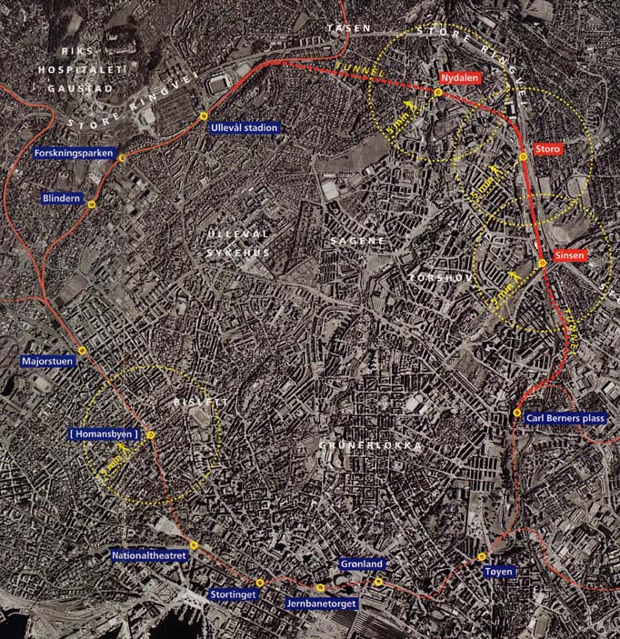
caption = Satellite map of the subway ring.
type =Rapid transit
system =Oslo T-bane
start = Majorstuen
end = Tøyen
stations = 9
open = 2003 to Storo
2006 to Carl Berners plass
close =
owner =Kollektivtransportproduksjon
operator =Oslo T-banedrift
character =
stock =
linelength =
tracklength =
notrack = Double
gauge = RailGauge|sg
el = 750 V DC (third rail )
speed = 70 km/h
elevation = |The Ring Line ( _no. T-baneringen) is the newest
rapid transit line of theOslo T-bane ofOslo ,Norway , completed onAugust 21 2006 . It forms a line north of downtown connecting the east and west sides of the network, the first such connection apart from the downtown central section. Storo and Nydalen stations opened onAugust 20 ,2003 , Sinsen when the circle was completed. The line connects with theGrorud Line in the east at Carl Berners plass and with theSognsvann Line in the west at Ullevål stadion.Operation of the circuit
The line is operated by lines 4 and 6, and partly by line 5.
Line 4 of the
Lambertseter Line runs through downtown then enters the loop. On the loop, at Ullevål stadion the line number changes to 6. The train continues around the loop, through downtown again, leaving on theKolsås Line in the west. Line 5 (theGrorud Line ) runs to Storo, but does not run round the complete loop.The line is not operated by trains on a continuous circuit, like the Circle Line on the
London Underground . The journey time of a complete loop is about 24 minutes, which coordinates poorly with the 15 minuteheadway on which the Oslo subway operates, and delays are difficult to remove on such a system.ee also
*List of stations on T-baneringen
References
* [http://www.aftenposten.no/english/local/article1429713.ece Royal launch for new tram line] Aftenposten, August 21, 2006
* [http://www.aftenposten.no/nyheter/iriks/article1428274.ece Now the ring is complete] Aftenposten, August 21, 2006 (in Norwegian)
* [http://www.sporveien.no/upload/Dokumentvedlegg/R2010Web.pdf Oslo Sporveier's strategic route plan 2006-2010] (pdf - in Norwegian)External links
* [http://www.sporveien.no/upload/Dokumentvedlegg/Nettkart/tbanenett_aug06.pdf Map of subway services from August 21, 2006] (pdf)
Wikimedia Foundation. 2010.
