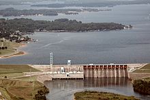
Cowans Ford Hydroelectric Station — Cowans Ford Dam Cowans Ford Hydroelectric Station is a hydroelectric power plant and dam located near Huntersville, North Carolina, approximately 20 miles north of Charlotte on Lake Norman. It is the largest conventional hydro station owned by… … Wikipedia
Catawba River — The Catawba River is a tributary of the Wateree River in the U.S. states of North Carolina and South Carolina. The river is approximately 220 miles (350 km) long. It rises in the Appalachian Mountains and drains into Piedmont, and is impounded… … Wikipedia
List of dams and reservoirs in the United States — This list is incomplete; you can help by expanding it. The following is a partial list of dams and reservoirs in the United States. There are an estimated 75,000 dams in the United States, impounding 600,000 mi (970,000 km) of river or about 17%… … Wikipedia
List of reservoirs and dams in the United States — There are an estimated 75,000 dams in the United States, blocking 600,000 miles (960,000 km) of river or about 17% of rivers in the nation . [cite web|url=http://www.pcffa.org/dams.htm |title=Dams and salmon |accessdate=2008 02 11] The following… … Wikipedia
Lake Norman — Infobox lake lake name = Lake Norman image lake = Lakenorman.jpg caption lake = typical coastline image bathymetry = caption bathymetry = location = North Carolina coords = coord|35|29|N|80|56|W|type:waterbody region:US|display=inline,title type … Wikipedia
Lake Norman — Uferlinie Lake Norman Geographische Lage North Carolina Zuflüsse Catawba River Abfl … Deutsch Wikipedia
Denver, North Carolina — Unincorporated Community … Wikipedia
Lake Norman State Park — Geobox Protected Area name = Lake Norman State Park native name = other name = other name1 = category local = North Carolina State Park category iucn = III image caption = etymology type = Named for etymology = Lake Norman country = United States … Wikipedia
North Carolina Highway 73 — NC 73 Map of southern North Carolina with NC 73 highlighted in red Route information … Wikipedia
Lake Norman State Park — (früher Duke Power State Park) ist ein 5,4 Quadratkilometer großer State Park nahe der Stadt Troutman, Iredell County im Bundesstaat North Carolina im Südosten der Vereinigten Staaten von Amerika. Der Park liegt an dem nördlichen Ufer des Sees… … Deutsch Wikipedia
 Cowans Ford Dam
