- Cowans Ford Hydroelectric Station
-
 Cowans Ford Dam
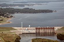
Cowans Ford Hydroelectric Station is a hydroelectric power plant and dam located near Huntersville, North Carolina, approximately 20 miles north of Charlotte on Lake Norman. It is the largest conventional hydro station owned by Duke Energy, generating up to 350 MW of power.
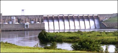
Three units began generating electricity in 1963, with a fourth unit beginning operation in 1967.
Cowans Ford Dam created Lake Norman, the largest man-made body of fresh water in North Carolina. The lake provides a dependable supply of water to Lincoln County and the communities of Davidson, Mooresville, Charlotte and Huntersville.
 Cowans Ford Dam
Although a small percentage of Duke Energy’s electricity is generated using hydroelectric stations, these plants supply “peaking power”—extra electricity needed to meet demand when it is needed most—typically hot summer days and cold winter mornings. Duke Energy’s hydro plants can be started to begin generating electricity in a matter of minutes.
References
Coordinates: 35°26′00″N 80°57′29″W / 35.4333333°N 80.95806°W
Categories:- Hydroelectric power plants in North Carolina
- Buildings and structures in Lincoln County, North Carolina
- Buildings and structures in Mecklenburg County, North Carolina

Wikimedia Foundation. 2010.