- North Absaroka Wilderness
-
North Absaroka Wilderness IUCN Category Ib (Wilderness Area)

Location Park County, Wyoming, USA Nearest city Cody, WY Coordinates 44°33′N 109°34′W / 44.55°N 109.567°WCoordinates: 44°33′N 109°34′W / 44.55°N 109.567°W Area 350,488 acres
(1,418 km2)Established 1964 Governing body U.S. Forest Service The North Absaroka Wilderness is located in Shoshone National Forest in the U.S. state of Wyoming. It lies adjacent to the eastern border of Yellowstone National Park.
U.S. Wilderness Areas do not allow motorized or mechanized vehicles, including bicycles. Although camping and fishing are allowed with proper permit, no roads or buildings are constructed and there is also no logging or mining, in compliance with the 1964 Wilderness Act. Wilderness areas within National Forests and Bureau of Land Management areas also allow hunting in season.
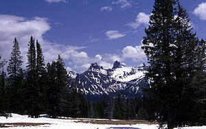 Pilot and Index peaks in the North Absaroka Wilderness
See also
External links
- "North Absaroka Wilderness". The National Wilderness Preservation System. Wilderness.net. http://www.wilderness.net/index.cfm?fuse=NWPS&sec=wildView&wname=North%20Absaroka. Retrieved 2006-08-16.
- "USGS Dead Indian Peak (WY) Topo Map Quad" (map). TopoQuest. http://www.topoquest.com/map.asp?z=12&n=4934484&e=613352&s=100&size=l&datum=nad83&layer=DRG25. Retrieved 2008-06-30.
- "Wilderness Legislation: The Wilderness Act of 1964". The National Wilderness Preservation System. Wilderness.net. http://www.wilderness.net/index.cfm?fuse=NWPS&sec=legisAct. Retrieved 2006-08-16.
Categories:- IUCN Category Ib
- Greater Yellowstone Ecosystem
- Protected areas of Park County, Wyoming
- Shoshone National Forest
- Wilderness Areas of Wyoming
- Wyoming geography stubs
- Western United States protected area stubs


Wikimedia Foundation. 2010.