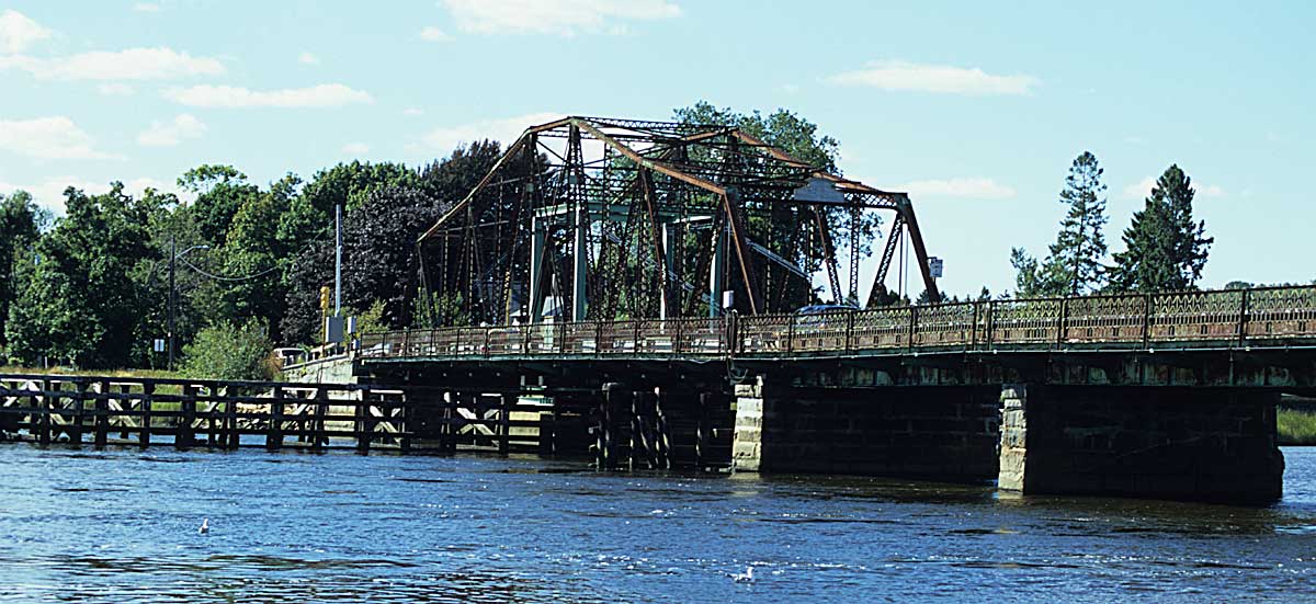
- Berkley-Dighton Bridge
Infobox Bridge
bridge_name=Berkley-Dighton Bridge
caption=
official_name=
carries=vehicular and pedestrian traffic
crosses=Taunton River
locale=Berkley and Dighton,Massachusetts
maint=
id=
design=swing bridge
mainspan=
length=
width=convert|21.3|ft
height=
load=3 tons
clearance=
below=convert|7|ft
traffic=
begin=
complete=
open=1801, 1896
closed=
toll=
map_cue=
map_
map_text=
map_width=
coordinates= coord|41|50|05.83|N|71|06|29.28|W|region:US_type:landmark|display=inline,title
lat=
long=The Berkley-Dighton Bridge is a paved one-lane swing-span bridge connecting the towns of Berkley and Dighton,
Massachusetts . Locally it is known as the Berkley Bridge. The current bridge, built in 1896, is the third at that location. The first bridge was built in 1801. There was no bridge on the site from 1853 to 1873.The bridge is the only crossing over the
Taunton River between the Brightman St. Bridge in Fall River (approximately 8.5 miles / 13.7 kilometers to the south) and the Weir St. Bridge in Taunton (approximately 4 miles / 6.4 kilometers to the north). The bridge is convert|21.3|ft|m wide, stands seven feet above mean high tide, and currently has a weight limit of three tons [ [http://townofberkley.com/townofberkley/LocalGroups/SOBS/Minutes/SOBSMinutesAprilSelect2005.htm Save Our Bridge April 2005 minutes] ] . It is the oldest swing-style bridge in theUnited States .History
The bridge was dedicated in 1896 with Luther Dean as the engineer, substructure built by Beattie and Wilcox of
Fall River, Massachusetts , and superstructure built by R.F. Hawkins ofSpringfield, Massachusetts .At one time, the bridge had two traffic lanes. However, the deterioration of the structure has reduced the bridge's weight-bearing capacity, and traffic is now restricted to one lane. Traffic over the bridge is controlled by a traffic light, which alternately allows eastbound and westbound traffic to use the single lane. The road approaching the bridge from Dighton (eastbound) is known as Center St.; approaching from Berkley (westbound) it is known as Elm St.
Opening the bridge
The towns of Dighton and Berkley pay a bridge tender to open the bridge as needed. Originally, the bridge was opened with a giant crank. The Dighton highway department installed a motor in the 1960s, though a tender is still required to grease the gears, unlock the bridge, remove some pins, and pull some switches to operate the mechanism.
Replacement
Proposals to replace the bridge have been discussed for many years. The
Massachusetts Highway Department (MHD) is now considering upgrading or replacing the Berkley-Dighton Bridge because its gears often jam in the open position, forcing travelers miles to the north or south. The MHD estimates (2001 data) that 6200 cars cross the bridge each day. Bridge upgrade plans have met with opposition for a variety of reasons, particularly concerns about the impact on local traffic. Commercial trucks are not allowed to use this bridge.See also
*
List of crossings of the Taunton River External links
* [http://townofberkley.com/townofberkley/LocalGroups/SOBS/SaveOurBridgeMain.htm Save Our Bridge site]
* [http://www.zwire.com/site/news.cfm?newsid=5099628&BRD=1711&PAG=461&dept_id=24232&rfi=6 Taunton Gazette article on bridge tender]References
Crossings navbox
structure = Crossings
place =Taunton River
bridge = Berkley-Dighton Bridge
bridge signs =
upstream = Weir St. Bridge
upstream signs =
downstream =Brightman Street Bridge
(Brightman Street Bridge Replacement under construction)
downstream signs =
Wikimedia Foundation. 2010.
