- Htigyaing Township
-
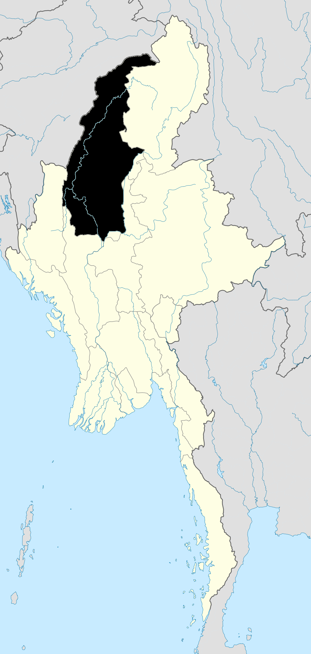
Htigyaing Township — Township — Location in Burma
 Htigyaing Township
Coordinates: 23°46′0″N 96°8′0″E / 23.766667°N 96.133333°ECoordinates: 23°46′0″N 96°8′0″E / 23.766667°N 96.133333°E Country  Burma
BurmaRegion Sagaing Region District Katha District Capital Htigyaing Time zone MST (UTC+6.30) Htigyaing Township or Tigyaing Township is a township of Katha District in eastern Sagaing Division, in northern Burma (Myanmar). It lies on the border with the Shan State of Burma. The administrative seat is at Htigyaing.
The Shweli River, a tributary of the Irrawaddy, forms part of the northern boundary with Katha Township and part of the eastern boundary with the Shan State.[1] The Indaung Reserved Forest and the Kyauktaung Reserved Forest are located in the eastern part of the township.[1]
Among the towns and villages in Tigyaing Township are: Aledaw, Datwin, Daungbin, Htidawgaing, Myadaung, Tawma and Wundingon.
Notes
- ^ a b Army Map Service, Corps of Engineers, United States Army (1954) "Mong Mit, Burma" topographic map NF 47-1, Series U542
External links
- Township 211 on "Myanmar States/Divisions & Townships Overview Map" Myanmar Information Management Unit (MIMU)
- "Tigyaing Google Satellite Map" Maplandia.com
Capital: HtigyaingAledaw • Apaukkyi • Baingbin Sakan • Bogon • Chundaung • Daungbin • Gahe • Gwebinchaung • Hpetkat • Indein • Ingyingôn • Kanbauk • Kanni (24°10'0"N 96°7'0"E) • Kanni (23°49'0"N 96°15'0"E) • Ketku • Kôkkôgon • Konywa • Kunbaung • Kunbudaw • Kunshin • Kwingyi • Kyaukmaw • Kyaukpaukchaung • Kyauksaung • Kyauksegôn • Kyauktayan • Kyaungyaung • Kyetsugyaung • Kyettagaung • Kyetthegyaung • Kyetthongin • Kyigandaung • Kyunchaung • Kyundaung • Kyungyi • Labaingdin (23°46'0"N 96°3'0"E) • Labaingdin (23°44'0"N 96°12'0"E) • Lèmi • Lethagôn • Lwingyi • Magyibin • Mahlainggyon • Maunggon • Mayathein • Meza • Mezali • Migyaungaing • Myadaung • Myebalin • Nampaung • Nānthe • Nat-in • Naunghpalan • Nwagaya • Nyaungbintha • Okshitkon • Okson • Padaukhla • Paukkon • Paukkon-ywa • Pauknet • Paukpingwe • Pegin • Pegon • Peinnegôn • Petkagôn • Pongongale • Pôngôngyi • Pyinde • Pyinzu • Sadwin • Satkya • Satsa • Seingyokon • Shwegyaung • Shweli • Sin-aing • Sinbyuzeik • Sinchidaing • Singaung • Singyun • Sittan • Songyun • Subokchaung • Tanbingôn • Tantabin • Taunglônnyo • Taungyagyi • Tawma • Tawya • Tedaw • Thapangaing • Thaunggyi • Thetkegyin • Thitnidaw • Thitpon • Tigyaing • Tonbon • Tongsi • Tonnge • U-baw • Wabogyaung • Wègyi (23°50'0"N 96°16'0"E) • Wegyi (23°44'0"N 96°3'0"E) • Wegyi (23°38'0"N 96°2'0"E) • Wundingon • Yingwin • Ywahaung • Zibyugyin • Zigon
Sagaing Region Capital: SagaingHkamti District Hkamti Township ( Singkaling Hkamti) · Homalin Township (Homalin)

Kale District Katha District Mawlaik District Monywa District Ayadaw Township (Ayadaw) · Budalin Township ( Budalin) · Chaung-U Township ( Chaung-U) · Kani Township (Kani) · Monywa Township (Monywa) · Pale Township (Pale) · Salingyi Township (Salingyi) · Tabayin Township (Tabayin) · Yinmabin Township (Yinmabin)Sagaing District Shwebo District Tamu District Tamu Township (Tamu)Naga Self-Administered Zone 

This Katha District location article is a stub. You can help Wikipedia by expanding it.

