- Togiak Airport
-
Togiak Airport 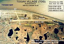
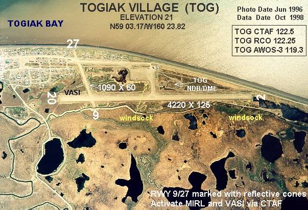
IATA: TOG – ICAO: PATG – FAA LID: TOG Summary Airport type Public Owner State of Alaska DOT&PF - Central Region Serves Togiak Village, Alaska Elevation AMSL 21 ft / 6 m Coordinates 59°03′13″N 160°23′49″W / 59.05361°N 160.39694°W Runways Direction Length Surface ft m 3/21 4,400 1,341 Gravel 10/28 981 299 Gravel Statistics (2006) Aircraft operations 10,200 Enplanements (2008) 1,781 Source: Federal Aviation Administration[1][2] Togiak Airport (IATA: TOG, ICAO: PATG, FAA LID: TOG) is a state-owned, public-use airport located in Togiak Village, in the Bethel Census Area of the U.S. state of Alaska.[1]
As per Federal Aviation Administration records, this airport had 1,781 commercial passenger boardings (enplanements) in calendar year 2008, a decrease of 6% from the 1,886 enplanements in 2007 and 43% from the 3,119 enplanements in 2006.[2] Togiak Airport is included in the FAA's National Plan of Integrated Airport Systems (2009–2013) as commercial service - non-primary, a category for airports with 2,500 to 10,000 enplanements per year.[3]
Contents
Airlines and destinations
Facilities and aircraft
Togiak Airport has two runways with gravel surfaces: 3/21 measures 4,400 by 75 feet (1,341 x 23 m) and 10/28 is 981 by 59 feet (299 x 18 m). The airport is unattended. For the 12-month period ending December 31, 2006, the airport had 10,200 aircraft operations, an average of 27 per day: 78% air taxi and 22% general aviation.[1]
Remarks:[1]
- Runways 10 & 28 non-standard markings; runways edges not marked, thresholds marked with damaged & faded panels.
- Activate MIRL runway 03/21 & VASI runway 21 - CTAF.
- Segmented circle damaged & overgrown with vegetation.
- Runway condition not monitored, recommend visual inspection prior to use.
- When available weather reports hourly only.
References
- ^ a b c d FAA Airport Master Record for TOG (Form 5010 PDF). Federal Aviation Administration. Effective 27 Aug 2009.
- ^ a b CY 2008 Passenger Boarding and All-Cargo Data (Preliminary). Federal Aviation Administration. Published 15 July 2009.
- ^ FAA National Plan of Integrated Airport Systems: 2009-2013. Federal Aviation Administration. Published 1 Oct 2008.
- ^ 2009 Timetables. Peninsula Airways. Retrieved 3 Sep 2007.
External links
- FAA Alaska airport diagram (GIF)
- FAA Terminal Procedures for TOG, effective 20 October 2011
- Resources for this airport:
- AirNav airport information for PATG
- ASN accident history for TOG
- FlightAware airport information and live flight tracker for PATG
- NOAA/NWS latest weather observations for PATG
- SkyVector aeronautical chart for TOG
Categories:- Airports in the Bethel Census Area, Alaska
Wikimedia Foundation. 2010.