- Saint Mary at Stoke
-
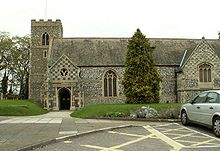 Saint Mary at Stoke from the front entrance
Coordinates: 52°03′01″N 1°09′11″E / 52.050202°N 1.152956°E
St Mary at Stoke, Ipswich 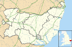
 St Mary at Stoke, Ipswich
St Mary at Stoke, Ipswich shown within SuffolkOS grid reference TM1643 Shire county Suffolk Region East Country England Sovereign state United Kingdom Post town IPSWICH Postcode district IP2 Police Suffolk Fire Suffolk Ambulance East of England EU Parliament East of England UK Parliament Ipswich List of places: UK • England • Suffolk Saint Mary at Stoke is a Grade I listed Anglican church Over Stoke[1] on the junction of Stoke Street and Belstead Road in Ipswich, Suffolk.
The church stands in a prominent position near the foot of a ridge, just south west of Stoke Bridge and the town centre. Its parish was a small farming community which saw a great increase in population with the coming of the railway to this part of Ipswich. It was once governed by Ely, a fact lightly made much of by a politician of Stoke [2]. In 1995 its parish was subsumed into the South West Ipswich Team Ministry in the Diocese of St Edmundsbury and Ipswich.
The building is made up of a small medieval church and a large Victorian extension designed by William Butterfield in 1872 [3]. A church has existed on this site since the 10th Century. It is probably one of the St Marys mentioned in the Domesday Book[4].
The original nave (now the north aisle) has a medieval single hammer beam roof, with moulded wall plates, angels with shields at the ends of the hammer beams, and figures underneath[5]. The angels are Victorian replacements for those destroyed by iconoclasts. The church was visited by William Dowsing. There is a medieval piscina.
References
- ^ Going Over Stoke by Linda Walker, BBC Local History
- ^ A History of Ipswich, Robert Malster, quoted in Ipswich was once part of Stoke
- ^ St Mary at Stoke, Ipswich from the Suffolk Churches website by Simon Knott
- ^ Medieval English urban history - Ipswich
- ^ Ipswich Churches Ancient & Modern, Roy Tricker, 1982, ISBN 0-9507064-9-3
Categories:- Church of England churches in Ipswich
- Grade I listed buildings in Suffolk


Wikimedia Foundation. 2010.