- Otterburn Training Area
-
Otterburn Training Area 
Type Training Area Coordinates 55°22′10″N 2°18′20″W / 55.36944°N 2.30556°W Current
ownerMinistry of Defence Controlled by Defence Estates[1] Main article: Cheviot HillsThe Otterburn Army Training Estate (ATE) was established in 1911[2] and covers about 230 square kilometres (90 miles)[3] of the Southern Cheviots. It is owned by the Ministry of Defence (MoD), and used for training some 30,000 soldiers a year. Otterburn is the UK's largest firing range, and is in frequent use — artillery can be clearly heard from Lindisfarne to the north-east and Fontburn Reservoir in the south. The ranges are used by AS-90 Artillery and M270 Multiple Launch Rocket System's and Otterburn is the only place in the UK where the MLRS can be fired, requiring a 11 mile long via 2 mile wide firing range[2][4].
The training area accounts for 23% of the Northumberland National Park[5].
Because of this, recreational use of the area is restricted, although it is possible for the public to use some parts of the estate subject to the relevant bylaws. The MoD publishes a booklet, Walks on Ministry of Defence Lands, which offers advice on this matter. [6].
-

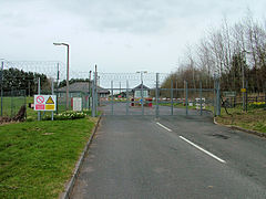
Otterburn Ranges. The road leading into the Ministry Of Defence Ranges, and the red flag showing that the army are practising live firing there
-
-
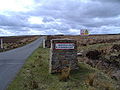
Entrance to the Otterburn Ranges near Holystone. Note the cattle grid.
- ^ Otterburn Ranges -About us (Website accessed: 22/08/10)
- ^ a b Otterburn Public Information Leaflet pdf (Website accessed: 26/08/10)
- ^ Welcome to Otterburn Ranges (Website accessed: 22/08/10)
- ^ Tanks for the wildlife - The Independent, 26 April 1997 (website accessed: 26/08/10)
- ^ Northumberland National Park - Otterburn Ranges (Website accessed: 22/08/10)
- ^ Walking guides on the Defence Estate, including Otterburn - Ministry of Defence
Categories:- Training establishments of the British Army
- Geography of Northumberland
- Sites of Special Scientific Interest in Northumberland
- Sites of Special Scientific Interest in England
- Otterburn, Northumberland
- Cheviot Hills
-


Wikimedia Foundation. 2010.