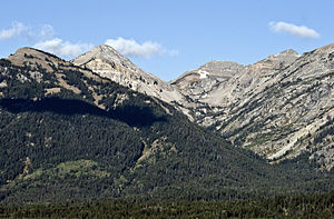
- Open Canyon
-
Open Canyon Open Canyon and Mount Hunt at leftCountry United States State Wyoming County Teton Source - coordinates 43°38′16″N 110°52′18″W / 43.63778°N 110.87167°W [1] Mouth Phelps Lake - elevation 6,634 ft (2,022 m) [1] - coordinates 43°37′42″N 110°48′18″W / 43.62833°N 110.805°W [1] Open Canyon is located in Grand Teton National Park, in the U. S. state of Wyoming.[2] The canyon was formed by glaciers which retreated at the end of the last glacial maximum approximately 15,000 years ago, leaving behind a U-shaped valley.[3] Open Canyon is situated between Mount Hunt and Prospectors Mountain and Coyote Lake lies at the head of the canyon.
See also
- Canyons of the Teton Range
- Geology of the Grand Teton area
References
- ^ a b c "Open Canyon". Geographic Names Information System, U.S. Geological Survey. http://geonames.usgs.gov/pls/gnispublic/f?p=gnispq:3:::NO::P3_FID:1601936. Retrieved 2011-05-21.
- ^ TopoQwest (United States Geological Survey Maps). Grand Teton, WY (Map). http://www.topoquest.com/map.php?lat=43.63728&lon=-110.84085&datum=nad83&zoom=8&map=auto&coord=d&mode=pan&size=m. Retrieved 2011-05-21.
- ^ "Park Geology". Geology Fieldnotes. National Park Service. http://www.nature.nps.gov/geology/parks/grte/index.cfm. Retrieved 2011-05-21.
Categories:- Canyons and gorges of Grand Teton National Park
- Wyoming geography stubs
Wikimedia Foundation. 2010.

