Frilandsmuseet

Frilandsmuseet
Frilandsmuseet
Established 1897
Location Lyngby, Denmark
Type Open air museum
Visitor figures 264,805 (2007)[1]
Website Frilandsmuseet

Frilandsmuseet (English: The Open Air Museum) is an open air museum in Lyngby at the northern outskirts of Copenhagen, Denmark. Opened in 1897 and covering 40 hectares, it is one of the largest and oldest open-air museums in the world.[2]

It is a department under the Danish National Museum and is part of the research done on agricultural history

Contents

Buildings

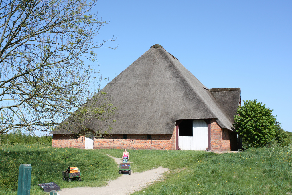
The museum features more than 100 buildings from rural environments and dating from 1650-1950. All buildings are original and has been moved piece by piece from their original location save a windmill that is still found in its original location.

Copenhagen open air museum 2.jpg

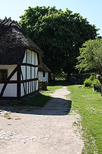
The museum contains rural buildings from all regions of Denmark, including many of the small and remote Danish islands like Bornholm, Læsø. Represented are also buildings from the Faroe Islands, as well as the former Danish possessions of Southern Schleswig in Germany and Scania and Halland in Sweden. The distribution demonstrates how life has been adapted to regional living conditions and availability of materials. Buildings include a farmhouse from the island of læsø thatched with kelp

Represented in the collection are also all social living conditions, from a manor house to a poorhouse, different types of buildings like farms, mills and workshops, and numerous professions..

The museum include six mills including a post mill from 1662. Some of the mills are regularly operated by a guild of volunteers.

Surroundings

The grounds of the museum also features 25 historic gardens and cultural landscapes and livestock of old Danish breeds. The gardens and animals are displayed in connection with the socially and geographically corresponding buildings.

Access

The museum has free admission and can be reached directly by bus number 184 from Nørreport Station in central Copenhagen or by S-train to Sorgenfri station.

See also

References

Coordinates: 55°47′10″N 12°29′32″E / 55.7861°N 12.4923°E / 55.7861; 12.4923


Wikimedia Foundation. 2010.

Игры ⚽ Поможем решить контрольную работу

Look at other dictionaries:

  • Список музеев под открытым небом — В данный список включаются музеи под открытым небом в узком значении, то есть музеи, основными экспонатами которых являются перенесённые архитектурные сооружения. Парки скульптур и парки миниатюр включатся в отдельные списки. Содержание 1… …   Википедия

  • Lyngby-Taarbæk — (official spelling. The spelling Lyngby Tårbæk is occasionally used) is a municipality (Danish, kommune ) in Region Hovedstaden near Copenhagen on the east coast of the island of Zealand ( Sjælland ) in eastern Denmark. The municipality covers an …   Wikipedia

  • National Museum of Denmark — Coordinates: 55°40′29″N 12°34′29″E / 55.674722°N 12.574722°E / 55.674722; 12.574722 …   Wikipedia

  • The Old Town, Aarhus — The old town The Old Town in Aarhus, Denmark (Danish: Den Gamle By), is an open air village museum consisting of 75 historical buildings collected from 20 townships in all parts of the country. In 1914 the museum opened for the first time as the… …   Wikipedia

  • The Funen Village — Scene from the Funen Village …   Wikipedia

  • Open Air Museum (Kongens Lyngby) — The Open Air Museum (Danish: Frilandsmuseet ) in Kongens Lyngby, Denmark is an open air museum displaying various historic dwellings, farms, buildings and landscapes from throughout Scandinavian history.ee also* The Funen Village * The Old Town,… …   Wikipedia

  • Freilichtmuseum des Dänischen Nationalmuseums — Ein Hof von der Insel Fanø (Fanøgård) Das Freilichtmuseum des Dänischen Nationalmuseums (Dän.: Frilandsmuseet) ist ein Freilichtmuseum in Dänemark. Das Freilichtmuseum liegt in Kongens Lyngby in der Gemeinde Lyngby Taarbæk nördlich von Kopenhagen …   Deutsch Wikipedia

  • Lyngby (Lyngby-Taarbæk Kommune) — Vorlage:Infobox Ort in Dänemark/Wartung/Fläche fehltVorlage:Infobox Ort in Dänemark/Wartung/Höhe fehlt  Kongens Lyngby …   Deutsch Wikipedia

  • Samsö — Samsø Samsø (dän ø = Insel) liegt im dänischen Kattegat, nördlich von Fünen. Als Gesamtgemeinde hat sie 4.124 Einwohner (2006) und ist 114 km² groß. Inhaltsverzeichnis 1 Geografie 2 Geschichte …   Deutsch Wikipedia

  • Lyngby-Taarbæk — Localización en Dinamarca. Lyngby Taarbæk Kommune (nombre oficial. También se puede escribir Lyngby Tårbæk Kommune) es un municipio danés, en la Región de Hovedstaden cerca de Copenhagen en la costa este de la isla de Selandia (Sjælland) al este… …   Wikipedia Español

Share the article and excerpts

Direct link
Do a right-click on the link above
and select “Copy Link”