- Ongjin (North Korea)
-
"Ongjin" redirects here. For the county in South Korea, see Ongjin County, Incheon.
Ongjin (North Korea) 
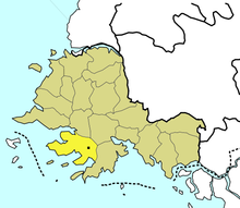
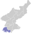
Location of Ongjin County within South Hwanghae Province.Korean name Chosŏn'gŭl 옹진군 Hancha 甕津郡 McCune–Reischauer Ongjin kun Revised Romanization Ongjin gun Ongjin is a county in southern South Hwanghae province, North Korea. It is located on the Ongjin Peninsula, which projects into the Yellow Sea.
Contents
History
The Ongjin Peninsula lies below the 38th parallel, and was therefore in the Southern zone, which became the Republic of Korea. However, the Ongjin Peninsula was isolated from other southern territories, and therefore difficult to defend. Some of the earliest fighting in the Korean War came here as Northern forces took the Ongjin Peninsula. The Armistice Line at the end of the Korean War left Ongjin County in North Korea.
Geography
Ongjin County is on the Ongjin Peninsula, with the Yellow Sea to the south and west. The Ongjin Peninsula is further divided into the Kangryŏng Peninsula, the Tongnam Peninsula, and the Ryongch'ŏn Peninsula. Geologically, Ongjin County is composed of coastal Lias. The Ongjin Plain, Kangryŏng Bay, Hwasan Bay, and Taedong Bay are all located here. The climate is very mild.
Ongjin County includes three large islands. Yonghodo (용호도) sits in the entrance to Kangryŏng Bay, Ch'angrindo (창린도) is outside the entrance to Ongjin Bay, and Kirindo (기린도) lies south of the western end of the Ongjin Peninsula.
Administrative Subdivisions
One ŭp, 23 ri, and 3 labor districts.
Economy
Rice is the major crop. Wheat, corn, beans, sweet potatoes, and cotton are also grown. The area was once heavily forested, but not much forest land remains. The nearby meeting of warm and cold currents make this a center of the fishing industry. Gold, silica sand, and marble are also mined.
See also
External links
- (Korean) In Korean language online encyclopedias:
- Military air bases in Ongjin County
South Hwanghae Capital 
Cities Counties Categories:- Counties of South Hwanghae
Wikimedia Foundation. 2010.
